
Lacustrine Source-Rock...................................................................................................................................Roche-mère lacustre
Rocha-mãe lacustre / Roca madre lacustre / Lacustrine-Muttergestein / 湖相烃源岩 / Озерная материнская порода , Озерная источник рок / Roccia fonte lacustre /
Lacustrine rock, rich in organic matter, which has been buried, sufficiently, so its organic matter can generate hydrocarbons in economically profitable quantities.
See: « Sealing-Rock »
&
« Source-Rock »
&
« Reservoir-Rock »
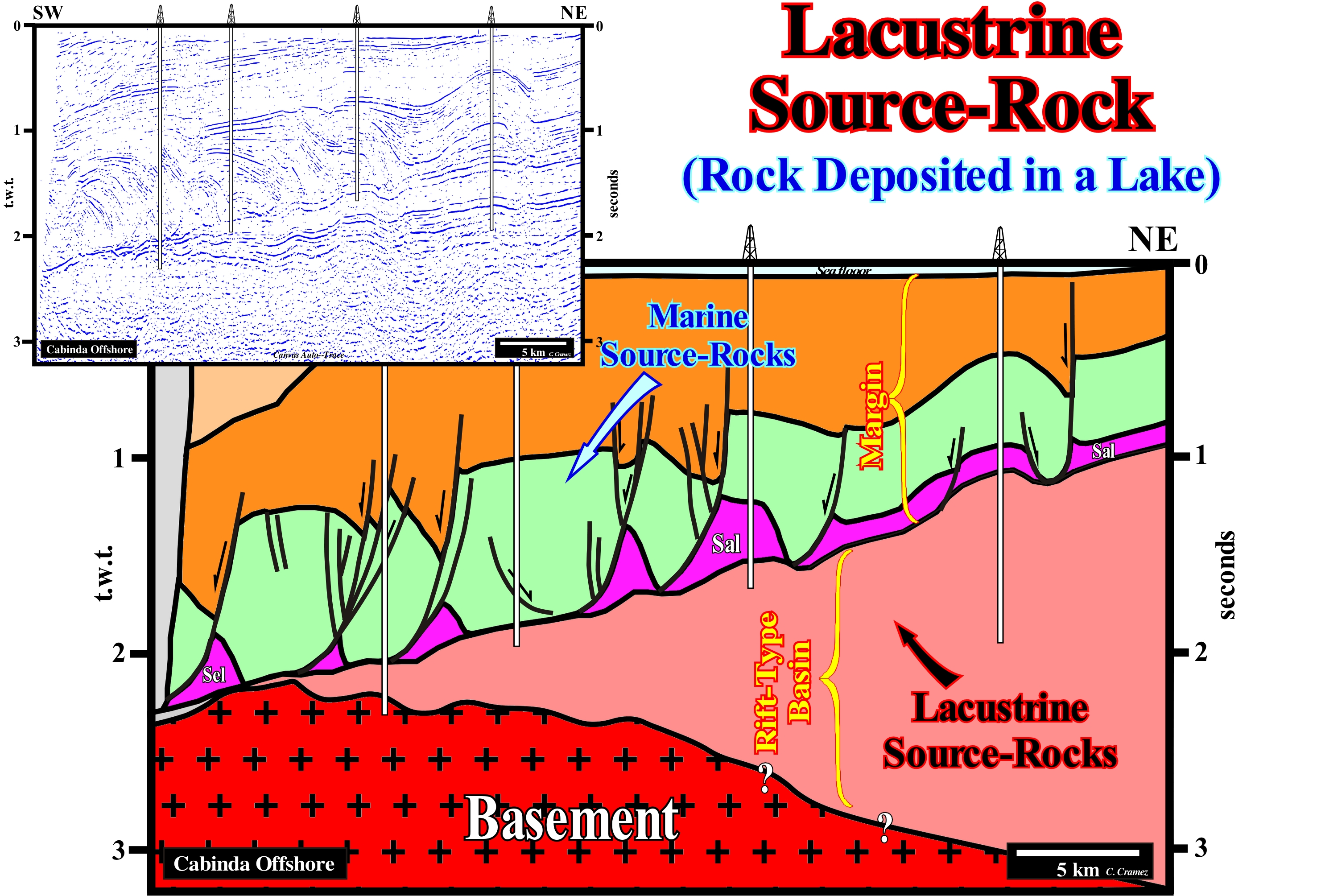
On this tentative geological interpretation of a Canvas auto-trace of a Cabinda (Angola) offshore seismic line, not far from the coastline, the lacustrine source-rock interval, within a rift-type basin is, easily, identifiable: its thickness is, more or less, constant and the internal configuration of the reflectors is, roughly, parallel. Such geometry means that during a certain period of lengthening of the lithosphere, before its break-up, i.e., during the formation of the rift-type basins, the rate of lengthening (extension) was, largely, superior to the terrigeneous influx. In other words, the terrigeneous influx was insufficient. Under these conditions, the formation of a water-depth is inevitable, which creates a, more or less, deep lake and, later, the deposit of a lacustrine interval rich in organic matter, if the conditions of formation and preservation of organic matter are present. When the rate of lengthening of the lithosphere, i.e., the differential subsidence, which creates the rift-type basins is, more or less, compensated for by the terrigeneous influx, all the created available space for the sediments is filled and no water-depth is developed. This implies, necessarily, that the deposited sedimentary intervals thick toward the normal fault bordering the rift-type basin and the internal configuration of the sedimentary intervals, which are composed mainly of sandy material, is divergence. Within a rift-type basin, which, generally, has the geometry of a half-graben, the entire interval with a, more or less, constant thickness and a parallel internal configuration is, likely, to correspond to lacustrine organic rich shaly rocks, i.e., they can be considered as potential source-rocks. If the burial of these intervals is large enough for their organic matter reach maturation, as it is the case illustrated on this tentative interpretation (taking into account the recent uplift of the margin), such lacustrine rocks are, generally, good source-rocks with high productivity.
Lafourche (Delta lobe).............................................................................................................................................................Lachourche (Lobe de delta)
Lafourche (lóbulo de delta) / Lafourche (lóbulo deltaico) / Lafourche (Delta-Lappen) / Lafourche(三角洲叶)/ Лафурш / Lafourche (lobo di delta) /
One of the six main lobes of the Mississippi Delta building: (a) Maringoiun; (b) Teche; (c) St. Bernard; (d) Lafourche; (e) Achafalaya and (vi) The Modern Lobe.
See : « Finger Delta »
Lag Deposit (Turbidites)...............................................................................................................................................Dépôt residual (Turbidites)
Depósito Residual / Depósito residual (turbiditas) / Residual Anzahlung (Turbiditen) / 剩余的存款(浊流)/ Задержанные наносы / Concentrazioni residue (di frammenti grossolani), Deposito residual (torbiditi) /
Accumulation of coarse material in the lower part of the continental slope, near the slope break, i.e., slightly upstream of the submarine basin floor fans. Residual deposits settle down when turbidite current begins to lose competence. In any current, turbiditic or no, the coarser material is transported at the base of the current with a velocity lower than the finer material. When a current begins to decelerate, the coarser material is left behind and is deposited, in general, filling small bathymetric anomalies.
See: « Submarine Basin Floor Fan »
&
« Turbidite »
&
« Incised Valley »
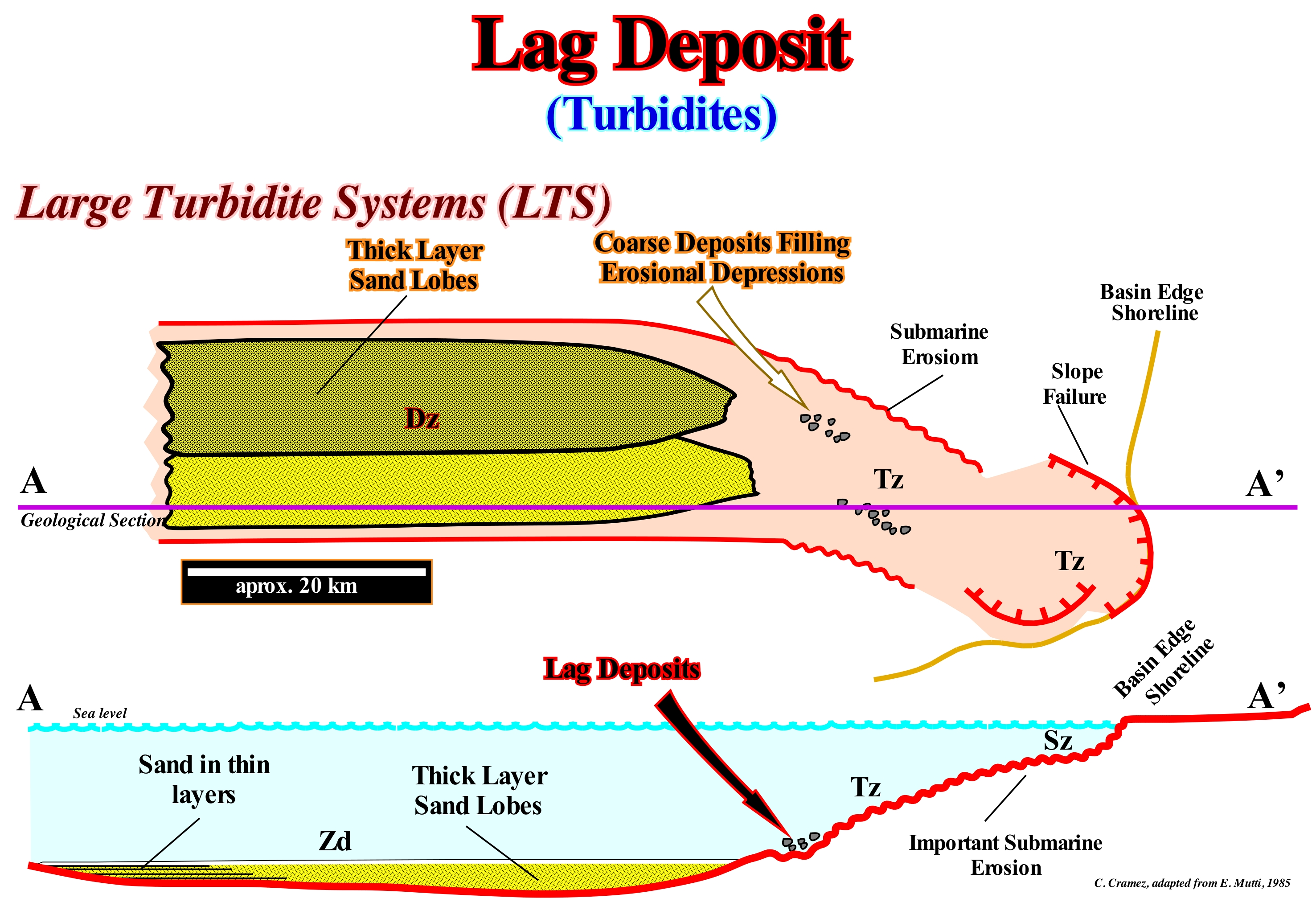
The upper sketch represents a geological map of a Large Turbidite System (LTS), that E. Mutti called Type I. The lower sketch represents the geological profile A'A of the system represented in the upper sketch (the profile is indicated by the horizontal line AA'). The main characteristics of a large turbidite system (LTS)*, in which lag deposits are frequent, upstream of the thick-layered sand lobes, are as follows: (i) It develops under highstand geological conditions (sea level above the basin edge), but, preferably, when the basin edge coincides with the depositional coastal break, i.e., when the basin has no shelf ; (ii) Turbidite currents are, normally, induced by instabilities of the basin edge that coincides with the coastal plain edge (continental edge) producing sliding failures, on the upper continental slope or by a significant submarine erosion ; (iii) Turbidite currents are very important and carry a large amount of sedimentary particles toward the deep parts of the basin ; (iv) Along the continental slope not only any significant deposition occur, but, on the contrary, locally, the turbidite currents erode the continental slope ; (v) Along the continental slope three sectors can be recognized (from the bottom to top): 1) Source Zone (SZ) with production of sedimentary particles ; 2) Transport Zone (Tz) and 3) Deposition Zone (Dz). Under these conditions, when turbidite currents reach the break of the lower continental slope, they have such a transport competence that the sedimentary particles are, sometime, transported during several tens of kilometers in the abyssal plain. Often, the thick-layered sand lobes can become disconnected from the immediately overlying sediments, i.e., they are, directly, fossilized by the deep sediments of the lowstand prograding wedge (LPW) of the sequence-cycle. The transport zone (Tz) allows the coarser sedimentary particles to settle in small negative anomalies of the substrate created, probably, by the erosion of the currents and form the so-called lag deposits, which are, more or less, distant from the main turbidite lobe. The transport zone (Tz) is downstream of the source zone (Sz) of the sedimentary particles, and upstream of the deposition zone (Dz). In this geological model proposed by E. Mutti, the geological conditions are of lowstand. The sea level is at the same level as the basin edge or slightly lower. Under these conditions, the rivers discharge the sediments on the continental slope creating currents of gravity. From the geological sketches illustrated in this figure we can say: (i) The unconformity (red wavy line) and its correlative deep-water paraconformity (red solid line) emphasize the lower boundary of the sequence-cycle where, in the distal area, submarine fans were deposited ; (ii) The unconformity (erosional surface and its correlative paraconformity were induced by a significant relative sea level fall that put the sea level lower than the basin edge ; (iii) Turbidity currents produce along the continental slope a submarine erosion that, locally, may be quite important ; (iv) The shoreline corresponds, more or less, to the continental edge (the basin has no shelf) ; it is underlined by failure scars that mark the beginning of the source zone (Sz) ; (v) Failures in the upper continental slope are also possible ; (vi) At the bottom of the continental slope, locally, erosional depressions form, which are, later, filled by coarse sediments, forming what geoscientists call lag deposits ; (vii) Downstream of the lower break of the continental slope, the turbidity currents decelerate depositing turbidite lobes which, generally, correspond to thick lobes of sand ; (viii) In the distal sectors of the turbidite lobes, the thickness of the sand layers decreases considerably ; (ix) Mutti's thick layered lobes correspond, roughly, to the submarine basin floor fans (SBFF) of P. Vail, which means that E. Mutti follows the Vail's model when there is a significant sea level fall, but he also admits the possibility of deposition of turbidite systems under highstand geological conditions, which is not the case of P. Vail.
(*) Deposit associated with deep submarine fans corresponding to Type I or Sub-stage I of E. Mutti. Often, these amalgamated turbidites are located in the central part of the turbidite lobes. They are composed by a stacking of deposits produced by consecutive turbidite currents (very separated in time). The thickness of these deposits can exceed several hundred meters. It can be said these deposits are characterized by a very weak presence of clay levels (which contrasts with the-laminated turbidites).
Laguna...............................................................................................................................................................................................................................Lac temporaire
Lago temporário / Lago temporario / Temporäre See / 临时湖 / Временное озеро / Lago temporaneo /
Low and ephemeral lake, generally, associated with desertic environments that is fed, almost exclusively, by currents formed only during storms with heavy rains.
See : « Lake »
&
« Meander BeltL »
&
« Proglacial Lake »
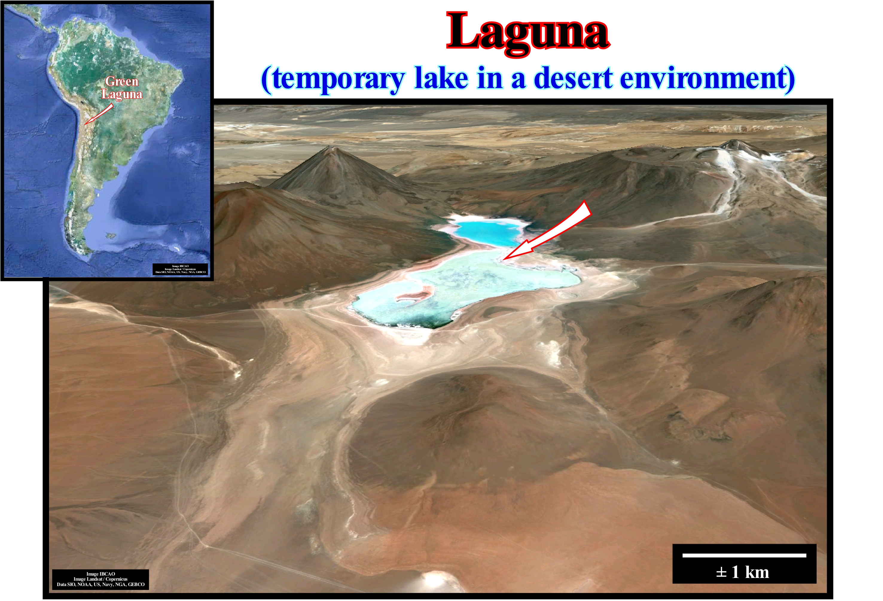
In general, water-bodies found on continents constitute a small part of the total amount of water of the biosphere. The oceans contain about 97% of the water of the biosphere. The sum of the water of glaciers, lakes, rivers, water vapour and groundwater represents just about 3%. Less than 1% of water exists in the form of free continental water (water from rivers and lakes), also called inland or interior water. Notwithstanding this small amount, the inland water is an essential element for the biosphere. It occurs in very varied forms and is used by a wide variety of biological communities very different from marine communities and terrestrial ecosystems. Of course, the interior water, which is formed from the water of the oceans, mainly by evaporation, can be: (i) Lotic, i.e., that flows and (ii) Lentic, i.e., that it does not flow and which is, more or less, stationary. As examples of the first type we can mention the water of the rivers, brooks, streams, etc., and of the second, the water of ponds, marshes, lakes, lagunas, etc. In the example illustrated in this photograph, the water of this temporary lake (laguna), which is fed, exclusively, by ephemeral currents formed during rainstorms, is lentic. Either way, both types of water (lotic and lentic) are related to three types of drainage systems: (a) Exorheic, when the drainage system is opened and the inland waters are transported to the ocean by the rivers ; (b) Endorheic when the drainage system is closed and the inland waters are concentrated in lentic water-bodies (permanent or temporary) from where they evaporate, and (c) Arheic, when the drainage system has no dominant direction, with water-falls used by inland waterways, that, in general, are provisional. In the areas of arheic drainage, apart from the allogene rivers (that are born outside the area) and the areas fed by underground water, the majority of the water-bodies are temporary.
Lagoon.............................................................................................................................................................................................................................................................Lagon
Laguna / Laguna / Lagune / 潟湖 / Атолловая лагуна / Laguna /
Portion of water isolated from the sea by a sandbank, which maintains a constant communication with it. Mass of water, generally, shallow separated from the sea by a beach barrier (tombolo, lido, etc.).
See : « Lake »
&
« Meander Belt »
&
« Proglacial Lake »

In its sedimentary evolution, lagoons, such as those illustrated in this figure (Lagoa dos Patos, Rio Grande do Sul, Brazil) are not very different from the "playas" of the endorheic basins (basins with a closed drainage system whereby the interior waters are concentrated in permanent or temporary water-bodies from which the water evaporates). As it is the case in the "playas", the lagoons are, rarely, fed on water, sweet or salty. They undergo intense evaporation as well as intense wind action. In general, they are natural salines, such as those of the arid part of the Gulf of Mexico (Laguna Grande) and those of certain points in the Mediterranean Sea. A typical example of a lagoon exists south of the city of Larnaca, on the Cyprus Island, where a salt lagoon (Larnaca Lagoon) is separated from the Mediterranean Sea by a barrier of sediments carried by the sea-waves. This lagoon is no more than 1 meter deep and its level is about 2 meters below the median sea level of the Mediterranean, which means that the sea-water, loaded with salt, infiltrates the lagoon through the barrier. As the rivers flowing into the Larnaca lagoon are insufficient to compensate the loss of water by evaporation there is precipitation of salt. Other examples of similar lagoons, studied and described by various geoscientists, exist in Egypt and bordering the Red Sea. In the saline of Mex (near Alexandria) a black mud is deposited on a coarse sandstone of sodium chloride, with corrugations, at 7-14 cm per year (Terrier, H. & Terrier, G., 1960). In the salty lagoons isolated behind the barrier, muds are deposited on which algae and vascular plants grow. In the tropical climates, it is in the lagoons that the mangroves are installed. Salty lagoons should not be confused with salt marshes (when the river valley is flooded by a relative sea level rise), as it is the case with the Tagus estuary (near Lisbon, Portugal), where the rise of the sea during the tide deposits on the banks a muddy material, which can evolve into salt marsh.
Lagoon (Carbonates)..................................................................................................................................................................................................................Laguna
Laguna (carbonatos) / Laguna / Lagune, Haff / 泻湖 / Лагуна / Laguna /
Water-body, relatively, shallow, separated, in general, from the sea by carbonated barrier islands.
See : « Lake »
&
« Atoll »
&
« Laguna »

In a horizontal plane, a coral atoll (coral reef) appears as a ring-shaped reef or a horse-shoe, which emerges from deep water and partially closes the lagoon. It is for this reason that atolls are, sometimes, called lagoon-islands. The structure of the atoll can be considered similar to that of coral constructions. It has many common points with the construction of the barrier-reefs. Like barrier-reef constructions, a structure of an atoll is characterized by: (i) An external undersea slope quite pronounced ; (ii) A crest formed of Lithothamnion (coral encrusting algae) ; (iii) A small internal platform, which limits the lagoon and (iv) The lagoon. The submarine outer slope can tilt more than 45° and even have cornices. The outer slope consists of living coral at the top and at the base by dead coral and numerous remains amalgamated into the reef by limestone algae. The algar crest formed Lithothamnion the base forms the outer margin of the reef that rises. This ridge exists only on the side where there are large waves, since this alga, unlike coral, lives only in areas of strong surf. The platform that emerges, sometimes, during low-tide, is a zone of a hundred meters, very irregular, formed of dead coral on which live coral colonies thrive. On this platform can be formed a series of micro-atolls in the centre of which the coral dies. It is this platform that surrounds the lagoon. The inner slope of the platform is softer than the outer slope. The lagoon is a succession of limestone bottoms and pinnacles of living coral that reach almost the sea level during low-tide. As, in general, the depth of the top of the pinnacles in the lagoon varies between 13 and 3 meters, it can be said the corals can live, perfectly, within the lagoon. For Darwin, the formation of a large majority of atolls can be summarized as follows: (i) Corals settle and grow around a volcanic island, forming a fringing reef ; (ii) The reef expands and the interior of the island collapses ; (iii) When the island, completely, collapses, there is a fringe of coral that continues to grow, at the same time that a, more or less, open lagoon forms in the centre.
Lahar....................................................................................................................................................................................................................................................................Lahar
Lahar / Lahar / Lahar / 山泥流 / Лахар / Lahar /
Mud flow, composed mainly of pyroclastic material, on the flanks of a volcano. Lahar is a Indonesian language word that designates a mixture of rock and water debris formed on the slopes of a volcano and flowing very quickly. Lahars can be formed in several ways: (i) Rapid melting of snow and ice due to pyroclastic flows ; (ii) Intense rainfall on volcanic deposits that are not very consistent; (iii) Rupture of a lake obstructed by volcanic deposits, etc.
See: « Debris Flow »
&
« Tephra »
&
« SDRs (seaward dipping reflectors) »
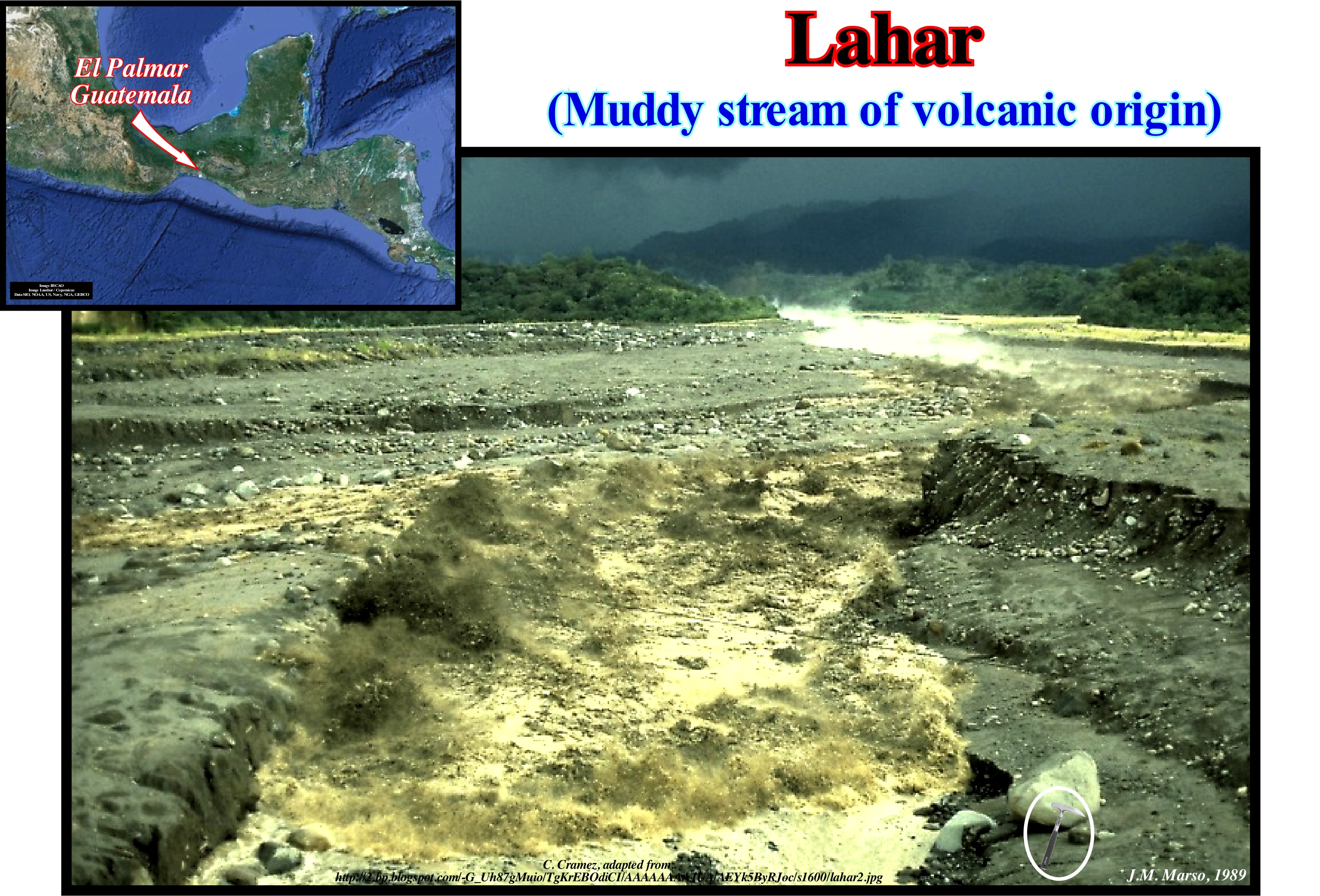
Basically, a lahar is a conglomerate associated with volcanic muds, which form after the eruption of a volcano. Mud formation is a frequent phenomenon on the volcanic slopes. The eruptions are, often, accompanied by heavy rains and the volcano itself emits water-vapour in large quantities, which condenses on the slopes. The retention lake, whether it be located behind the ashes or, even in the volcano crater, can, abruptly, empty itself, following a violent shaking and form enormous streams of mud, i.e., a lahar. Lahars move downhill, as any runoff, and submerge almost everything in their passage. The flow that occurred in the year 79 following the eruption of Mount Vesuvius, fossilized a large part of the Herculaneum Roman city, but leaving the ceilings of the houses intact. This did not happen in Pompeii city, where volcanic material falling from the sky left the walls of houses intact, but caused the house roofs to collapse. This figure shows the lahar, produced by rain-water, along the Nima II River, near El Palmar city (Guatemala), which formed on the slopes of the Santiaguito volcano, where conditions for the lahar's formation are ideal, since the eruptions destroy the vegetation at the same time, that deposit layers of inconsistent volcanic rocks. During the rainy season, when the rivers overflow, they erode those deposits and form lahars that are, extremely, dangerous. When there is no formation of lahars, erosion favours the deposition of sediments in the river bed, which of course favours flooding. The lahars contain a high concentration of debris from the flanks of the volcanoes and have a huge destructive power. If the sediment concentration is greater than 20% of the total flow volume, it is considered to be hyper-concentrated. If this proportion of debris is greater than 60%, the flow is called, by certain geoscientists, debris-flow, which can travel great distances, with a flow front moving at a speed that can reach 85 km/h. A typical example of debris-flow was caused by the Cotopaxi eruption in Ecuador, in 1877, which travelled more than 320 km at an average speed of 27 km/h. Lahars can also be considered mud-flows if the proportion of clay is high. The Pinatubo eruption on Luzon island (Philippines) that began in April 1991 and lasted more than a year, emitted a large amount of in-stabilized volcanic deposits. On June 14, the "Yunya" typhoon passed over the island. It was followed by other typhoons and in July, the lahars began to be, increasingly, important. This phenomenon was repeated at each rainy season or at every typhoon crossing for several decades. Sub-glacial volcanoes create particular lahars and glacial disasters, called "jokulhlaup" (literally "ice rush"). The example of the eruption of the Icelandic Katla volcano, under the Myrdalsjokull glacier, had this type of consequence. Similarly, in 1996, under the Vanatjökull (Icelandic glacier with 8,100 m², at 1,700 m altitude, that drains into the Atlantic Ocean), the heat of the volcano caused the melting of a large amount of ice and increased the volume of Lake Grimsvötn, located in the middle of the glacier, passing its surface from 12 km² to 40 km². Three cubic kilometers of pressurized water infiltrated under the glacier, and were, abruptly, released three weeks after the end of the eruption. On November 5, a "jokulhlaup" took place, carrying blocks of rock and ice. This enormous outflow reached the acme at 55,000 m²/s making disappear roads, bridges and houses. The sudden flood stopped the next day, abandoning an enormous amount of black mud, nauseating, but without making victims (http://www.earth-of-fire.com/article-les-sept-risques-volcaniques-5-les- lahars-63125559.html). The great lahar that destroyed Vila Franca do Campo (Portuguese village on the island of São Miguel, Autonomous Region of the Azores) on the night of 21 to 22 October 1522, causing thousands of deaths, covered with mud and stones about 3.5 km² of land. In the Azores there are many hundreds of geological formations identified as having been formed by lahars, some covering large areas, as is the case of the lahar which, from the Pico Rachado area, descended along the Ribeira de São Roque, in the Altares (Terceira Island), traveling more than 6 km to its end. A notable example of this effect of lahars is the presence of gigantic trachytic blocks, about 8-10 m high and weighing a few thousand tons, isolated on the plateau above the Caparica, Biscoitos, on Terceira Island. Those blocks were left there by a gigantic lahar that formed about 25,000 years ago during the last great eruption of the High Peak (Terceira). (https://blacksmoker.wordpress.com/ 2008/07/16/lahars-mudflows/).
Lake..................................................................................................................................................................................................................................................................................Lac
Lago / Lago / Lake / 湖 / Озеро / Lago /
The term "lake" comes from the Latin "lacus", which is given to a water-body or mass of more or less stagnant water, whose size is greater than that of a lagoon (between 20,000 and 80,000 m2) or any other mass of terrestrial water.
See : « River »
&
« Meander »
&
« Lacustrine Source-Rock »
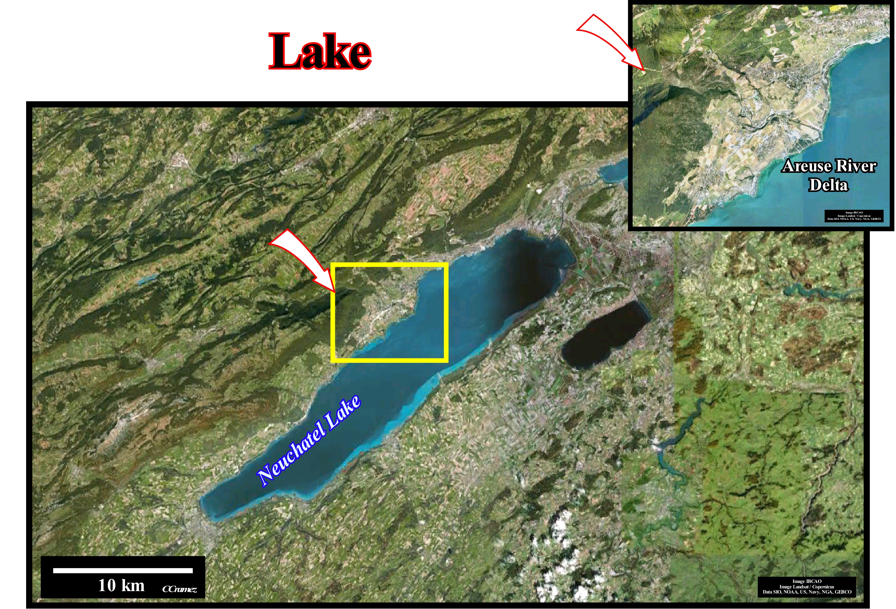
There are different types of lakes: (i) Peri-glacial lake, when a glacier, ice wall, or ice cap forms part of the lake's margins, that is to say, when ice obstructs natural drainage ; (ii) Sub-glacial lake, when the lake is permanently covered with ice ; (iii) Glacial lake, when the lake result from the melting of a glacier, such as those illustrated in this photograph of the Neuchâtel region (the eastern limit of the Swiss Jura) ; on the margins of this type of lake deltas developed under the wave influence can be formed (the Areuse delta is, fully, illustrated in the lower right corner of the figure) ; (iv) Artificial lake, when the lake is created by a flood behind a dam, human excavation, etc. ; (v) Terminal lake, when the lake associated to a river or underground diffusion has no outlet ; (vi) Meromictic* lake, when the different layers of water that constitute it do not mix (in general, the deeper layers do not contain any dissolved oxygen) ; (vii) Aeolian, i.e., a lake that forms in a depression created by the wind (water filling of a deflation basin) ; (viii) Ox-bow lake, when the lake is formed form in an old meander that was abandoned due to a meander net cutoff ; (ix) Reduced lake, when its dimensions decrease with time ; (x) Underground lake, when the lake is formed beneath the Earth's surface, in association with grottos, caves, aquifers, springs, etc. ; (xi) Crater lake, when it forms in the volcanic caldera, as long as a volcano is no longer active ; (xii) Lava lake, formed by molten lava contained in a volcanic crater or any other depression ; (xiii) Pre-existent lake, which no longer exist (many of these lakes disappeared by evaporation or human intervention) ; (xiv) Station lake, i.e., that exists as a water-body just during part of the year ; (xv) Rift-lake, when it is formed in an area of strong subsidence associated with the break-up of the lithosphere ; (xvi) Fjord lake, when it is formed in a glacial valley that has been eroded lower than sea level level, etc. The Baikal lake, located in southern Siberia is the world's deepest and oldest lake in continuous existence. It corresponds to a huge graben that started to fill with water about 25 Ma. Presently, its is 365 km long and 16-80 km wide. Its surface is about 312079, 857 km2. Its depth reaches 1,600 meters. The Bailkal lake holds, more or less, 20% of the all the world's liquid fresh water, that is to say, it holds as much water as all the Great Lakes hold together
(*) In a holomictic lake there is, at least once each year, a physical mixing of the surface and the deep waters.
Lamina (Sedimentary)..........................................................................................................................................................................................Lamina (Laminas)
Lâmina / Lámina (láminas) / Lamina (Sediment) / 椎板(沙) / Тонкий породный прослоек / Lamina (sedimento) /
Basic sedimentary unit, which produces the stratification (as a layer). The transition between a lamina and a layer is, arbitrarily, taken at 10 millimeters thick. When a lamina or a layer shows a decrease in grain size towards the top, it is, theoretically, associated with a decrease in the flow velocity of the stream.
See: « Sedimentation »
&
« Bed »
&
« Flux (flow) »
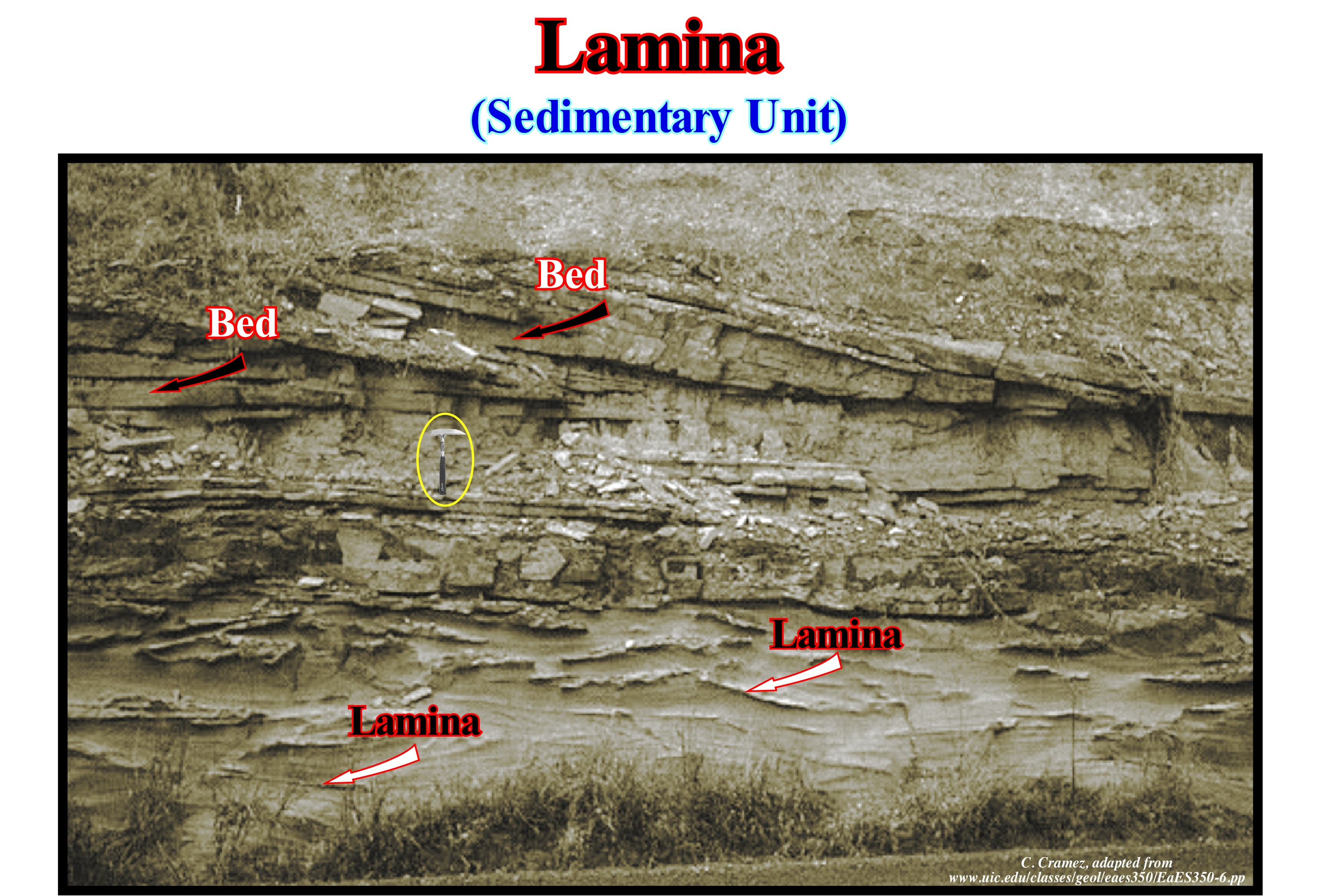
The great majority of sedimentary rocks can be divided into: (i) Beds; (ii) Strata and (iii) Laminae. A bed is a stratum considered fundamental to a given scale of observation. A stratum is a physical unit or, visually, distinct, defined by the distribution of its depositional characteristics or by the presence of surfaces, which delimit a primary or erosive origin. A lamina (plural: laminae) is the smallest layer visible to the naked eye. The strata, which vary according to more or less organized patterns, can be: (a) Rhythmic ; (b) Cyclic and (c) Graduate. It is rhythmic when two lithologies alternate (ABAB ...). Cyclic, when more than two lithologies alternate (ABCBA ...) and Graduate, when the strata present a gradual change of granulometry. Bedding (stratification) is a physical separation surface indicating a segregative deposition in space and/or time, and which can be originated in two ways: (A) A pause in the deposition, linked to a sudden change of depositional conditions (environment energy or sedimentary particle supply) ; (B) A spatial selection of the grains under constant supply and energy. All surfaces limiting the strata represent a small gap (time-interval of non-deposition). When the hiatus is large the surface is an unconformity, which can be tectonically enhanced (angular unconformity) and which is associated with a relative sea level fall. All stratigraphic unconformities represent a minimal hiatus. The implications of the surfaces, which limit the strata, can be summarized as follows: (1) They represent a hiatus ; (2) The gap (hiatus) can vary from place to place ; (3) A small hiatus is found along the entire surface ; (4) They are dependent on the time scale and the rocks considered. Laminae and beds are visible in this photograph. However, the transition between them is very arbitrary. It depends not only on the thickness, but also on colour, composition and grain size changes.
Laminar Flow............................................................................................................................................................................Écoulement laminaire
Fluxo Laminar / Flujo laminar / Laminare Strömung / 层流 / Ламинарный поток / Flusso laminare, Régime laminare /
Flow of a fluid in which the flow lines are distinct and parallel, i.e., do not mix. Synonym for Laminar Flux.
See: « Flux (flow) »
&
« Lahar »
&
« Turbulent Flow »

A laminar flow is, relatively, homogeneous and un-interrupted, such as, for instance, the air flow over the wings of an in-flight aircraft. The laminar flow, often, develops in front of a moving body. It is a key factor when an object flies. If the airflow is interrupted in a section of a wing of an airplane, turbulence is formed, which produces a loss of the climbing force and an increase of the draw. As shown in this figure, the curved structure of the wings of an airplane is designed so that there is a minimum of draw and a laminar flow without interruption. To better understand the laminar flow, open a faucet slowly. The water flows in an orderly manner. If there is no wind or any other disturbance, nothing will change, the water will flow in a laminar manner. The flow is deterministic, i.e., the future behaviour is, completely, determined by the specification of the present or past flow. Now, open the faucet completely, the water movement is faster and the water quantity is larger. The flow pattern changes at every instant. Although on average the movement is in the same direction, there are irregularities throughout the flow. The flow is turbulent. Although the turbulent flow proceeds in the same direction as the laminar flow. It exhibits complex and chaotic velocity fluctuations, which means that the patterns of a turbulent flow never repeat. A slow flow tends to be laminar, whereas a fast flow tends to be turbulent. A slow flow from a large hole can be turbulent. Expert engineers in this subject do not like to say "fast", "slow", "small" or "large", since there is no reference: "small" in relation to what? Since turbulent flow is a different flow rate than laminar, it is preferable to quantify the occurrence conditions whenever possible, taking into account dynamic and kinematic viscosity (viscosity divided by velocity) and flow velocity. In this figure two different types of flow of a fluid are illustrated: (i) Laminar Flow and (ii) Turbulent Flow, which oil companies have studied very carefully, since they can occur when oil is transported along the pipelines. These flows have quite different consequences. The upper right-hand diagram (laminar flow) shows, in longitudinal section, the flow of a liquid through a cylindrical tube (like that of an oil pipeline). For such a flow to occur, simply place a pump on the right end of the tube, which sucks liquid through the tube. If the pump sucks the fluid slowly, the flow is controlled and the flow direction profile is stable, i.e., that laterally, the fluid does not mix (laminar flow). If velocity increases, the flow becomes turbulent, that is to say, the fluid movement is random and unpredictable. In order to predict the change from a laminar to a turbulent flow, several scientists have advanced a prediction model. There appears to be a fluid velocity (vx), which can be calculated in many situations by the Navier-Stokes equations, which describe the movement of the non-compressible viscous fluids. In fluid dynamics, a laminar flow is a flow regime characterized by: (i) A large momentum (product of mass and velocity) of diffusion* ; (ii) A low convection moment (movement of molecules inside a fluid) ; (iii) A pressure (force per unit area applied perpendicular to a surface) and (iv) A velocity (rate of change of position) independent of time. An example of laminar and turbulent flow is the smoke, which rises from a cigarette resting on an ashtray. At first, the flow is laminar, but as the smoke rises, it becomes turbulent. In the same way, if you open a tap, progressively, you will see that the flow goes from rolling to turbulent.
(*) Transport of the molecules from one region with high concentration to another with low concentration via a movement randomization of the molecule.
Lapiaz (Lapies, coastal lapiaz, littoral clints).................................................................................................Lapiaz, Lapiez (Lapies littoral)
Litoral Lapiaz / Lapiaz / Rüstenkarren, Litoral Schratten / 升级车 / Прибрежный карр / Karren /
Surface geological formation in limestone and dolomitic rocks, created by the flow of rain that dissolves the rock or by freeze-thaw cycles inside the rocks (cryoclastics).
See : « Littoral »
&
« Karst »
&
« Fair Weather Wave Base »

The alteration of limestone rocks by water consists essentially of dissolution. In limestone rocks, it can be said the dissolution is in opposition to the glyptogenesis (erosion), particularly abrasive, of the crystalline and detrital rocks, but also to the lateritic process, which is chemical in nature. In reality, on the surface of a limestone layer, the simpler dissolution processes, plus small funnel-shaped holes that are, often, very visible, but which quickly merge to form small ditches (drains) that with time become deeper and deeper over time to finally form the lapiaz, as illustrated in this figure (Alto des Brenas, Cantabria, Spain). The grooves of the lapiaz can be of three types: (i) Drains ; (ii) Slits and (iii) Overdraft. The drains line up along the line of greatest slope and which, in general, are rectilinear or slightly sinuous. The slits correspond to deepening of cracks and which cut the rock into blocks. Overdraft are found, in general, on covered lapiaz, but without ground cover. These lapiaz, which may be called continental lapiaz, should not be confused with the coastal lapiaz which develop in the foreshore (upper meso-littoral stage) and in the supra-littoral zone of calcareous coast lines, as example, those shown in the diagram to the left of this figure. The littoral lapiaz can take the form of pinnacles, with sharp edges, leaving between them small pots of dissolution sometimes in the form of funnel. In the upper part of the foreshore, due to the infiltration of the spray droplets and the foam of the waves, the lapiaz become sharp and with many furrows of erosion. In the inter-tropical regions these forms are very developed and, sometimes, have an aspect of fields of ruins. The lapiaz generated in the sub-soil tend to take softer and larger forms than those formed on the surface.
Lapout (Pinchout).............................................................................................................................................................................................................Bisellement
Acunhamento (biselamento) / Biselamiento (acuñamiento) / Abschrägung / 斜角 / Седиментационное выклинивание пластов / Smussatura, Bisello /
Lateral termination of a stratum or a seismic reflector within the limits of its deposition, in general, against an unconformity (erosional surface). There are two types of termination: (i) Basal Termination occurring at the lower limit of either the sequence-cycle or a sequence-paracycle and (ii) Top Termination occurring at the upper limit. A basal termination may be aggradational (onlap) or progradational (downlap). A top termination can be by truncation (erosional) or by non-deposition. Synonym with Onlapping.
See: « Sequence-Cycle Boundary »
&
« Onlap »
&
« Aggradation »
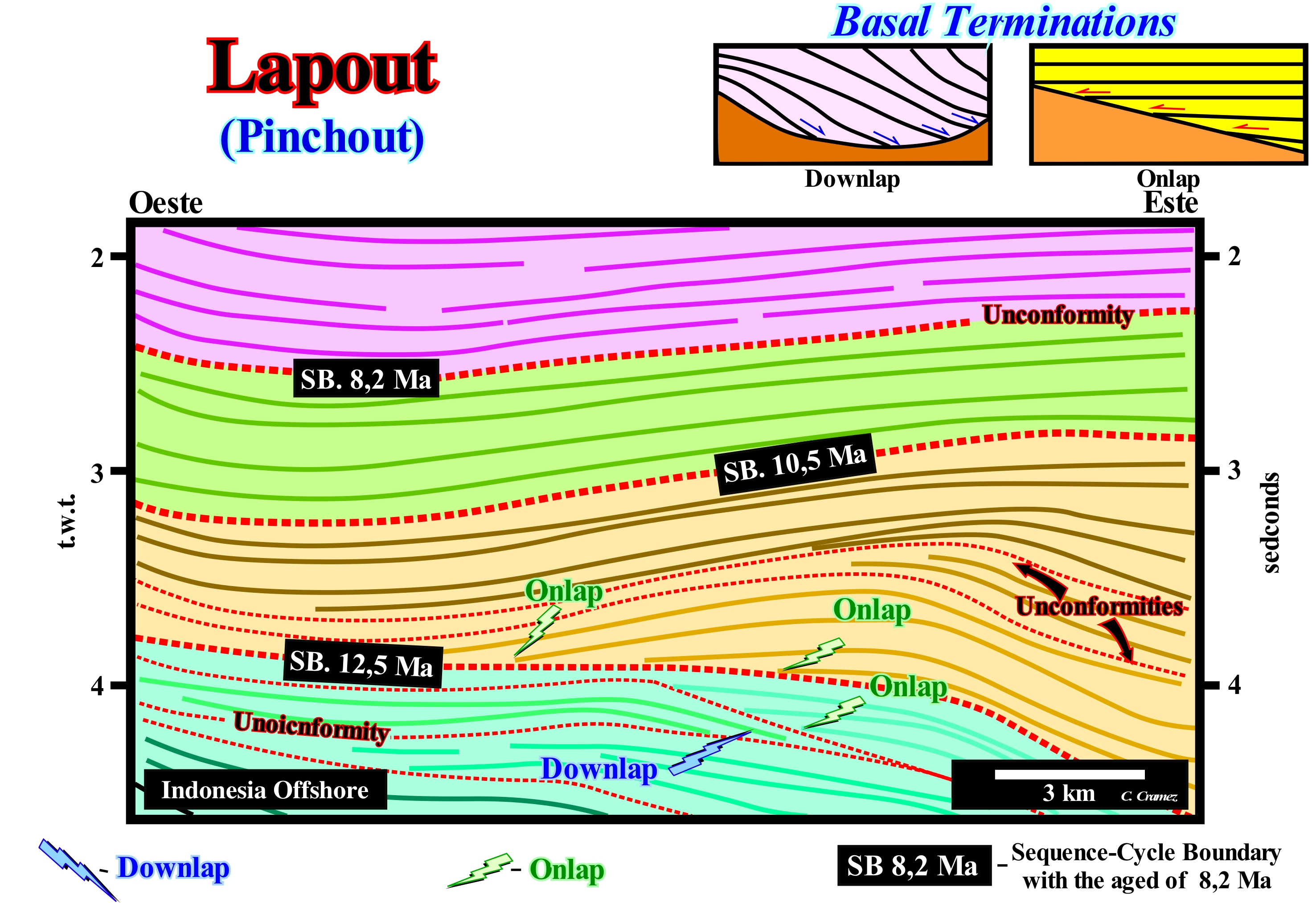
On this tentative geological interpretation of a Canvas auto-trace of a Mahakam offshore seismic line (East coast of Borneo, Indonesia), which corresponds to a back-arc basin of the classification of A. Bally and Snelson (1980), can be put in evidence: (i) A lengthening or rifting phase at the base, and (ii) A sag or thermal phase at the top. The rifting phase is characterized by a differential subsidence that induces the formation of half-graben structures, while the sag phase is characterized by thermal subsidence. The seismic line, from which this Canvas auto-trace was made, passes through a gas field which has recoverable reserves between 15-20 Tcf* (not to be confused with reserves, which are hydrocarbons that can be produced in a cost-effective manner under current technological and economic conditions, with resources that represent hydrocarbons in situ, which could one day be produced if economic and technological conditions improve). The lapout of the seismic reflectors, which in this particular case appear lapouts by onlapping, are readily visible. This is, above all, true, under the upper limit of the sequence-cycle, limited by the unconformities SB. 10.5 Ma and SB. 12.5 Ma**. The age difference between these unconformities is less than 3-5 My, which suggests the stratigraphic interval they limit was induced by a 3rd order eustatic cycle, that is to say, by a relative sea level cycle with a time-duration between 0.5 My and 3-5 My. The seismic reflectors, which on this tentative interpretation are underlined by continuous traces with different colours, correspond to time lines, i.e, chronostratigraphic lines that are, more or less, parallel to the bedding planes of the sedimentary packages that define the seismic interfaces. The onlaps (lateral termination of reflectors) define seismic surfaces (dashed lines) that characterize, in this particular case, significant relative sea level falls (unconformities). These relative sea level falls induced seaward displacements (toward the basin) and downward (negative aggradation) of the coastal onlaps (near the coastline), which emphasizes lowstand geological conditions relative to the basin edge). The strong sedimentation rate, which occurred in this area (during the Miocene), allows us to recognize, within the sequence-cycle SB. 10.5 Ma / SB. 12.5 Ma, two other unconformities (sea level falls), which are underlined in this interpretation by the finer dashed lines. It may be said that the sequence-cycle SB. 10.5 Ma/12.5 Ma is formed by the stacking of stratigraphic cycles of higher hierarchical order (high frequency cycles), which are, often, not represented in the Vail curve (coastal onlap curve). In Geology and in particular in Sequential Stratigraphy, by convention, SB. 10.5 Ma, for instance, is the unconformity with age 10.5 million years ago, which is the boundary between two stratigraphic cycles, probably two sequence-cycles. Put another way, 10.5 Ma is a geological age, while 10.5 Ma is a time-interval. The age of an unconformity is given by the age of the relative sea level fall that induced it, as well as its deep-water correlative paraconformity. In general, the age of an unconformity is given by the age of the deep-water turbidite deposits (submarine basin floor fans) of the overlying sequence-cycle that underlines the minimum hiatus between the sequence-cycles separated by the unconformity. In this sense, it can be said an unconformity corresponds, roughly, to a chronostratigraphic along which conventional physiographic provinces can be individualized (coastal plain, shelf, continental slope and abyssal plain). On a regional seismic line and in the absence of tectonically enhanced geometric relations between the reflectors, an unconformity is, easily, recognized in the upper part of the continental slope when submarine canyons fills are present. Upstream of the continental edge, with which the basin edge may coincide (where the basin does not have a shelf), the identification of an unconformity depends mainly on the presence or not of incised valley fills. In all other cases, the unconformities are cryptic. Taking into account the seismic resolution, which is, generally, greater than 20-40 meters, it is obvious that a chronostratigraphic reflector (time line) does not correspond to a bedding plane between two sedimentary layers, but to an interface between two sedimentary packages (which can be mapped) with lithological, more or less. similar. petrophysical and environmental characteristics.
(*) Tcf is a volume measure used by the oil industry. It corresponds to a billion cubic feet (1 x 10¹² cubic feet). It is a measure of natural gas volume that is equivalent to approximately a Quad. A Quad is an abbreviation for billions (1 x 10¹⁵) of Btu. Btu (British Thermal Unit) is a unit of energy measurement, representing the amount of heat needed to raise the temperature of a pound of water to a Fahrenheit degree. In the oil and gas industry, units of measure represented by letters where M = thousand; MM = 1 million (1 x 10⁶) ; B = one billion (1 x 10¹²) and T = one trillion (1 x 10¹⁸). Either of these may appear before some terms, such as MMBOE (million barrels of oil equivalent) or (Tcf billion cubic feet).
(**) "Ma", i.e., millions of years ago indicates a geological age, while "My" is used for a certain time interval regardless of geological age.
(***) The hierarchical order is determined by the duration of the associated eustatic cycle. The shorter the duration, the higher the eustatic cycle hierarchy and the associated stratigraphic cycle. A first order eustatic cycle, whose duration is greater than 50 My, have a low hierarchy, as well as the associated stratigraphic cycle induced by it.
Lapout (Lateral termination).......................................................................................................................................................................Biseautage (Bisellement)
Biselamento (acunhamento) / Biselamiento (acuñamiento) / Verkeilen, Bevel (bisellement) / 楔入 / Седиментационное выклинивание пластов / Incuneamento /
Lateral termination of a seismic stratum or reflector at its deposition limits. The lapout associated with the upper limit of a stratigraphic cycle can be underlined by a toplap (progradation) or by an onlap (of the overlapping sequence-cycle), whereas that associated with the lower limit can be underlined by a downlap or by distal onlap.
See: « Lapout »
&
« Onlap »
&
« Continental Encroachment »
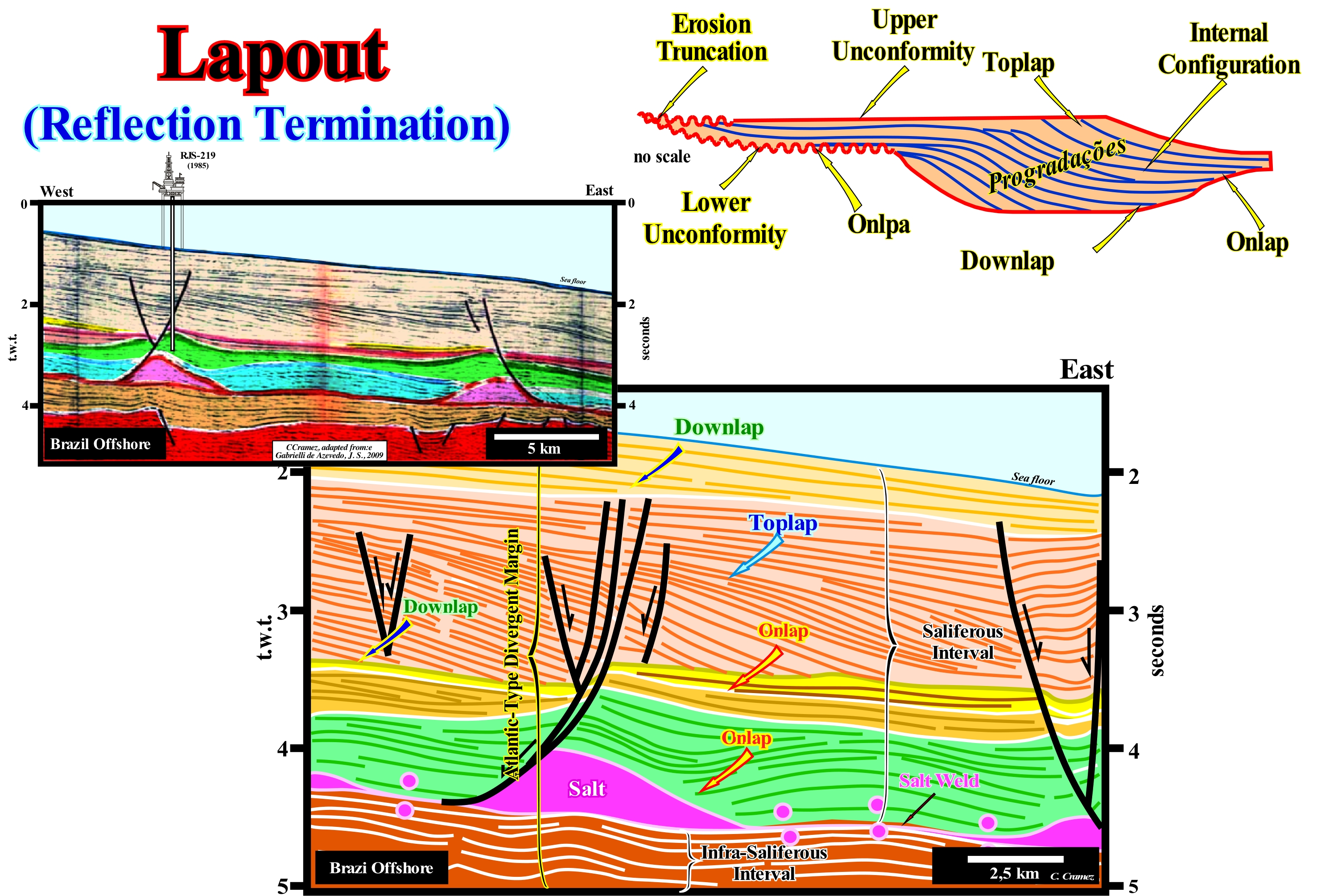
East Brazil offshore corresponds to the stacking of three types of sedimentary basins of Bally and Snelson (1980) basins classification. From bottom to top, they are: (i) Basement or Paleozoic flattened mountain belt ; (ii) Late Jurassic/Early Cretaceous rift-type basins ; (iii) Mesozoic/Cenozoic Atantic-type Divergent Margin. The rift-type basins were formed during the lengthening of the Gondwana small supercontinent, before the break-up of the lithosphere. On this tentative geological interpretation of a Canvas auto-trace of a detail of a seismic line Campos offshore (Brazil), several types of lapout are visible. Within a sequence-cycle, deposited during a 3rd order eustatic cycle, whose time-duration varies between 0.5 My and 3-5 My, relatively to the lower sequence boundary, the basal geometrical relationships can be onlap or downlap. Relatively to the upper sequence-boundary, the reflection or strata reflections, i.e., the toplaps can be: (a) By truncation (when there is erosion) or (b) By non-deposition when it is difficult or impossible to decide whether there was erosion or not. On this tentative geological interpretation, all types of reflector terminations are clearly visible, as well as, the associated seismic surfaces*: (i) Onlaps ; (ii) Downlaps; (iii) Toplaps by truncation ; (iv) Toplaps by non-deposition ; (v) Onlapping Surface ; (vi) Downlapping Surface ; (vii) Toplapping Surface, etc. This tentative geological interpretation is very different from the geological interpretation made in the 1980s (Petrobras interpretation), is, often, used to illustrate the importance of serendipity in petroleum exploration. In fact, the target of the first exploration well (located on the seismic line of this tentative interpretation) was the turtle-back antiform structure (within the green interval), created by the flowage of the salt interval, which is still visible in the lower right part above the salt-weld (salty suture). However, as everyone knows, when an exploration well is drilled in a sedimentary basin little affected by tectonics, to reach the Cretaceous sediments (the age of the sediments forming the turtle-back antiform, and not turtle-back anticline), it is necessary to cross the Cenozoic overlying sediments, if these have deposited and were not eroded, which is the case here illustrated. In mid-January 1985, the Petrobras exploration well (RJS219A) reached the interval underlying the continental slope progradations, i.e., it reached the yellow colored interval (which had not even been interpreted), which is characterized parallel and sub-horizontal internal configuration (presently interpreted as a submarine basin floor fans). "Bingo", the well found, hundreds of meters before the target, a thick sand interval with oil found (Marlin Petrobras discovered, whose original recoverable reserves were close to the 4 Gb), which was not even taken into account in the well prognosis. It was for this reason that my mourned friend and colleague Celso Ponte told me: " Carlos do not forget, God is Brazilian". Examples of this type were also very frequent in the oil exploration in North Sea, as well as in the Angola deep offshore. The Girassol discovery (Elf), as well as, the Kuito discovery (Chevron, Total) are, like Marlin discovery, magnificent examples of serendipity** (certain geoscientists will certainly say the opposite, forgetting that, at that time, I was working in one of the exploration team). It is interesting to note that in this tentative interpretation, just the divergent margin is represented, which, in stratigraphic terms, can be divided into two intervals separated by the evaporitic interval or by the associated tectonic disharmony: (i) Suprasalt interval and (ii) Infrasalt interval. However, the boundary between these two intervals does not correspond to any unconformity, i.e., to any erosional surface.
(*) Surfaces determined by seismic reflector terminations (lapouts) , which, in most cases, are not emphasized by reflectors. The downlapping and the onlapping surfaces are examples of seismic surfaces.
(**) The word serendipity was created by the British writer Horace Walpole in 1754, in the Persian children's tale "The Three Princes of Serendip". This story of Walpole tells the adventures of three princes of Ceylon, present-day Sri Lanka, who lived making unexpected discoveries, whose results they were not really looking for. Thanks to their capacity for observation and wit, they "accidentally" discovered the solution to unthinkable dilemmas. This characteristic made them special and important, not only because they had a special gift, but because they had an open mind to the many possibilities. (https://en.wikipedia.org/wiki/ Serendipity)
Large Turbiditic System.........................................................................................Système turbiditique grand (STG)
Sistema turbidítico grande / Gran Sistema turbidítico (GST) / Große turbiditischen System / 大浊流系统 / Большая система измерения мутности / Grandi sistema di torbiditica /
Turbiditic system that develops under highstand geological conditions (sea level above or at the basin edge) but, preferably, when the basin edge coincides with the depositional coastal break of the depositional surface (when the basin has no shelf). When turbidite currents are induced by instabilities of the basin edge, which coincides with the edge of the coastal plain (continental edge) turbidite currents can be very important and carry, for the deep parts of the basin, a large amount of sedimentary particles.
See: « Fluvial Deposition »
Lateral Accretion Deposit......................................................................................................................Dépôt d'accrétion latérale
Depósito de acreção lateral / Depósito de acreción lateral / Seitliche Akkretion Ablagerung / 横向冲积层沉积 / Боковое нара / Deposito di accrescimento laterale /
Deposit filling turbidite channels as turbidity currents migrates back and forth at the bottom of the channel bed.
See:« Flooding Plain Deposit »
Lateral Moraine......................................................................................................................................................................................................Moraine Latérale
Moreia Lateral / Morena lateral / Seitenmoräne / 侧碛 / Краевая морёна / Morena laterale /
Till deposit along the sides of a glacier. In general, there are two lateral moraines in a glacial flow, which, in case of confluence with other glaciaer, form medial moraines.
See: « Moraine »
&
« Glacier »
&
« Terminal Moraine »
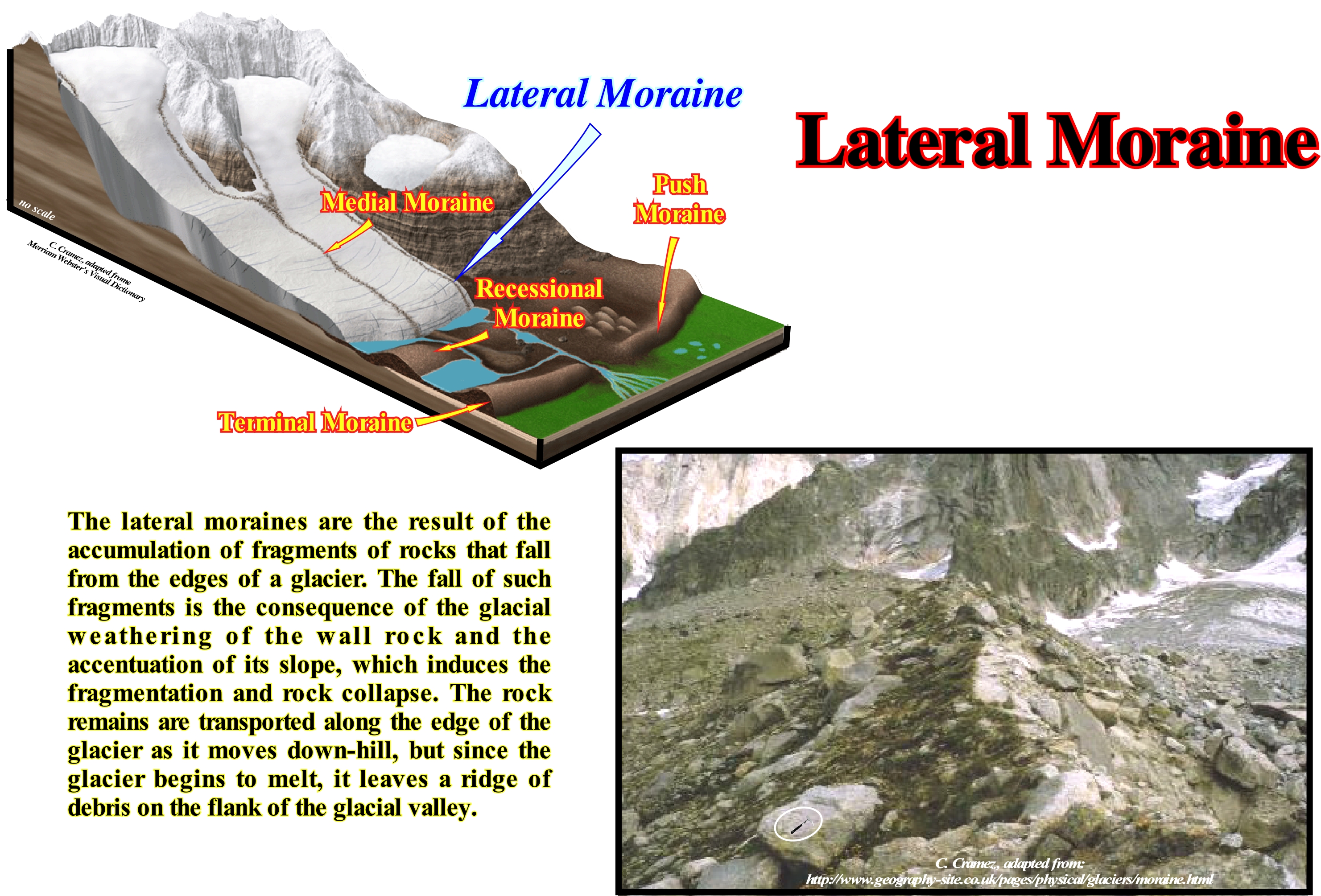
This photograph illustrates an abandoned lateral moraine as a consequence of the thinning (retreat) of the glacier. Along a glacier there are always two lateral moraines, one on each side, as the name implies, which means lateral moraines form at the edges of the glacier. As the glacier thickens (advances), the material on the valley walls, which fractures under the influence of temperature variations, falls to the glacier surface and is transported along the edges of the glacier. When the ice melts, a long cord of sedimentary particles appears on the slopes of the glacier valley. It may be said lateral moraines are small mounds of till (un-worked and non-layered sediments deposited directly by or under a glacier and not reactivated by melting glacial waters) deposited along the glacier sides. The nu-consolidated sedimentary particles resulting from the glacial abrasion of the valley walls and streams that flow into the main valley are deposited on the surface of the glacier and transported along the glacier banks until it melts. As the lateral moraines are deposited on the surface (top of the glaciers), they do not undergo the post-glacial erosion that occurs in the bottom of the valley. When the glacier melts, and disappears, the lateral moraines are preserved in the form of mounds, more or less, elevated. When two glacier, with their respective lateral moraines, converge the adjacent lateral moraines form, by juxtaposition, the medial moraine of the new glacier. The opposing lateral moraines form the lateral moraines of the new glacier. Examples of this type of confluence can be observed in most alpine glaciers, but the most illustrative examples are found in Alaska and Greenland, such as the formation of the medial moraine of the Edward Bailer glacier in East Greenland (Milne Land). Do not forget that the types of moraines that create topographic landforms are: (i) Lateral moraines; (ii) Medial moraines ; (iii) Ground moraines ; (iv) Frontal moraines ; (v) Recessional moraines ; (vi) Push moraines and (vii) Terminal moraines.
Lateral Reflection............................................................................................................................................................................Réflexion latérale
Reflexão Lateral/ Reflexión lateral (sísmica) / Side-Reflexion (seismische) / 侧反射(地震) / Латеральное отражение / Riflessione laterale (sismica) /
Reflection induced by organized energy not produced by reflectors located in the vertical plane of the seismic profile. The lateral reflections constitute an important difficulty in the geological interpretation of the seismic data, in particular if the geoscientist in charge of the interpretation does not have at his disposal all the seismic lines of a region.
See: « Acoustical Impedance »
&
« Parasite (reflection) »
&
« Seismic Reflection »
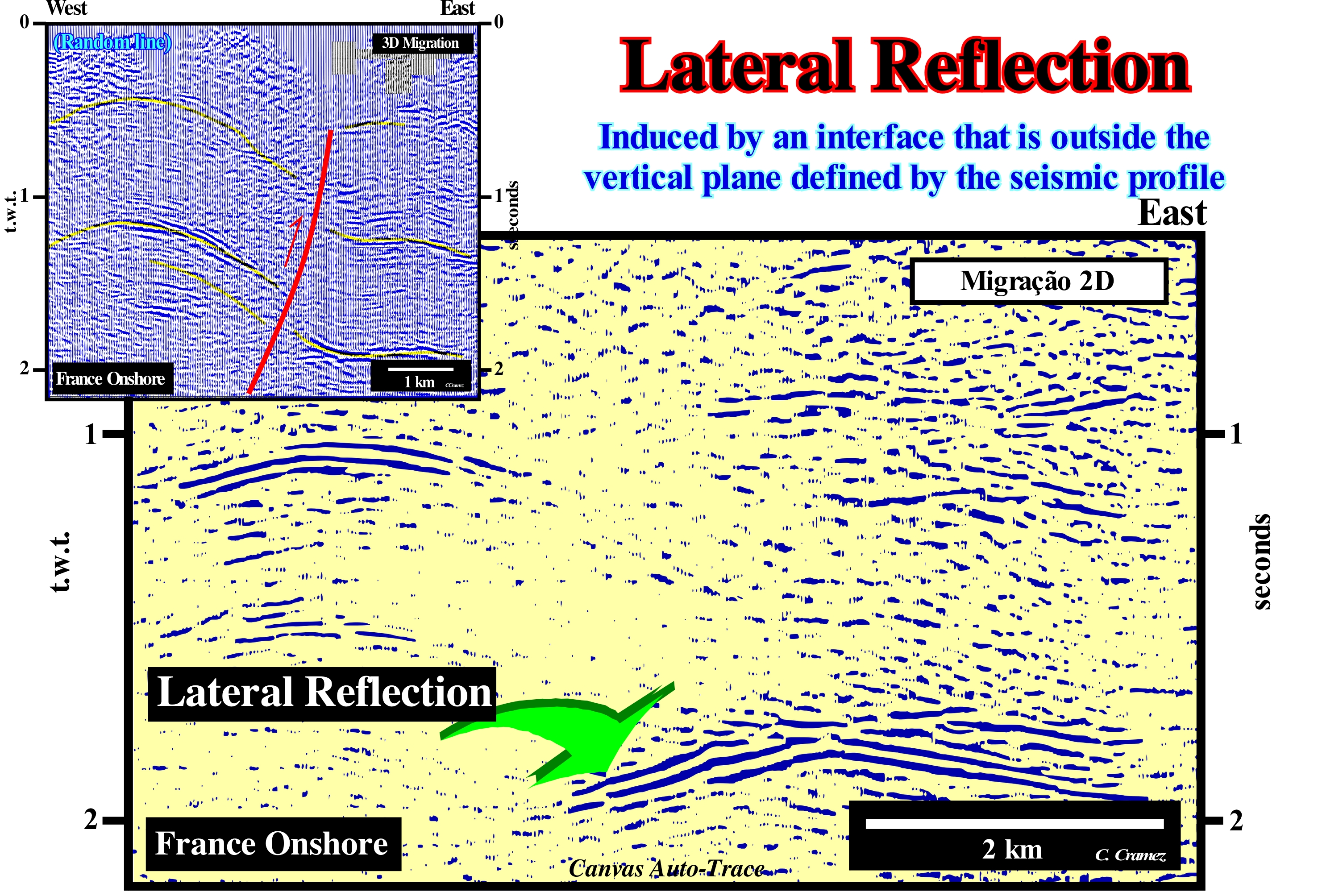
Each system of reflections can show areas of continuity and sectors where they are confused. Without further evidence, one can not tell which of the continuous reflections that are associated with others, or say, from what direction they come from. Sometimes, the examination of other seismic lines, better oriented, in relation to the structure of the rocks forming the ground, can allow the geological interpretation of complex lines with lateral reflections coming from several directions. On this Canvas auto-trace of a France onshore seismic line, the reflector underlined by the arrow was, initially, interpreted as a reflection induced by the plane of reverse fault. Sometimes, but rarely, fault planes are underlined by a seismic reflection: (i) When the fault zone (zone between the two failed blocks) is injected by salt, which is very frequent in basins with important evaporite intervals (onshore and offshore Angola, Lusitanian basin, etc) ; (ii) When the fault zone is injected by volcanism, as in certain areas of the North Sea and (iii) When the fault plane separates faulted blocks with highly contrasted acoustic impedances*, such as when a fault is defined between a basement (high impedance) and a sand-shale interval (low impedance). The interpretation of the reflection illustrated in this auto-trace as induced by the plane of an inverse fault is compatible with the geological context in compression of the area where the line was drawn. However, it is difficult to imagine, along the fault plane, an impedance contrast so localized between the faulted blocks. As every tentative interpretation has to be subjected to falsification tests (refutation), the conjecture of a reflection induced by a fault plane was refuted by an arbitrary 3D seismic line* passing through the original line. The reflection is lateral, which means that it has no geological significance, which is not the case with other reflectors, which underline chronostratigraphic lines.
(*) Acoustic impedance measures the opposition that a system presents to the acoustic flow resulting of an acoustic pressure applied to the system. Sound travels through materials under the influence of sound pressure. Because molecules or atoms of a solid are bound elastically to one another, the excess pressure results in a wave propagating through the solid. The acoustic impedance (Z) of a material is defined as the product of its density (p) and acoustic velocity (V): Z = pV (https://www.nde-ed.org/EducationResources/CommunityCollege/Ultrasonics/Physics/acousticimpedance.htm)
(**) Vertical seismic section along a line across a 3D data volume that is not necessarily straight or in in-line or cross-line directions. Also called user line, arbitrary line, and random line (which it is in no sense random).
Lateral Resolution (Seismic).....................................................................................................................................Résolution laterale
Resolução lateral (sísmica) / Resolución lateral (sísmica) / Laterale Auflösung (seismische) / 横向分辨率(地震) / Боковые разрешение (сейсмическое) / Risoluzione laterale (sismica) /
Minimum distance between two interfaces, more or less, vertical to obtain, on a seismic line, two different and non-continuous reflective events. Minimum lateral separation between two events from which the identity of events is lost.
See: « Seismic Resolution »
&
« Seismic Reflection »
&
« Fresnel Zone »

The lateral resolution is determined by the radius of the Fresnel zone, which itself depends on the wavelength of the seismic signal* and the depth of the reflector. In the same way, that light from a pocket lamp propagates in the dark and illuminates a particular sector (circle or ellipse), seismic energy propagates through wave fronts across the ground and comes in contact with reflective interfaces in certain sectors called Fresnel zones. In non-migrated 2D seismic lines, the lateral resolution depends on: (i) The space between the seismic traces** ; (ii) The length of the migration operator (Kirchhoff migration***) ; (iii) The seismic bandwidth (bandwidth is defined as the difference between the upper and lower usable frequencies) ; (ii) Interval velocity and (iii) The propagation time to the reflector. The problem of line orientation in relation to true dip is solved only in 3D lines. In the example illustrated above, the difference between two versions of the same 2D seismic line, with different lateral resolutions, is obvious. The exploration well found 10 meters of sandstones with oil in the bottom of the well, which are covered by a marine shaly interval that precedes a thick regressive interval. On the left line, which is a 2D line, with a frequency between 45 and 50 Hz, the only thing that can be said is the 10 m of sandstone found in the bottom of the well are, probably, associated with the reflective event that can be followed in continuity between 1.27 and 1.28 milliseconds. In contrast, in the right-hand line, which is the same as the left, but in which lateral resolution was reinforced, not only is the reflective event no longer continuous, as was the case previously, but several progradational (inclined) reflective events to the west can distinguish. Moreover, any aggradation is evident, i.e., that within the reservoir interval, the progradation are oblique. It can be hypothesized that the reservoir interval is composed of a set of progradational sand-bodies dipping westward, which may correspond to the top lines of the beaches created by tidal deltas (for instance).
(*) The seismic signal radiated from a source, be it an explosion or a shear rupture, is, usually, a more or less complicated displacement step function or velocity impulse of finite duration from milliseconds up to a few minutes at the most. A seismic signal recorded as a function of time can be represented equivalently in the frequency domain by its Fourier spectrum. The amplitude and phase spectrum are both needed to provide the complete time series. (http://gfzpublic.gfz-potsdam.de/pubman/item/escidoc:4017:4/component/escidoc:4018/ Chapter_4 _rev1.pdf)
(**) A seismic trace represents the response of the elastic wave-field to velocity and density contrasts across interfaces of layers of rock or sediments as energy travels from a source through the sub-surface to a receiver or receiver array (https://www.glossary.oilfield.slb.com/en/Terms/s/seismic_trace.aspx)
(***) Uses the integral form (Kirchhoff equation) of th wave equation, i.e., the mathematical expression to represent wave displacement and wave velocity (V) as functions of space (x, y, z) and time (t). V2ψ = ∂2ψ/∂x2 + ∂2ψ/∂y2 + ∂2ψ/∂z2 = (1/V2) ∂2ψ/∂t2, where ψ = wave displacement ; V = wave velocity; x, y and z = space coordinates; t = time.
Lateral Sedimentation.................................................................................................................................Sédimentation latérale
Sedimentação Lateral / Sedimentación lateral / Seitliche Sedimentation / 横向沉降 / Латеральная седиментация / Sedimentazione laterale /
Deposit of sedimentary particles on an inclined surface, migrating in a certain direction, as more sediments settle, as i is the case, for instance, the deposition on the convex side of the channel in a meandering plain.
See: « Sediment Influx »
&
« Depositional Model (sand-shale) »
&
« Relative Sea Level Change »
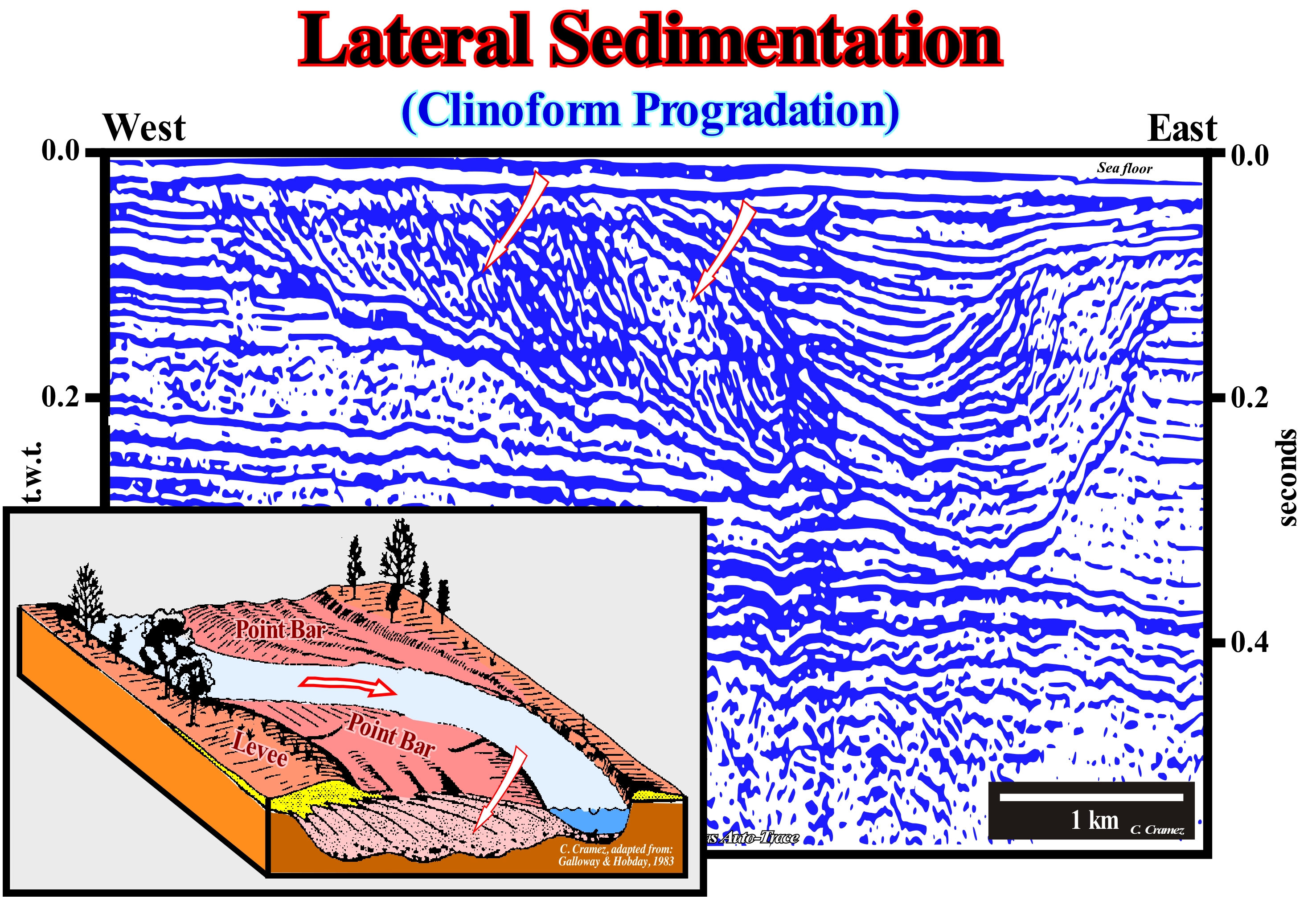
This Canvas auto-trace of a detail of US offshore seismic line illustrates, perfectly, a lateral sedimentation in an alluvial plain point-bar. This type of sedimentation exists, also, in the valley meanders (incised meanders), but is much more marked in alluvial plain meanders. This detail, which does not require any interpretation, corroborates the geological model of a point-bar proposed by Galloway and Hobday (1983), in which a meandriform river represents a balance between the effects of friction and inertia of the flow and the natural tendency that a runoff must always follow the shortest and highest dip path. In areas that are not rich in sedimentary particles, the rivers tend to form channels, in which the fastest flow is located in the central part as if the channels were rectilinear. When the channel is curved, as it almost always happens, the inertia pushes the faster flow zone against the concave bank, which is eroded forming an erosional bank. This erosional bank is, easily, recognized on this auto-trace, not only because it opposes the point-bar, but also by the onlaps that fossilize it. In the convex meander bank, as the water flow is weak (loose water), a part of the transported sedimentary particles deposits, laterally, forming the point-bar. Erosion on the concave bank and deposition on the convex bank forces the bed of the river to migrate towards the concave bank until a meander path is formed, i.e., a direct passage of the current between two non-consecutive concave banks, which isolates the point-bar between the two concave benches forming a meander lake in the central part of the abandoned channel. As can be seen on this auto-trace, the geometric relationships between the different clay-plugs (clay deposits deposited by decantation in an abandoned meander lake) that fossilize the channel, translate the history of abandonment of the main river bed, which, in this in particular case, has taken place in successive phases and not in just one step. At least five clay plugs can be evidenced by the geometrical relationships between the reflectors forming them. In sequential stratigraphy, which is, fundamentally, based on the identification and mapping of erosional surfaces induced by relative sea level falls* (unconformities), the identification of river valley fills and, in particular, incised-valley fills is quite important. In fact, on the seismic lines the identification of the unconformities is not always evident, particularly, when they are not tectonically enhanced (angular dislocations). It is in these cases that the identification of the incised-valley and canyons fills is very useful. It allows locating, locally, the unconformity that can then be picked, more or less, in continuity. In coastal sediments, quite often, a stacking of layers result from lateral rather than vertical sedimentation, since the rate of lateral migration of coastal sedimentary environments (spits, bay bottom, tidal marsh, etc.) allows the built of vertical a succession of continuous and overlapping horizontal layers. In marine sediments, lateral sedimentation is often taken as synonymous of progradation of the shoreline, whereas vertical sedimentation suggests, in most cases, a aggradation, i.e., a relative sea level rise (marine ingression) with a landward displacement of the shoreline. However, in detail, the accommodation created by the marine ingression is filled during the stability period of relative sea-level occurring after each sedimentary regression (lateral sedimentation). Thus, transgressions that, globally, have a aggradational/retrogradational geometry, which seems to correspond to a vertical sedimentation, are, in fact, a set of increasingly important marine ingressions and increasingly smaller sedimentary regressions. In other words, the layer stacking is the result of lateral sedimentation.
(*) Sea level can be of two types: (i) Relative sea level, which is the local and referenced to any fixed point on the Earth's surface, whether can be the base of the sediments (top of continental crust) or the sea floor and (ii) Absolute (eustatic) sea level, which is supposed to be global and referenced to the Earth's centre (presently, NOAA, i.e., the National Oceanic and Atmospheric Administration, uses satellite altimetry that must be calibrated by corrected tide-gauge results, i.e., taking into account the subsiding and uplifting site areas). The relative sea level is the result of the combined action of absolute (eustatic) sea level and tectonics (subsidence or uplift of the sea floor). The absolute sea level is the result of the combination of: i) Tectono-Eustasy that is controlled by the volume variation of the ocean basins in association with oceanic expansion following the break-up of the supercontinents ; (ii) Glacio-Eustasy, which is controlled by the variation of water volume of the oceans as a function of the amount of ice (assuming that the amount of water in all its forms is constant since the Earth's formation about 4.5 Ga) ; (iii) Geoidal-Eustasy, which is controlled by the distribution of ocean water caused by variations in the Earth's gravity field (where gravity is stronger than normal, sea level is thrown to the centre of the Earth) and (iv) Steric sea level rise or thermal expansion of the oceans, which is controlled by rising ocean temperatures (if the temperature increases, the density of water decreases and, for a constant mass, the volume increases).
Latitude.................................................................................................................................................................................................................................................Latitude
Latitude / Latitud / Geographische Breite / 纬度 / Широта / Latitudine, Latitudine geografica /
Distance (in degrees) from a point located on the surface of a planet to the equator, which means that the latitude can be either north (when the point is in the northern hemisphere) or south (when the point is placed in the southern hemisphere).
See: « Longitude »
&
« Earth »
&
« Map Projection »
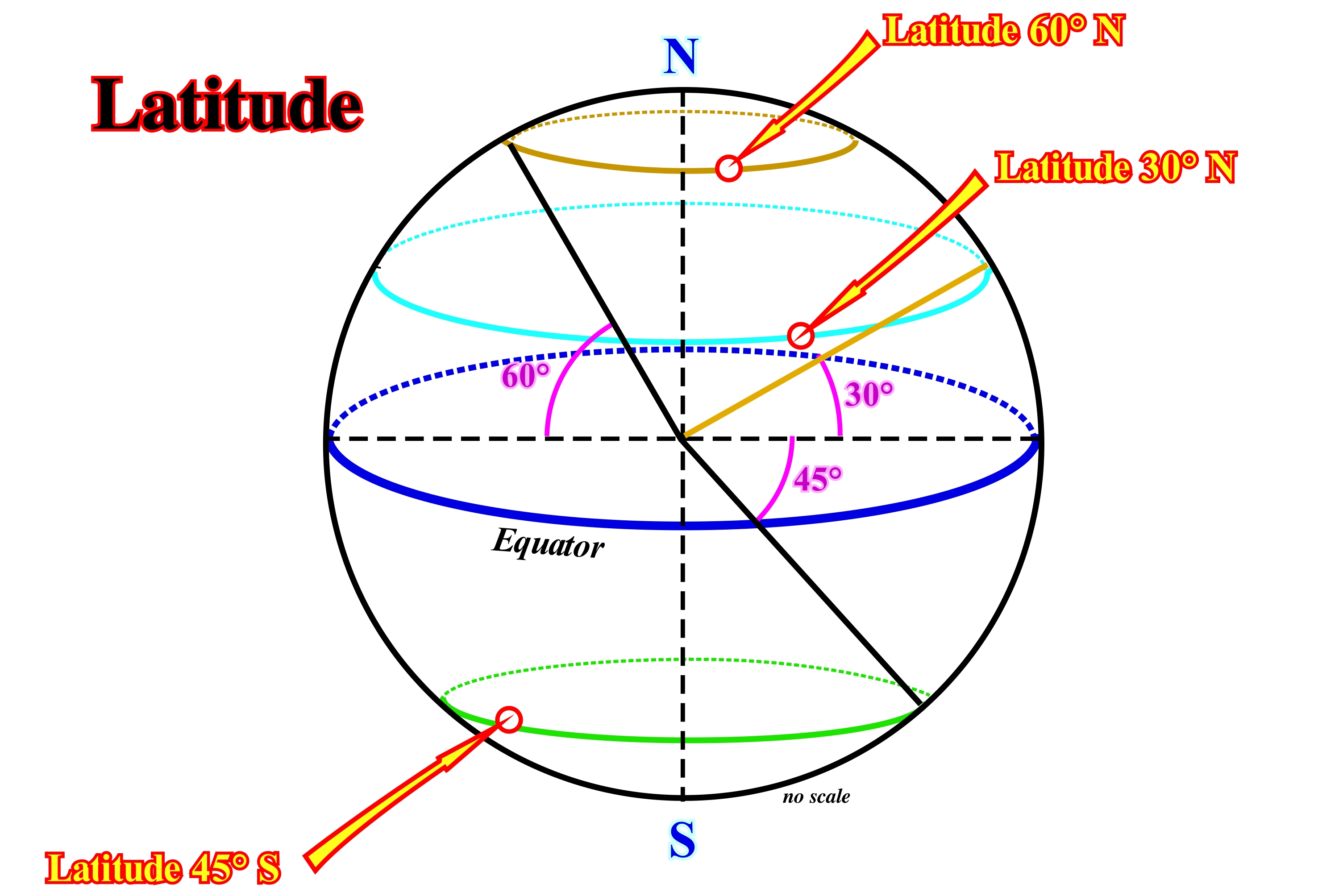
Latitude is the geographic or geodesic coordinate defined on the sphere (it expresses any horizontal position on the planet through two of the three coordinates in a spherical coordinate system, aligned with the axis of rotation of the Earth) on the reference ellipsoid or on the Earth's surface, that is the angle between the plane of the equator and the angle to the reference plane. The latitude is measured north and south of the equator, between 90° south, at the South Pole (Antarctic Pole, negative latitude), and 90° north, at the North Pole* (or the Arctic Pole, positive latitude). The latitude at the equator equals 0°. The way latitude is defined depends on the used reference surface : A ) In a spherical model of the Earth, the latitude of a place is the angle that the radius passing through that place makes with the plane of the equator, since the radius of curvature of the sphere is constant (this quantity is also equal to the angular measurement of the meridian arc between the equator and the place) ; B) In an ellipsoidal model of the Earth**, the latitude of a place (geodesic latitude) is the angle that the normal to the ellipsoid in that place makes with the plane of the equator (unlike what happens with the spherical model of the Earth, the normal to the ellipsoid in the various places are not all competitors in the centre of the Earth, on the other hand, and because the meridians are not circumferences but ellipses, latitude can not be confounded, as in the sphere, with the angular measurement of the meridian arc between the equator and the place; the latitudes of the places represented in the maps are geodesic latitudes) ; C) At Earth's surface, the latitude can also be defined as the angle between the vertical of the place (i.e., the direction of the plumb line) and the plane of the equator. Since the vertical of the place does not coincide, usually, with the normal to the reference ellipsoid** in that place, this mode of latitude (astronomical or natural latitude) is, generally, different from the latitude mapped on the geodetic latitude. Long before the shape and dimensions of the Earth were accurately known, astronomical latitude was already determined by observing the stars, using quadrants, astrolabes, and balestilhas (http://en.wikipedia.org/wiki/Latitude).
(*) Defined as the point in the Northern Hemisphere where the Earth's axis of rotation meets its surfaces surface. The sea depth at the North Pole is 4,261 m ( Russian Mir submersible, 2007). The nearest land is usually said to be Kaffeklubben Island, off the northern coast of Greenland about 700 km. The nearest permanently inhabited place is Alert in the Oikiqtaalik Region, Nunavut, Canada, which is located 817 km (508 mi) from the Pole. (https://en.wikipedia. org/wiki/North_Pole).
(**) Since the Earth is flattened at the poles and bulges at the equator, geodesy represents the figure of the Earth as an oblate spheroid. The oblate spheroid or oblate ellipsoid, is an ellipsoid of revolution obtained by rotating an ellipse about its shorter axis. It is the regular geometric shape that most nearly approximates the Earth's shape. A spheroid describing the figure of the Earth or other celestial body is called a reference ellipsoid. The reference ellipsoid for Earth is called an Earth ellipsoid. (https://en. wikipedia.org/wiki/Figure _of_the_Earth).
Laurasia (Small supercontinent)............................................................................................................................................................................Laurasia
Laurasia / Laurasia / Laurasia / 劳亚大陆 / Лавразия / Laurasia /
A small northern supercontinent of the supercontinent Pangea, formed by agglutination of the Paleozoic continents during the second phase of the continental encroachment cycle after the supercontinent Proto-pangeia (Rodhinia). Laurasia was more or less separated from the small southern supercontinent of Pangea (Gondwana) by the Tethys Sea.
See: « Supercontinent »
&
« Pangea »
&
« Gondwana »
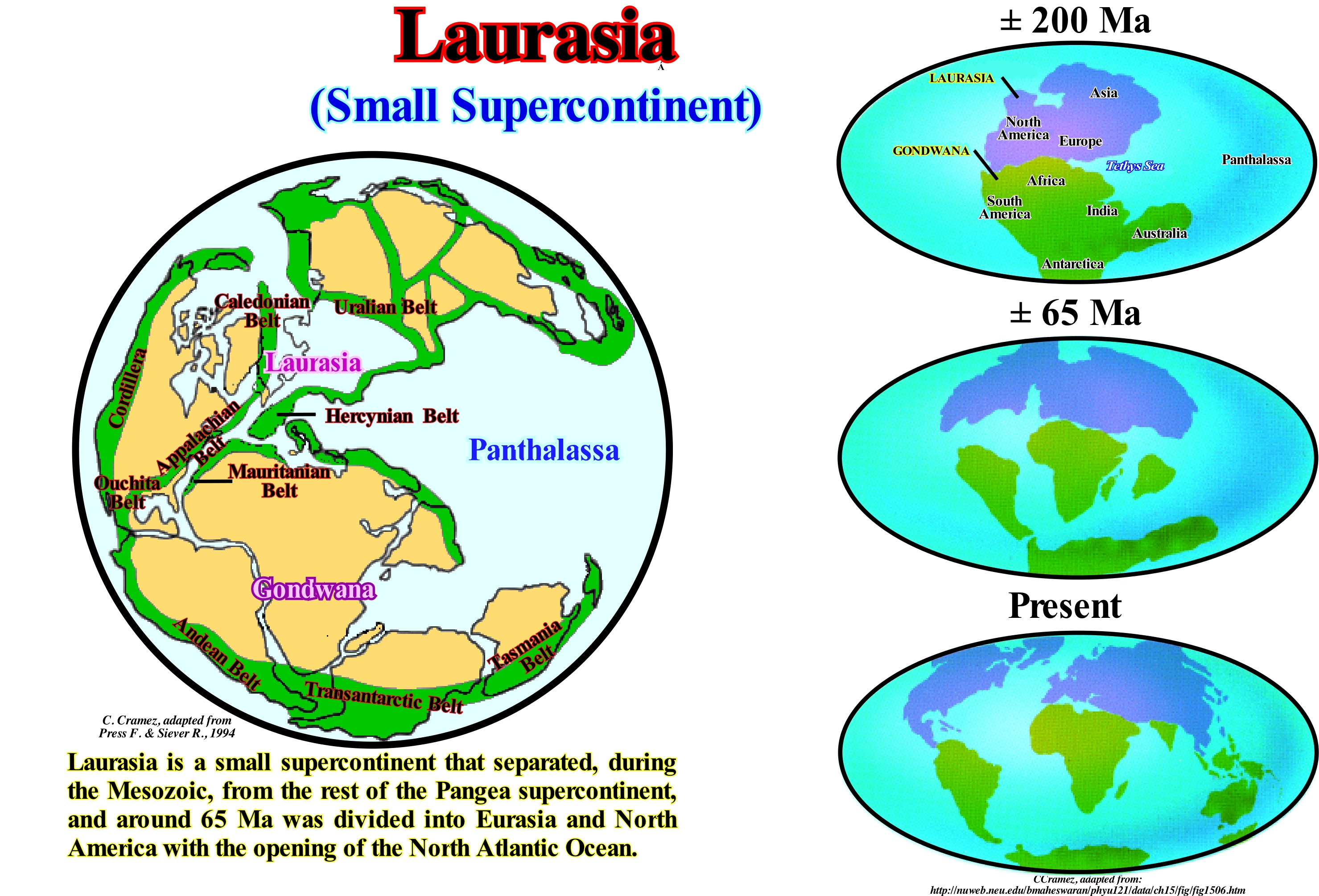
Laurasia is a small supercontinent that separated, during the Mesozoic, from the south of the supercontinent Pangea, which was renamed Gondwana. About 65 million years ago, Laurasia (not to be confused with Laurussia* which is a continent of the Devonian, which predates the formation of Pangea) was divided into two great continents: (i) Eurasia and (ii) America North, at the same time as the North Atlantic Ocean was formed. Most geoscientists agree on the hypothesis that at the end of the Paleozoic: (i) The terrestrial lithosphere consisted of a limited number of lithospheric plates, possibly one ; (ii) In the middle of a great and unique ocean, called Panthalassa, a great supercontinent, called Pangea, was formed by the agglutination of the Paleozoic continents ; (iii) The Pangea supercontinent was flanked everywhere by mountain ranges, associated with convergent margins, except in the eastern part, where there existed a great gulf (Paleo-Tethys ocean**), which underlined a divergent continental margin ; (iv) In the northern part of Pangea, the small supercontinent Laurasia (sometimes considered as a continent), was composed of the old mountain ranges (Ural, Caledonian, Appalachian, Ouachita and Hercynian) ; (v) In the southern part of the supercontinent Pangea, was located the small supercontinent Gondwana, in which the only major central mountain range was that of Mauritania. The Andes folded belt, the Transantarctic belt (sub-divides the Antarctic continent into an eastern and a western region, stretching for more than 3,200 km from Victoria Land to the shores of the Weddell Sea) and the Tasmania belt are peripheral mountain belts and, locally, more recent. The supercontinent Pangea, like all other supercontinents, marks the end of a tectono-sedimentary cycle, whose time-duration varies between 200 and 300 My. On the basis of Plate Tectonics Theory*** and assuming that the volume of water in all its forms is constant since the Earth's formation (4.5 Ga), such a cycle can be summarized as follows: (a) When the number of lithospheric plates is very small (supercontinent), the sea level (distance between the sea surface and a reference point) is very low (the ocean basins volume is very large since the oceanic ridges volume is small) ; (b) When the supercontinent breaks-up, the individualized continents disperse and the absolute (eustatic) sea level (supposed global and referenced to the Earth's centre) rises encroaching the continents, since the volume of the oceanic basin decreases (large volume of the oceanic mountains, i.e., large volume of the ocean ridges) ; (c) From the moment that the continents can not move more farther apart (the Earth is spherical), they begin to approach each other to finally come together ; (d) This collision type, in which kinetic energy plays no role, creates not only a new supercontinent, but a new mountain belt as well ; the absolute (eustatic) sea level falls as the volume of the oceanic basins increases (the oceanic ridges volume is at its minimum). In this evolution, the term collision which in ordinary language corresponds to a transformation of the kinetic energy into deformation energy, as, for example, when a car comes against a wall, is used here just by an inherited language pattern. In fact, as said above, in Plate Tectonics, kinetic energy plays no role. All rocks of a lithospheric plate are submitted to the same tectonic vector (σt). However, locally, they can be deformed where they lost the resistance to deformation, i.e., they yield, which happens when they are subjected to high temperatures and pressures.
(*) Laurussia, continent of old red sandstones or Euramerica, was a small supercontinent that formed in the Silurian following the collision between the continents Laurentia, Baltica and Avalonia (Caledonian orogenesis), which encompassed what is today called North America and Northern and Eastern Europe.
(**) The supercontinent Pangea was a land mass with a "C" shape looking eastward. Inside the "C" was the Paleo-Tethys Ocean. Two micro-continents, which are now part of China, were located in the northeast around the Paleo-Tethys Ocean. However, about 300 million years ago, a rifting began in East, which separated a thin arch from the interior of the southern arm of Pangea. The new micro-continent, which geoscientists called Cimmeria, included what it is today Australia, Antarctica, Indian sub-continent and Africa-Arabia. Behind this new micro-continent a new ocean began to form, called Tethys Sea (or Neo-Tethys Ocean), which was enlarged as the Cimmeria moved northward to Laurasia closing the Paleo-Tethys Sea. It can be said that the Cimmeria was an ancient micro-continent separating the ancient Paleo-Tethys and Neo-Tethys oceans.
(***) The basic principle of Plate Tectonics is the existence of a lithosphere consisting of separate and distinct tectonic plates floating on the asthenosphere. The relative fluidity of the asthenosphere allows the tectonic plates to move in different directions. The lithospheric plates contact each other along the plate boundaries, which are commonly associated with geological events such as earthquakes and the creation of topographic elements such as mountain ranges, volcanoes and oceanic trenches. Most of the world's active volcanoes are located along the plate boundaries, with the Pacific Fire Circle being the most well-known and active zone. (https:// pt.wikipedia.org/wiki/Tect%C3%B3nica_de_placas).
Laurentia......................................................................................................................................................................................................................................Laurentia
Laurência / Laurencia / Laurentia (Kontinent) / 勞倫大陸 / Лауренция (континент) / Laurentia /
Continent resulting from the rupture of the Precambrian supercontinent (Proto-Pangeia or Rodhinia). The main northern continents of the Proto-Pangeia were Baltica (Finoscandina or Fenoscandia) and Laurentia, which incorporated much of what is now North America. Due to the enlargement and rupture of the southern part of the Proto-Pangeia, Laurentia migrated, slowly, northward. During Cambrian and Ordovician, Laurentia was located near the equator and covered by shallow seas, in which trilobites and other marine life types flourished. At that time, the southern margin of Laurentia had a paleo-latitude of approximately 15-20 ° S.
See: « Supercontinent »
&
« Pangea »
&
« Gondwana »

The paleogeography of the Late Cambrian, illustrated in this figure, suggests that most of the continents individualized by the break-up of the supercontinent Proto-Pangea (also called Rodhinia), were located in the southern hemisphere, at low paleo-latitudes. When this supercontinent fragmented, the small supercontinent Gondwana, and the continents Laurentia, Baltica, and other submerged Asian blocks became individualized. In the Cambrian, the Laurentia continent was located near the equator and was, partially, submerged by the Iapetus Sea*, while the Baltica and the Siberia were, progressively, approaching. The Gondwana small supercontinent has, always, remained the largest of the land masses resulting from the break-up of the supercontinent Pangea. The other land masses were mainly Kazakhstan and China (present-day China, Thailand, Malaysia and Indochina). The seas were shallow, especially, along the edges of the continents, which means that most of the sedimentary basins had a continental shelf. Marine ingressions, induced mainly by absolute (eustatic) sea level** rises that accompanied the dispersion of the continents (volume decrease of the ocean basins to an amount of water admitted as constant) occurred in the Middle and Late Cambrian. The transgressions (set of marine ingressions and associated sedimentary regressions) created shallow seas around the continents, creating a habitat favourable to marine life. As illustrated in this paleogeographic sketch, these shallow epiric seas*** (epicontinental) covered most of the continents except the Gondwana small supercontinent, where the mountainous regions predominated (eastern Siberia and central Kazakhstan). The evolution of Laurentia, from the Proterozoic till the formation of Pangea, can be summarized as follows: A) Around 1.9 Ga, Laurentia was formed by agglutination of the various cratons (Wyoming, Hearn, Rae, Slave, etc.) and by the accretion of lands such as the Mojave Desert by a series of orogenies during the gathering of the Nuna supercontinent ; Columbia or Hudsonia, which was one of the first supercontinents recognized by paleomagnetic data, seems to have existed between 1, 5 to 1.8 Ga, during the Paleoproterozoic era ; it left craters found on Laurentia and Baltica continents, as well as in Ukraine, Amazonia, Australia and perhaps in Siberia, Northern China and Kalahari Desert ; B) Between 1.8 Ga and 1.6 Ga occurred the accretions of Mazatzai and Yavapai (Arizona Proterozoic geological provinces between 1.7-1.6 Ga and between 1.8-1.7) ; (iii) From 1.1 Ga to 0.75 Ga, Laurentia was part of the supercontinent Rodhinia (Proto-Pangea), of which it is the centre situated near the equator ; (iv) From 0.75 Ga to 0.60 Ga, Laurentia drifted southward with Siberia, Baltica, Amazonas, West Africa and the Rio de la Plata craton ; (v) About 0.6 Ga, Laurentia was part of the supercontinent Pannotia around 60° South ; (vi) From 0.57 Ga to 0.44 Ga, Laurentia was an individualized continent that drifted northward and reached the equator in the Silurian ; (vi) About 0.47 Ga, the southern coast of Laurentia collided with the Taconic island arc ; (vii) From 0.44 Ga to 0.41 Ga, Laurentia collided with Baltica and Avalonia to form the Laurasia continent, closing the Iapetus Sea forming the Caledonian mountain belt ; (viii) From 0.34 Ga to 0.27 Ga, the Laurasia continent, of which Laurentia was a part, collided with the small supercontinent Gondwana forming the supercontinent Pangea and the Hercynian mountain belt.
(*) The Iapetus Sea, which existed between 600 and 400 Ma, between the Neoproterozoic and Paleozoic, was formed after the separation of Protolaurasia (an ancient small supercontinent that was part of two previous supercontinents, Rodhinia and Pannotia). In the southern hemisphere, this ocean was located between Laurentia (Scotland, North America and Greenland) at the West, the Baltica (Scandinavia and Eastern Europe) at the East and Avalonia (United Kingdom, north-western Europe) at the South, plus other emerged smaller land masses (that are today part of New England, Nova Scotia and Acadia) situated westward of Avalonia.
(**) Supposed global sea level referenced to the Earth's centre, which is dependent on Tectono-Eustasy, Glacio-Eustasia, Geoidal-Eustasy and Steric sea level rise or Thermal Expansion of the oceans.
(***) Seas differ from the oceans by size and geographical location. Seas are parts of the shallower oceans located between continental boundaries. Due to the reflection of the sky, temperature of the water, or presence of coloured sediments or substances on the sea floor, the colour of the seas varies between blue, green and dark grey, depending always on the speed and intensity of the wind. The oceans are divided by the mid-oceanic ridges, which form the submarine mountain ranges extending over 65,000 km in length with an average height of 2.5 km above the surrounding sea floor. (http://www.sitedecuriosidades.com/ curiosidade/diferencas-entre-mar-e-oceano.html)
Lava Delta.........................................................................................................................................................................................................................Delta de lave
Delta de lava / Delta de lava / Delta de lava / 熔岩三角洲 / Лавовая дельта / Delta di lava /
Delta similar to the delta of a river that forms when significant flows of subaerial lava (volcanic flows) enter bodies of stagnant water or not. The lava, when entering a waterbody, cools, breaks and solidifies, filling the topography of the sea floor constructing a rocky body, more or less, progradational (delta lava).
See : " Tephrachronology"
Law of Sigmoidal Growth (Carbonates)..............................Loi de la croissance sigmoïdal (Carbonates)
Lei do crescimento sigmóide / Ley de crecimiento sigmoidal (carbonatos) / Gesetz der sigmoidale Wachstum / 法S形增长 / Закон S -образного роста / Legge di crescita sigmoidale /
When the initial growth (of any set) is exponential, for later (competition or scarcity) to decrease becoming null, in a maturation phase. This type of function was, initially, studied by the Belgian mathematician Pierre François Verhulst who deduced it from the population growth.
See: « Logistic Curve »
&
« Depositional Model (carbonates) »
&
« Systems Tract »

As suggested in this sketch of coral reef progradation, many carbonate systems are controlled by the growth of organisms, which follows the law of sigmoid growth as a function of time. As many geoscientists think, a population of organisms responds to the creation of a new space to live in three stages: (i) Growth, with the creation of a new space; (ii) Growth, which exceeds the space creation rate and (iii) Growth, limited by the space creation rate. All populations have characteristics that can be determined statistically (size, density, growth rate, mortality rate, immigration, emigration, etc.). When conditions are ideal, a single species of a population will increase in a geometric progression at a rate that is specific to the genotype of the species (elemental genetic composition of an organism with respect to one or more characteristics that determine the transmission of the same characteristics). Contrary to this potential growth, the population also has its own capacity for death, which is reinforced and determined by the environment, i.e., that all population evolves according to its size, rate of growth, persistence, evolution and extinction. It was P. F. Verhulst (1838), who first discovered the law of population growth by formulating the differential equation that includes the instantaneous growth rate (dN / dt) of an organism in a limited environment. Such growth is inhibited by the increase in the number of organisms. When projected onto a graph (as illustrated above), this equation is called sigmoid or logistic. Several geoscientists used this equation to determine the growth of a number of populations over time, such as that of yeast cells, which starting from 9 units, after 18 hours, the number of cells increases to 661 following an S-curve or sigmoid growth curve.
Leachate.................................................................................................................................................................................................................................................Lixiviat
Lixiviado / Lixiviado / Sickerwasser / 渗滤液 / Продукт выщелачивания / Percolato /
Solution produced by leaching, i.e., by dissolving and transporting the soluble components of rocks or from a discharge zone (site for the disposal of waste by burial, which is the oldest and most polluting form of waste treatment).
See: « Diagenesis »
&
« Leaching »
&
« Rock Cycle »
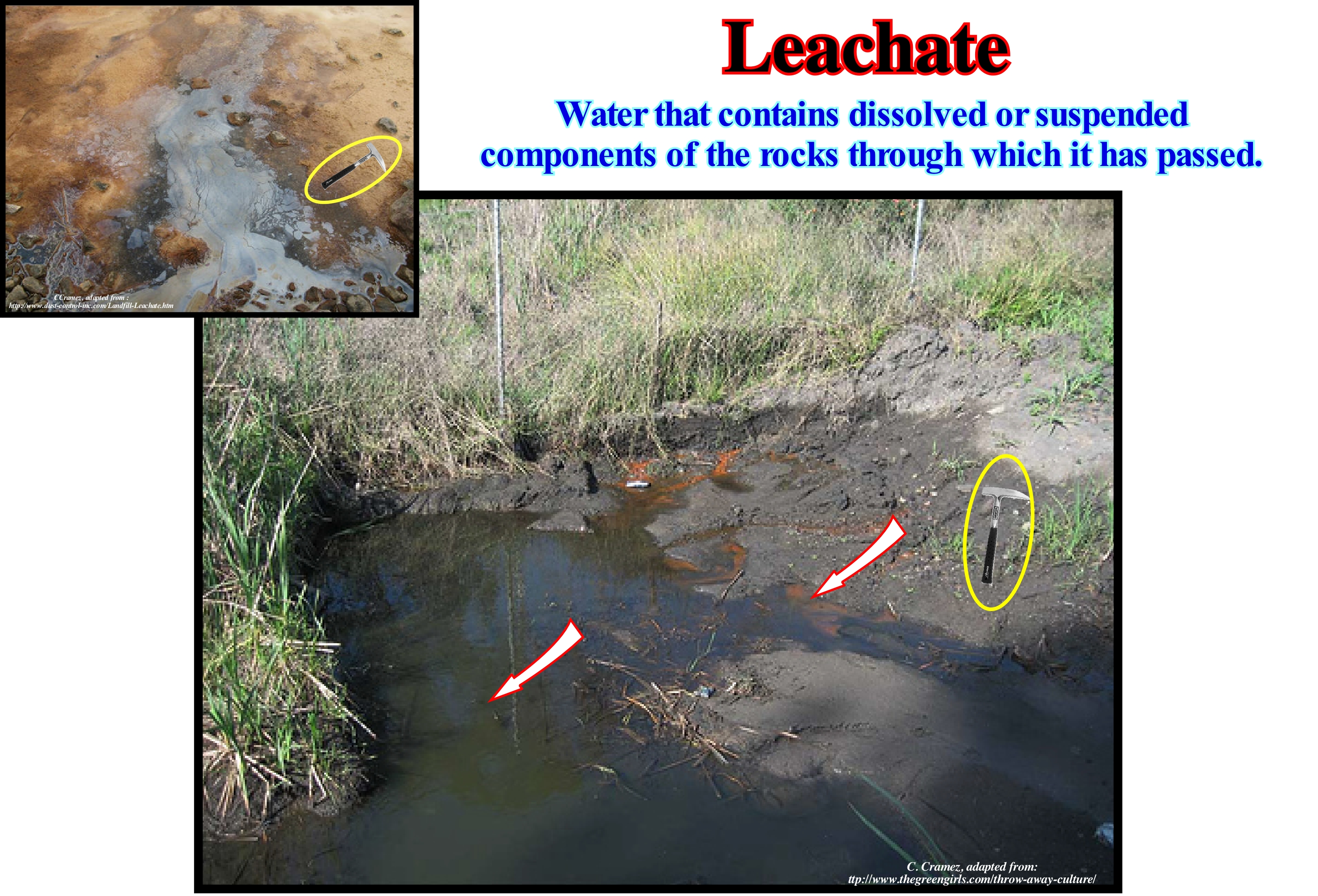
As illustrated in this example, rain-water, snow, and even fog can dissolve certain minerals from rocks, especially those that dissolve easily, in acid solutions, and form leachates, which flow downhill the coast. During the runoff, certain minerals may precipitate from the leachate, but when it is discharged into the water streams, which become polluted and unfit for consumption. The most polluting leachates are anthropogenic, particularly, those created by municipal waste and discharges. Once the garbage is left outdoors, it decomposes and rain-water or snow seeps through it becoming, heavily, contaminated (dissolution of various substances). Since the water escapes from the discharge, it forms a leachate. The decomposition of carbonaceous material, which produces a wide variety of products such as methane, carbon dioxide, organic aldehyde acids (derived from a primary alcohol by loss of hydrogen), alcohols, sugars, etc. greatly enriches the leached composition. When water percolates* through the garbage, it promotes, and helps, the decomposition produced by the action of bacteria and fungi. These types of decomposition release by-products and consumes, rapidly, the available oxygen, which creates an anoxic environment, increasing the temperature and decreasing the pH. In this manner, many metal ions which were insoluble at a neutral pH, dissolve thereby increasing the concentration of the leachate. In addition, the decomposition processes also release water, which increases the volume of the leachate. On the other hand, the leachate also reacts with materials that have little tendency to decompose, such as ashes and cement-based building materials, changing their chemical composition. Therefore, when garbage contains gypsum-based building materials, the reaction of the leachate with the gypsum produces large amounts of hydrogen sulphide (H2S).
(*) Percolation is the action or process of passing liquid through interstices.
Leaching.......................................................................................................................................................................................................................................Lixiviation
Lixiviação / Lixiviación / Versickerung / 浸出 / Выщелачивание / Lisciviazione /
Process by which water dissolves and transports the soluble components of a rock.
See: « Diagenesis »
&
« Leachate »
&
« Rock Cycle »
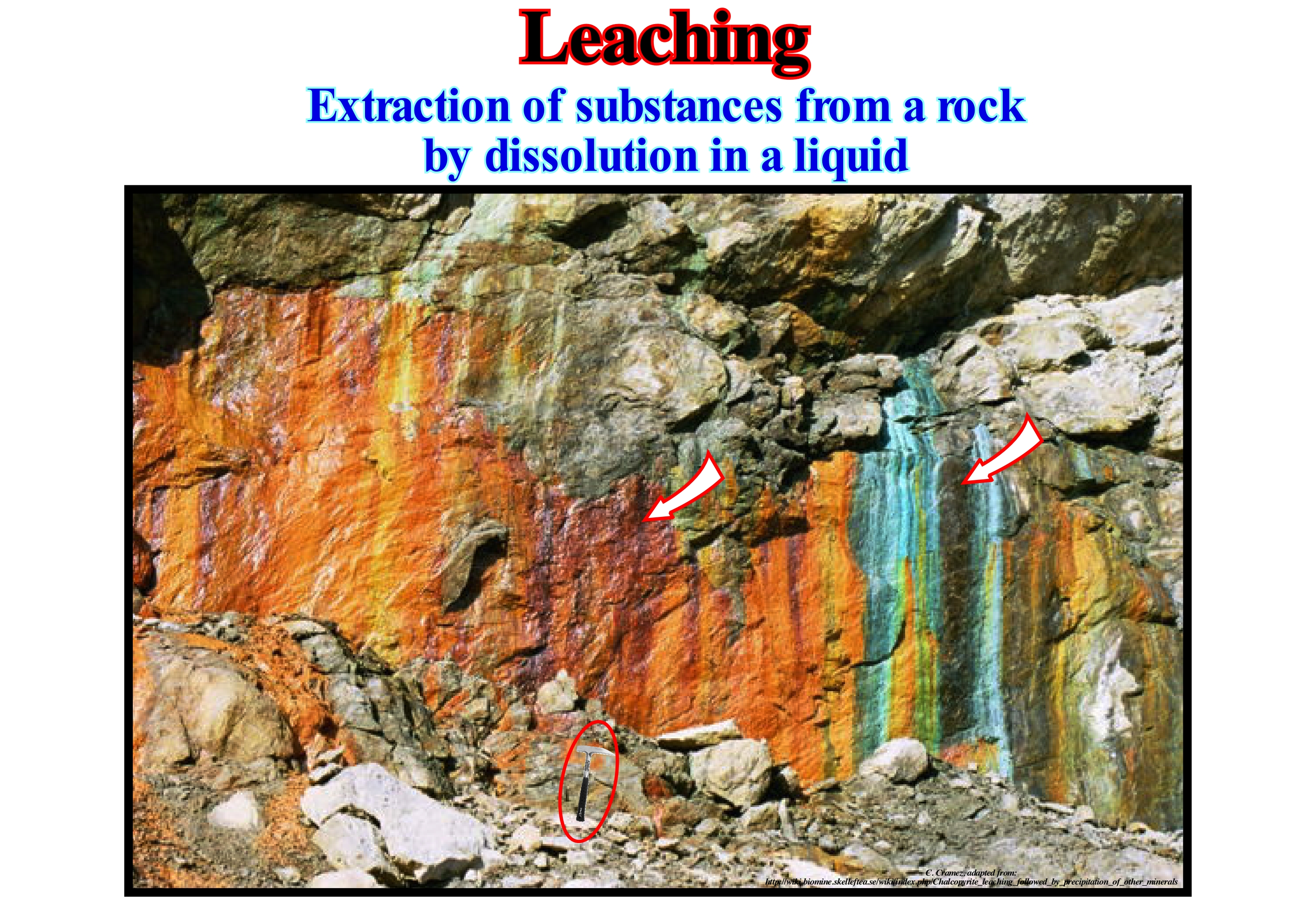
In a particular rock, the conditions necessary for the leaching (dissolution and transport) and precipitation (sequestration) of a mineral, such as chalcopyrite (CuFeS2), are that it is in direct contact with the pyrite (FeS2), which can be oxidized by rain, snow or fog and form dilute sulfuric acid. The sulfuric acid will leach, i.e., dissolve and transport copper (Cu) from the chalcopyrite to precipitate it as chrysocolite {(Cu,Al)_2 H2Si2O5 (OH)4 nH2O} or malachite {Cu2 CO3(OH)2}. This precipitation occurs as long as the pH (acidity or basicity of a solution) becomes neutral, which happens when the pyrite is leached by rain, snow or fog, and transported downhill (provided that the pyrite is not oxidized during transport ). Precipitation can be influenced by the presence of small carbonate horizons of the rocks along which the solution flows. If the solution passes through a carbonated horizon, the sulfuric acid will be neutralized and malachite is deposited. Since atmospheric air contains carbon in the form of carbon dioxide (CO2), an oxidation with oxygen and carbon dioxide (O2 + CO2) and also with carbon monoxide (CO), which can produce a small layer of malachite and/ or azurite. In the pedology (study of soils in their natural environment), the leaching corresponds to the loss of mineral and organic solutions by percolation, i.e., by flow and filtration of the solutions through a porous material, as the flow of petroleum through the fractures of a rock. This mechanism of soil production is very different from the other mechanism of production, which is eluviation (removal of materials from soils and geological horizons), which is characterized by the loss of organic and mineral colloids (chemical mixture where a substance is evenly distributed, dispersed in another). The leached and eluvialized materials in the upper part of the soils, where there is a high concentration of organic matter and micro-organisms and most of the biological activity of the soils, are deposited underground, forming an illuviation zone (deposit of the material transported through of a soil) above the substrate, which may be an exogenous or endogenous rock. In geology, the material removed is irrelevant and the deposit (eluvial deposit) is the remaining material.
Leeward Platform Margin..................................................................................Marge de la plate-forme (Sous le vent)
Margen de plataforma (sotavento) / Márgen de plataforma (sotavento) / Margin-Plattform (Lee) / 保证金平台(背风) / Окраина платформы (в подветренную сторону) / Margine piattaforma (sottovento) /
Margin of a carbonated platform that is oriented towards the dominant wind (leeward margin). In relation to the windward carbonated bmargins where active reefs are frequent, on the leeward margins, the reefs are buried, as the wind transports the sediments to the edge or even out of the bank or the carbonate platform.
See: « Rimmed Carbonate Platform »
&
« Reef »
&
« Deposition (carbonates) »

The carbonate platforms, which are not connected to the continent, present very important variations not only in the geometry, but also in the facies (lithology and fauna), as a function of the surrounding oceanographic conditions. Several studies, particularly those conducted in the Caribbean Sea, have shown that there is a large difference between the carbonated banks of windward (side of the platform receiving the wind or side where the wind blows) and of leeward (margin opposite to the side where the wind blows or direction to where the wind blows). The dynamics and preservation of the sediments is very different if the carbonate margin facing the wind (windward margin) or if it is oriented towards the wind (leeward margin). The former have a relatively low sedimentary particles influx, since the particles are largely transported to the platform, that is, opposite the margin, whereas in the second the sedimentary particle influx it is important and often fossilized the reefs. The leeward banks are, more or less, oriented towards the dominant wind. They are, largely, protected from the action of the waves, in which three cases can be considered: (i) Very agitated sea, when the erosive action of the sea waves reaches about 50 m of water-depth or more, particularly, during heavy storms ; (ii) Agitated sea, when the erosive action of the waves reaches a depth of about 30 meters, which means that the distance between two successive waves (distance between two crests or two consecutive troughs) is about 60 meters, i.e., half of the wave-length ; (iii) Calm sea, when the erosive action of the sea-waves reaches, more or less, the depth of 10 meters. This last wave action depth corresponds, approximately, to the position of the depositional coastal break of the deposition surface (roughly the shoreline on seismic lines). The open margins receive the sedimentary particles produced on the platform during periods of rough seas and storms. In general, they are characterized by important carbonate sand deposits, which, often, fossilize the reefs that can flourish during periods of relative sea level lower than the bank that does not have great terrigeneous influx, since accommodation is negative. Protected margins are not influenced by waves or sedimentary particles. Therefore, they are characterized by fine reef horizons and hardened surfaces with little sediments. An important distinction with respect to sedimentary particles transport along the leeward margins is the presence of barriers (against the transportation of the sedimentary particles) across the platform, which may be either islands or emerging reefs. On the contrary, on the windward banks, i.e., on the banks oriented against the wind or in side from where the wind blows, the sedimentary intervals are progradational, thick and of more important lateral extension, as it can be seen in the geological sketch illustrated in this figure. In most carbonated margins the tide's influence is small. There are different types of carbonated platforms: (i) Rimmed Platforms, with reefs or reefal shoals on the edge of the platform ; (ii) Ramp-type platforms, with carbonated sands at the shoreline and clay sands and deep-water mud at the base of the ramp (reefs are not important) ; (iii) Epeirial (or epíric) platforms, which are characterized by the presence of tidal surfaces and protected lagoons ; (iv) Isolated Platforms, in which the lithologies are controlled by the orientation of the winds (they have reefs and sandy bodies in the windward margin, but in the leeward margin, the sediments are more muddy) ; (v) Dead or Drowned Platform, when the platform is (was placed) below photic zone (whose depth varies greatly depending on the turbidity of the water). The platforms connected to the mainland are often divided into two large families: (A) Flat-Topped Platform and (B) Ramp-Type Platforms. On flat-topped platforms (A) there are o two sub-types: (A.1) Rimmed and (A.2) Nonrimmed. In ramp-type platforms (B) two sub-types can be considered: (B.1) Distally Steepened and (B.2) Homoclinal. The platforms connected to the mainland are often divided into two large families: (A) Flat-Topped Platform and (B) Ramp-Type Platforms. On flat-topped platforms (A) there are o two sub-types: (A.1) Rimmed and (A.2) Non-Rimmed. In ramp-type platforms (B) two sub-types can be considered: (B.1) Distally Steepened and (B.2) Homoclinal. The carbonated platform illustrated in the photograph of this figure is probably a ramp-type platform (B) of the monoclinal sub-type (B.2). According to some geoscientists, this type of platform seems to be more frequent when the processes of carbonate manufacture are in cold water. When carbonate manufacturing processes are associated with tropical climates, carbonate platforms are usually either rimmed (A.1) or non-rimmed (A.2), or they correspond to mounds of mud without rupture zone.
Lenghtening (Rifting, Wilson's cycle)...........................................................................................................................Allongement (rifting)
Alongamento (Riftização) / Alargamiento (rifting) / Verlängerung / 延长 / Удлинение / Estensione (rifting) /
Second tectono-stratigraphic phase of the Wilson's cycle cycle, in which there is formation of rift-type basins (usually half-grabens with opposite vergence on each side of the central thermal anomaly). The tectono-stratigraphic phases of a Wilson's cycle are: (i) Stable Continental Craton ; (2) Thermal Anomaly (hot spot) and Lengthening (i.e., extension) ; (3) Rupture (break-up) of the Lithosphere, with creation of new oceanic crust and formation of two divergent margins ; (4) Sea Floor Spreading (ocean expansion), which, progressively, transforms young divergent margins into old margins, due to the cooling and increasing density of the oceanic crust ; (5) Subduction, since the density of the oceanic crust is very large enough, it splits in two portions and one of them dives under the other creating a convergent margin and forming a volcanic arc and uplift a mountain chain on the overriding plate lithospheric ; (6) Divergent Margin/Volcanic Arc Collision and formation of a mountain range ; (7) Peneplanation and new subduction of the oceanic crust with the twin margin creating another convergent margin ; (8) Continent/Continent Collision and closure of the ocean formed between the two primeval divergent margins and (9) Formation of a new Stable Continental Craton.
See: « Wilson's Cycle »
Lentic (Water)......................................................................................................................................................................................................................Lentique (Eau)
Lentique (eau) / Léntica (agua) / Lentic (Wasser) / 静水(水)/ Стоячая (вода) / Lentica (acqua) /
Static fresh-water that, theoretically, does not flow away. A body of lentic water can have any size from a puddle, after the last rain, to the size of Lake Baikal, which is the deepest fresh-water lake in the world with 1,620 meters deep. Contrary to lotic water.
See: « Lotic (water) »
&
« Stream »
&
« Lake »
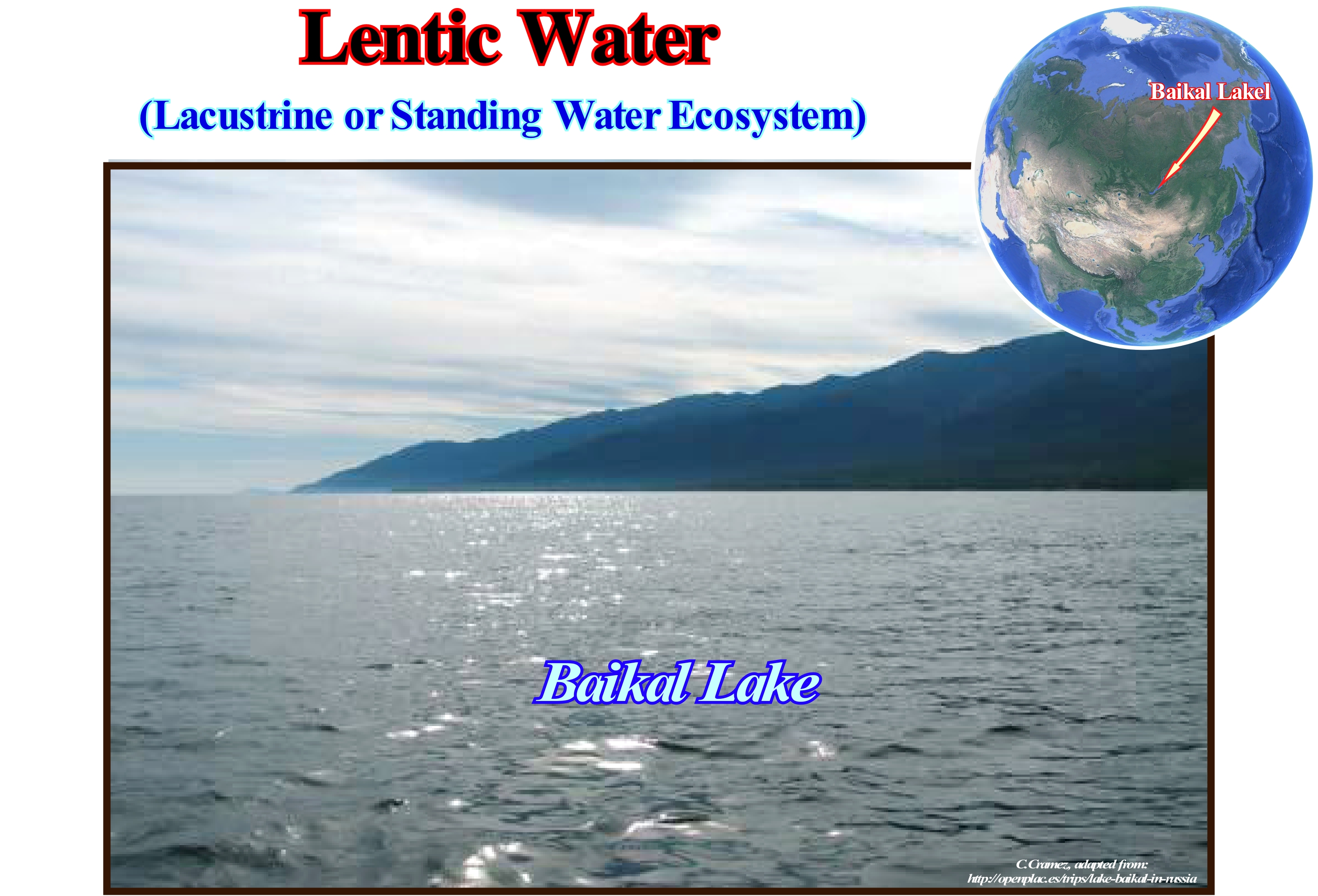
The term lentic refers to stagnant water. A lentic ecosystem runs from a small pond or swamp to a huge lake. A lentic ecosystem is the ecosystem of a pond (extensive but not deep puddle), lake, swamp or lake and includes biotic interactions between plants, animals and micro-organisms, as well as, abiotic physical-chemical interactions. Lentic ecosystems can be compared to lotic ecosystems, which include the flowing terrestrial waters such as rivers and water streams, etc. These two types of ecosystems form the most general area of study of fresh-water, i.e., aquatic ecology. The distinction between puddle, pond and lakes is very vague, although certain geoscientists consider that puddles and ponds all have their lower surface exposed to light, whereas lakes do not. Some lakes stratify during certain seasons. The puddles and ponds have two regions: (i) The open pelagic zone and (ii) The benthic zone, which includes the bottom and the banks. As lakes have deep regions not exposed to light, in relation to puddles and ponds, the lakes have an additional zone, which is the deep zone. These three areas: A) Pelagic zone ; B) Benthic zone and C) Deep zone, can have very different abiotic conditions and, therefore, the species that inhabit it are adapted, specifically, to live there. Lakes can be formed in many ways, but the largest and oldest system results from tectonic activity, during the break-up of supercontinents, that is, when they lengthen and form rift-type basins. When the extension rate is not compensated for by a sufficient filling rate, a water column naturally forms, since all the space available for the sediments is not filled, which creates a lake. Unlike if the sedimentary particle influx is sufficient to balance the extension rate, all accommodation is filled and no water column is formed. Most of the lagoons are of fluvial origin and associated with the abandoned meanders.
Levee...............................................................................................................................................................................................................................................................Levée (Dique naturelle)
Dique marginal natural / Dique marginal natural / Deich / 坝, 天然堤 / Природная плотина, насыпь / Argine, Argine naturale /
Sandbank and clay deposited along the banks of a river or a turbidite current. A levee, i.e., a natural marginal dike is constructed by the successive accumulation of small sedimentary bodies deposited when the current overflows the bed or the depression in which it flows. Levees are often, associated, with rivers, tides, but also with turbidite currents.
See: « Turbidite »
&
" Clay Plug "
&
« Overbank Deposit »
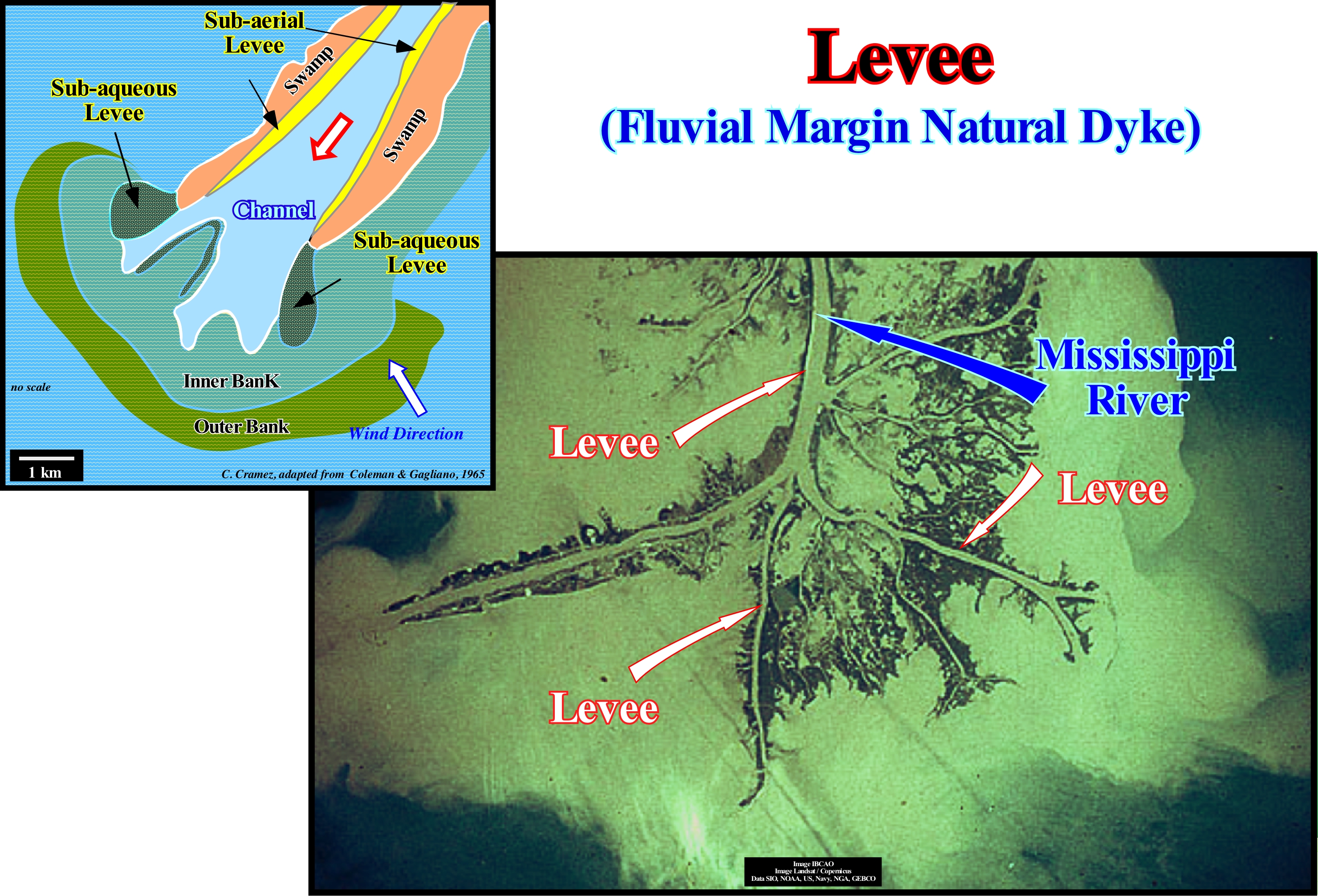
The deposits by vertical accretion are those that are formed, mainly, by the deposition of the sedimentary particles transported in suspension by the overbanking waters. In principle, all river deposits should be considered as vertical accretions, since they are deposited on pre-existing surfaces, but the terminology is above all based on floodplain* growths. Overbank deposits are constructed vertically in the floodplain, as opposed to the lateral growth of the banks (levees). Flood plains can be constructed vertically by: (i) Deposition of sedimentary particles (debris) carried along the beds or by wind deposits ; (ii) Mud flows ; (iii) Slippage and slumpings, etc. In general, the term vertical accretion is applied to aggradational processes occurring in the floodplain by depositing the normally fine sedimentary particles transported by the overbanking waters. The velocity of the overbanking waters, abruptly, decreases as they leave the main channel stream. The thicker and coarser vertical accretion deposits are those that form the natural marginal fluvial river dykes (levees) that border the channel. The largest vertical accretion deposits occur in the lower parts of the floodplain behind the natural marginal dykes (levees), that is, in the marshes, which are formed by stagnant and shallow waters, located on an impermeable horizon, with a quite dense vegetation and a soil with large amounts of decomposing organic matter. The swamps, i.e., flat areas with abundant herbaceous vegetation that remain flooded are, generally, formed where the water flow is slow, that is to say, in poorly drained plains (organic material present in water decompose in situ). Typically, marshes are located in the lower part of water-course and in coastal areas, but they may, also, occur in the high and medium parts of rivers. The passage from a levee (natural marginal dikes) into the marshes is very gradual and with no clear limit. Salt-water marshes, which certain geoscientists call coastal salt marsh or a tidal marsh, develop on the floodplain plains in coastal areas. They are subject to the same extremes of salinity, temperature and tides that affect tidal-flats and have muddy bottoms, whose mud is fixed by the roots of plants, and is therefore relatively stable. The vegetation of these marshes comprises few grasses (leafy plants resembling a blade, with hollow stems and very branched roots, such as garden grass, cereals, bamboos, etc.). The salt marshes located far from the sea, are located around lakes or salty lagoons. The plant composition and species diversity of a swamp is, strongly, influenced by its relationship with the closest ecosystems, which determine the amount of nutrients, water movement and the type and quantity of deposited sediments. In this sketch, typical of the Gulf of Mexico, are illustrated the natural sub-aqueous and under-water marginal dykes (levees) associated to a distributive of the Mississippi river, which are visible in aerial photography. Submarine natural marginal dykes limit the marshes. The internal bank (intensively worked by the action of the waves) and the external bank (worked only by the storm waves) are, easily, recognizable. Overbank deposits are also very frequent in turbidite depositional systems, especially, in the submarine slope fans where it forms the famous "gull wings" of P. Vail. Therefore, when a geoscientist speaks of natural marginal dykes, it is always important to specify whether they are fluvial or turbiditic natural margin dykes.
(*) Also called flood plain, which is all the region on the fringes of a water-course, which overbanks during the floods, developed over a valley filled with alluvium on which streams meander because of their low dip. In times of flooding, the streams overflow their original margins inundating the adjacent region.
(**) Flood is, usually, a natural situation of overflowing of water from its natural bed of a water-stream, usually, caused by heavy and continuous rains. The occurrence of floods is more frequent in occupied areas, when drainage systems become less efficient over time if they are not recalculated or properly adapted technically. A flood may be the result of a rain that has not been, sufficiently, absorbed by the soil and other forms of runoff, which causes overbanking, but may also have an anthropic origin (construction of dams, opening or breaking of dam sluices, etc..). For many geoscientists there is a conceptual distinction between flood and inundation. A flood refers to a natural occurrence which, normally, does not directly affect the population, in view of their cyclicity, whereas a inundation is due to changes in land use and can cause major damage.
Libra Point (Astronomy)......................................................................................................................................................................................Point Libra
Ponto Libra / Punto libra (astronomía) / Libra Punkt (Astronomie) / 天秤座点(天文) / Точка Весов (астрономия) / Punto Libra (astronomia) /
Intersection point of the ecliptic and the celestial equator, as the sun moves from the northern hemisphere to the southern hemisphere. The Libra point occurs in early autumn (September 21), in the northern hemisphere, when straight ascension and astronomical declination are zero. Opposite the Vernal Point or Aries Point.
See: « Ecliptic »
&
« Equinox »
&
« Precession »
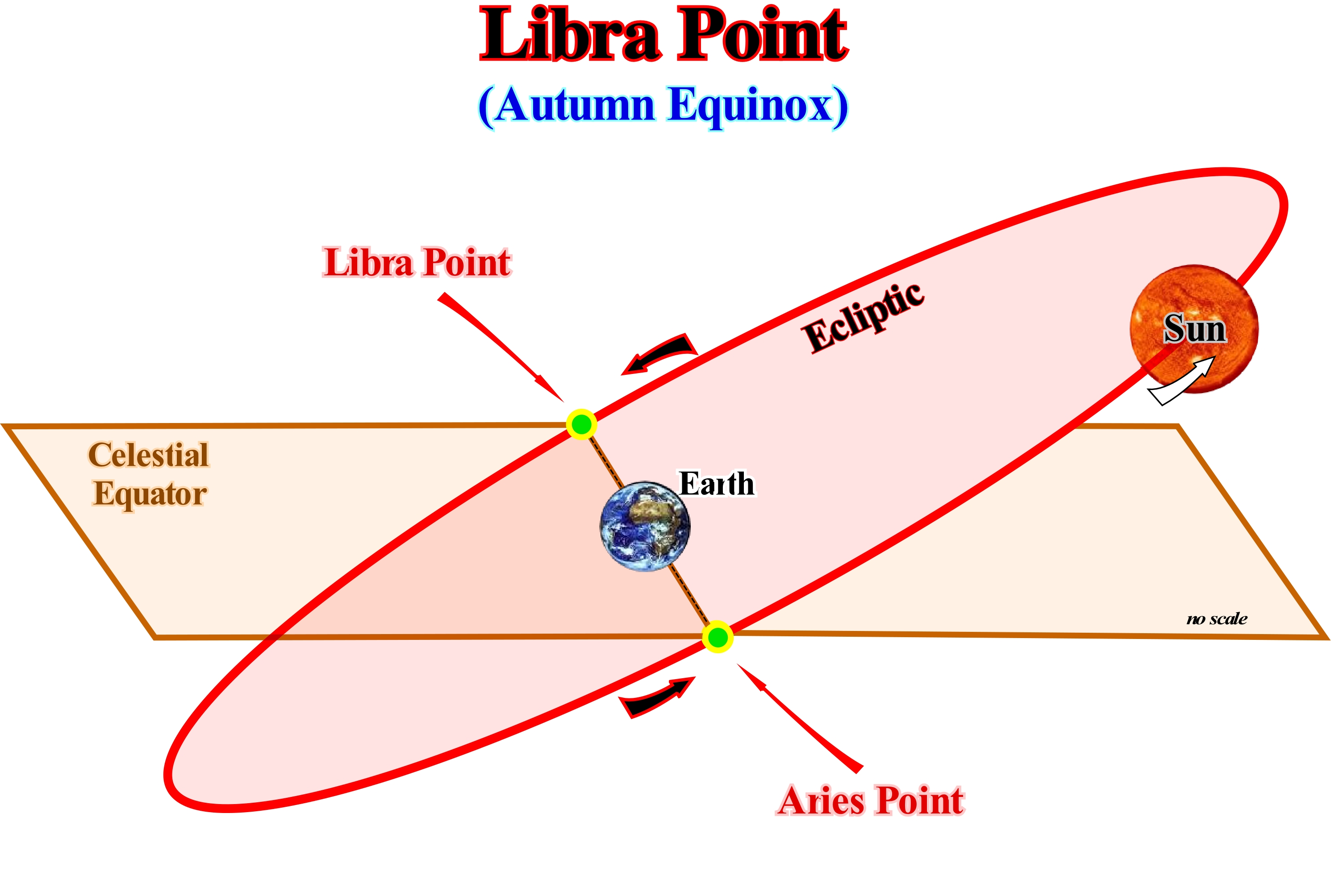
The Libra point, also called the point of the Autumn equinox, marks the beginning of Autumn in the northern hemisphere. This equinox occurs around September 22/24, varying a little each year according to the cycle of 400 years of leap years in the Gregorian calendar (the calendar that is, currently, used in the Western world). The Libra point is one of the two points on the celestial sphere, where the celestial equator intercepts the ecliptic. The name comes from the Libra constellation, in which it occurred in ancient times. Due to precession (change in the axis of rotation of an object), the Libra point, gradually, moves around the ecliptic. The opposite point, at the vernal or spring equinox, is the Aries point. When the Earth is up in the celestial equator, in the North hemisphere, the day is longer than the night, since the Earth is inclined on its axis in relation to the Sun. As the Earth does not only revolve around its own axis, but also orbits the Sun, on the equinoxes, i.e., at the Libra Point and the Aries Point, the Earth and the Sun are positioned in such a way that the line, on Earth, that separates night from day passes through both poles of the Earth, which means that the night has the same duration as the day. In the equatorial coordinate system, where the declination indicates the angular spacing of a star relative to the celestial equator and the right ascension indicates the angular spacing of a star's hourly semicircle in relation to the semicircle hourly of the vernal point, the Libra point is defined to have a straight ascension of 12 hours and a declination zero, due to the position on the celestial equator. In this coordinate system, also called Universal Equatorial System or Uranographic System, the polar distance is complementary of the declination, i.e. the sum of the both is 90°.
Life.......................................................................................................................................................................................................................................................................................Vie
Vida / Vida / Leben / 生活 / Жизнь / Vita /
There is no definitive definition of what life is. For science, a living being is something that satisfies a certain number of conditions. Thus, from the biochemical point of view, living beings are beings that contain reproducible hereditary information encoded in molecules of nucleic acids and that control the rate of metabolizing reactions by the use of catalysis with special proteins called enzymes. This definition is much more sophisticated than the metabolic or physiological definition. However, in this case too, there are counter-examples: there is a type of virus that does not contain nucleic acid and is capable of reproducing without the use of nucleic acid of the host.
See: « Organic Matter (types) »
&
« Theory of Evolution »
&
« Photosynthesis »
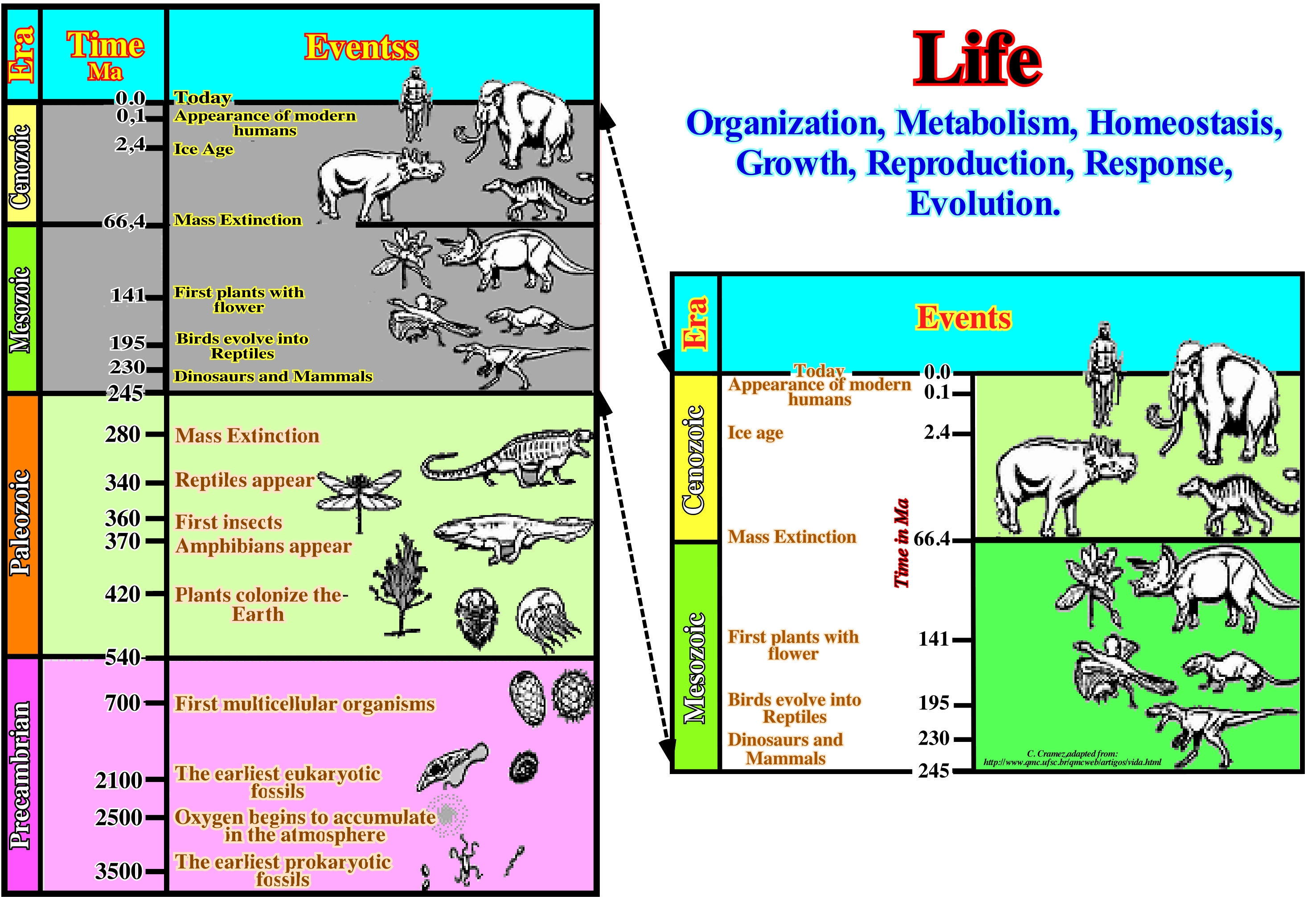
Locally, life violates the second law of thermodynamics, i.e., that it extracts energy from the environment and uses it to increase local order. This is because life corresponds to an open system. Simple as it may seem, it is still very difficult for scientists to define life clearly. Many biologists try to define it as a phenomenon that animates matter. Traditionally, an entity is considered to be a living being if it exhibits all of the following phenomena at least once during its existence: (i) Growth, i.e., production of new cells ; (ii) Metabolism, i.e., consumption, transformation and storage of energy and mass (growth by absorption and mass reorganization, excretion of waste) ; (iii) Movement, either its own movement or internal movement ; (iv) Reproduction, which means having the ability to generate entities similar to itself ; (v) Response to stimuli, or in other words, the ability to assess the properties of the surrounding environment and to act in response to certain conditions. These criteria have their utility, but their disparate nature renders them unsatisfactory under more than one perspective. In fact, it is not difficult to find counter-examples, as well as examples that require further elaboration. There is still no consensus model for the origin of life. Several hypotheses have been advanced. Living systems acquire and utilize the free energy they need to perform their various functions by combining the exoergic (work-producing) reactions of nutrient oxidation with the endoergic (labor-consuming) processes required to maintain the living state. (http://en.wikipedia.org/wiki/Vida).
Light Crude Oil.......................................................................................................................................................................................................Huile légère
Óleo leve (petróleo) / Petróleo liviano / Leichtöl 轻质油 / Дизельное топливо / Olio leggero /
Oil with a low content of wax. The differentiation between light and heavy oil is, purely, practical. A low viscosity oil is easier to pump and transport because it is lighter. Some geoscientists consider light oil as a synonym for Light Oil, which others do not consider very fair.
See: « Oil »
&
« Hydrocarbon »
&
« Source-Rock »

The formula for obtaining the API gravity of the liquid hydrocarbons, of specific gravity (SG), is: 141.5 / SG - 131.5. The API's (American Petroleum Institute) gravity of the oil determines whether a liquid oil is heavier or lighter than water. If the gravity or API grade is greater than 10, the oil is lighter than water. If the API density is less than 10, the oil is heavier than water and naturally falls to the bottom of the water. We can say API gravity is a measure of the density of a liquid oil in relation to water density, but in reality it is used to compare the relative densities of liquid oils. A light oil, as shown in this photograph, is a liquid oil having an API degree or gravity or above 40°. A light oil is an oil (flammable liquid found in rocks formed by a mixture of hydrocarbons of different molecular weight and other organic compounds) with a low content of wax. The price of a barrel of oil is, among other factors, a function of the API grade and the molecular characteristics of the oil. The main references of oil (petroleum) in commerce are: (i) "West Texas Intermediate" (WTI) of very good quality light petroleum, with less than 0.5% sulfur ; (ii) Brent Blend oil mixture from 15 North Sea fields (the price of oil from Europe, Africa, the Middle East is fixed on the price of the "Brent") ; (iii) Dubai-Oman, which is used as a reference for oil with more than 5% sulfur in the Middle East and sold in Asian countries ; (iv) "Tapis" from Malaysia is used as a reference for light oil in Asia; (v) Mines, Indonesia (Sumatra) oil, which is used as a reference for heavy oil in East Asia ; (v) "OPEC Reference Basket", which corresponds to the weighted average of oil blends from various countries of the Organization of Petroleum Exporting Countries. The oil of the world's largest oil field, Gahawar has a severity between 33° and 40° API.
Light Oil (Petroleum)...................................................................................................................................................................................................Huie légère
Óleo leve / Petróleo liviano / Light Crude Oil / 轻质原油 / Лёгкая (маловязкая) нефть / Greggio leggero /
Oil with a low wax content. Sometimes, considered as synonymous of Light Crude Oil. We reserve the term petroleum for a natural oil of mineral origin. The distinction between "light" and "heavy" oil is, purely, practical, since an oil with a low viscosity is easier to pump and transport because it is lighter.
See: « Oil »
&
« Hydrocarbon »
&
« Source-Rock »
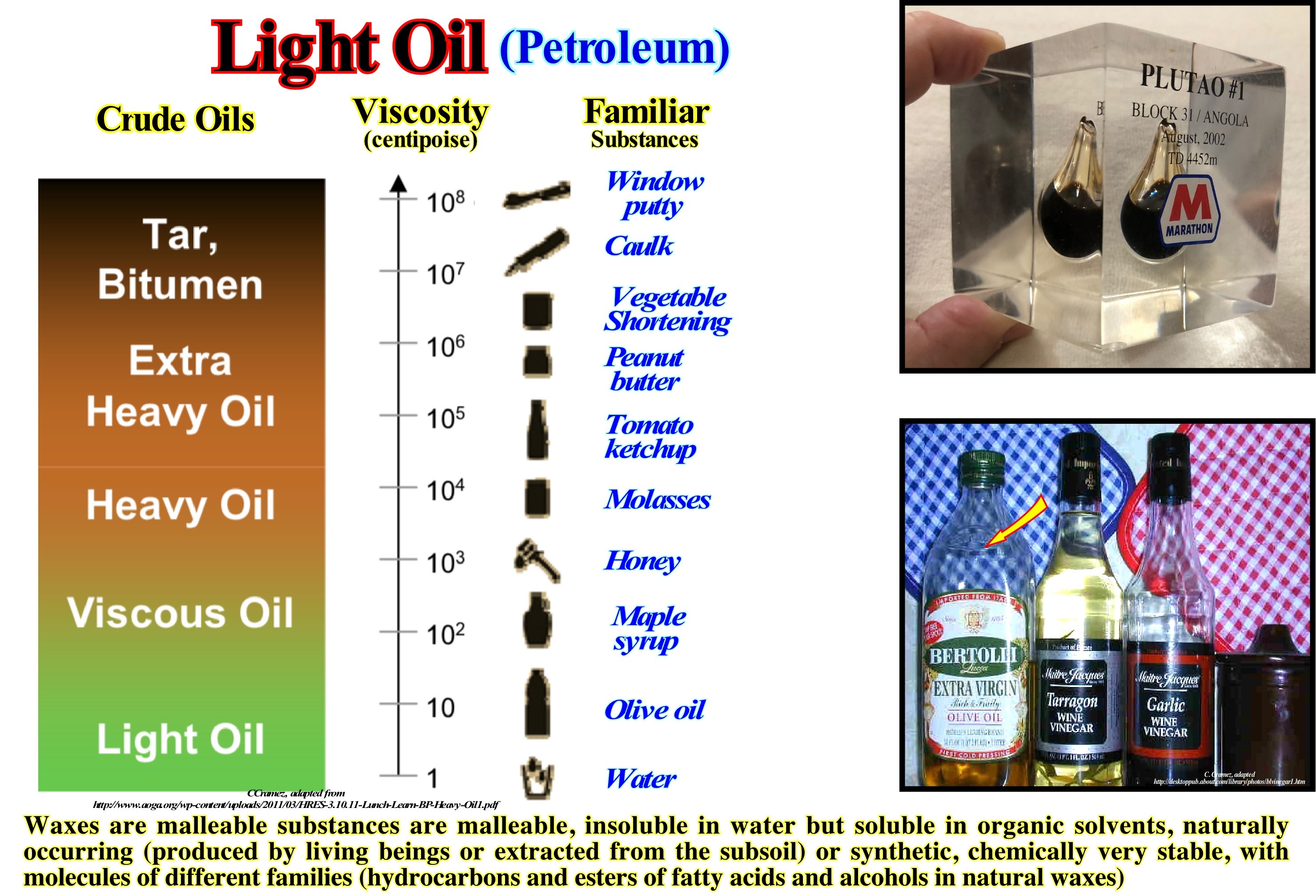
One of the most common light oils is olive oil, which, when good, has a low viscosity and low density. Portugal produces about 1% of world production (2005). On average, each Portuguese consumes 7 kg per year, which represents about 2% of the world consumption. Olive oil is produced by grinding the olives and extracting the oil by a mechanical or chemical means. The olives are ground using large grinding stones or steel cylinders. The ripe olives produce a bitter oil and the very ripe olives produce the rancid oil, which means that to obtain a good olive oil it is necessary to use perfectly ripened olives. As illustrated, to know what to buy we have to understand the meaning of the labels. In a supermarket, different labels can be found: (i) "Extra Virgin", which means simply virgin ; (ii) "100% pure olive oil", which means that it is the lowest quality olive oil available (the best must have "virgin" on the label); (iii) "Made from Refined Olive Oil" means that taste and acidity were chemically controlled; (iv) "Light olive oil" means olive oil with less flavour (all olive oil has 120 kcal / tbsp, i.e. about 34 kJ / ml); (v) "Hand-picked olive oil" means that the oil is of better quality, since producers who harvest olives by mechanical means tend to let the olives over-ripen to increase yield ; (v) "First Cold Milling" is a pure commercial word-of-mouth with no meaning (suggests that the oil in the bottles with this label is the oil that comes from the first milling and that no heat was used, which is incorrect, a time without the production of heat and cold) and does not define any precise temperature. However, according to European regulations, during grinding the temperature must always be below 27° C. In a well known crude oils classification, (i) Light Oil, with a viscosity* between 1 and 10 centipoise**, can be liken to water or olive oil ; (ii) Viscous Oil, with a viscosity around 102 centipoise, can be liken to maple syrup ; (iii) Heavy Oil, which viscosity ranges between 103 and 104, can be liken to honey and molasses ; (iv) Extra Heavy Oil, which porosity ranges between 104 and 106, is, often, liken with tomato ketchup or peanut butter and (v) Tar or Bitumen, which viscosity ranges between 106 and 108, is comparable vegetal shortening or window putty. In terms of API degree*** it can be said: a) Light oil bas an API gravity higher than 31.1 °API (less than 870 kg/m³) ; b) Viscous oil has an API gravity from 31.1 °API to 22.3 °API (870 to 920 kg/m³) ; c) Heavy oil has an API gravity from 22.3 °API to 10 °API (920 to 1000 kg/m³) ; d) Extra-heavy oil has an API gravity below 10 °API (higher than 1000 kg/m³).
(*) The viscosity of a fluid measures of its resistance to gradual deformation by shear stress or tensile stress. For liquids, the viscosity corresponds to the informal concept of "thickness": e.g., syrup (viscous oil) has a higher viscosity than olive oil (light oil).
(**) A centipoise (cP) is a non-SI (non-System International) measurement unit of dynamic viscosity (also referred to as absolute viscosity, or just viscosity, is the quantitative expression of a fluid’s resistance to flow shear). in CGS (centimetre gram second) system of units.
(***) API gravity is calculated using the specific gravity of an oil, which is nothing more than the ratio of its density to that of water (density of the oil/density of water). Specific gravity for API calculations is always determined at 60 degrees Fahrenheit. API gravity is found as follows: API gravity = (141.5/Specific Gravity) – 131.5 (http://www.petroleum.co.uk/api).
Light Saturation (Carbonates)........................................................................................Saturation de la lumière (Carbonates)
Saturação da luz / Saturación de la luz (carbonatos) / Sättigung des Lichts (Carbonate) / 光饱和(碳酸盐岩) / Насыщение светом / Saturazione della luce (carbonati) /
Intensity of light, in carbonated environments, above which, it is no longer a limiting factor of increased production of organic matter. Depth, from which the intensity of light, substantially, decreases and causes an abrupt reduction of organic matter production.
See: « Deposition (carbonates) »
&
« Depositional Model (carbonates) »
&
« Photic Zone »

In this diagram taken from Schlager, W., (1991), it is easy to see that the light intensity decreases exponentially with the water-depth. The organic matter production curve is related to the intensity of light by a hyperbolic function. The organic matter production curve shows a surface zone in which light is not a growth limiting factor (light saturation). Under this zone, the production of organic matter, rapidly, decreases with the water-depth, since the intensity of light decreases strongly to the lower limit of the photic zone. From this limit, the light intensity is insufficient for photosynthesis. All studies on coral growth as a function of depth have shown that the predicted values correspond, more or less, to the observed values, suggesting that under the saturation zone, light is in fact the dominant parameter that controls by photosynthesis. Coral reefs are characterized by a huge production of calcium carbonate. It is known that a rapid increase in calcium carbonate production is linked to photosynthesis, which controls the calcium carbonate balance in seawater. Do not forget that photosynthesis is the metabolic process that converts carbon dioxide (CO2) into organic compounds, especially sugars, using the energy of sunlight, which allows the formation of carbonate. Photosynthesis occurs in plants, algae, and many species of bacteria, but not in archaea (a group of unicellular micro-organisms such as archaebacteria). Photosynthesis is of crucial importance to life on the Earth's surface. Photosynthetic organisms are called photo-autotrophs, but not all the organisms that use the light as energy source uses the photosynthesis. Photochemical organisms use organic compounds instead of carbon dioxide as an energy source. Photosynthesis in plants, algae and cyanobacteria uses carbon dioxide and water and releases oxygen as a waste product.
Limestone........................................................................................................................................................................................................................................Calcaire
Calcário / Calcáreo / Kalkstein / 石灰石 / Известняк / Calcare /
Roche sédimentaire formed for the accumulation of minéraux carbonatés, précipités organique or inorganiquement.
See : « Calcite »
&
« Reef »
&
« Organic Production (carbonates) »
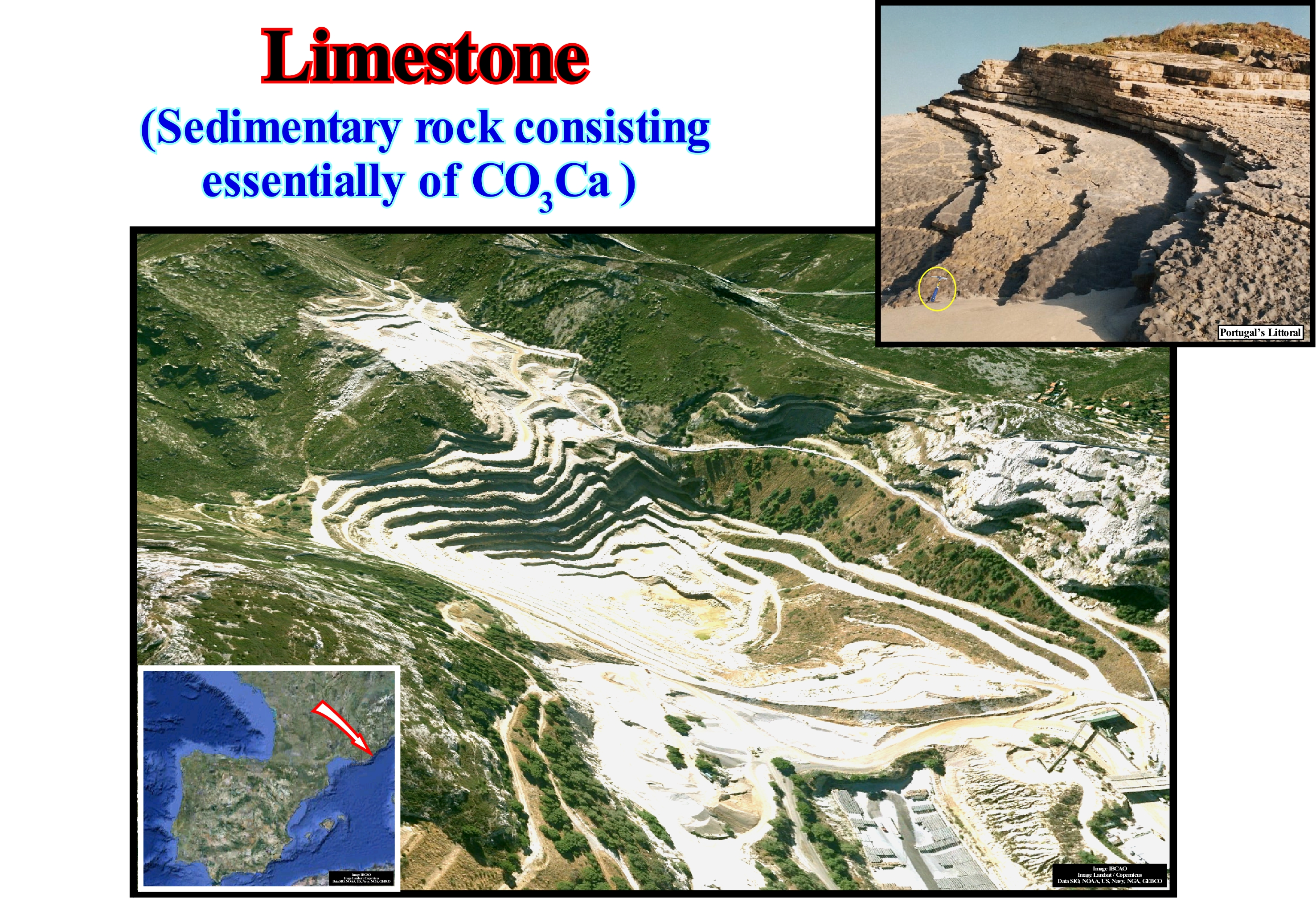
In general, the limestones, as we can see in this picture, are very compact rocks, well stratified and subjected to intense chemical erosion, because they are, essentially, composed of carbonate minerals. However, limestones may contain a certain amount of silica (in the form of chert, for example), clay, silt and sand, either in disseminations, nodules or thin intercalations. Marine organisms are the main source of calcite of the limestones. These organisms secrete shells that, after their death, settle on the sea floor in the form of mud or conglomerates in coral reefs. Calcite can, also, be deposited from super-saturated meteoric waters, as in stalagmites and stalactites. Calcite can be formed into oolites (oolitic limestone), which is recognizable by its granular appearance. Limestones, which make up about 10% of the total sedimentary rocks, can form in marine, lacustrine and evaporitic (salt) environments. As limestones are, partially, soluble in acid solutions, when they outcrop, they create erosion morphologies very varied. Although limestones are, widely, used in construction and sculpture (marbles, which result from the metamorphism of limestones), they are also used in the: (i) Manufacture of lime ; (ii) Manufacture of cement ; (iii) Conditioning agricultural land ; (iv) Paving roads ; (v) As reservoir rocks, in oil exploration ; (vi) Desulphurization ; (vii) Manufacture of glass ; (viii) Manufacture of paper, plastics and paints ; (ix) Toothpastes ; (x) To Avoidance of methane explosion (coal mines) ; (xi) Food as a source of calcium. In conclusion, it can be said that limestones are sedimentary rocks composed of calcite from evaporation lakes, seas and marine environments with seashells. Although limestone can be deposited in almost all the sedimentary processions that make up a sequence-cycle, they are, particularly, common in transgressive systems tracts, in association with relative sea level rises, in acceleration, during which the sedimentary basin has a significant continental shelf.
Limit of Backrush......................................................................................................................................Limite du courant de retrait
Limite de refluxo (espraiamento) / Límite de corriente de reflujo / Strombegrenzung für den Rückzug / 撤回的电流限制 / Мористая граница отката волны / Limite di corrente di ritiro /
Maximum extension of the backrush current from which a drift beach current may be present. The limit of the backrush current, which marks the spreading, is, more or less, the line of demarcation of the presence of waves on the beach.
See: « Surf Zone »
&
« Breaking »
&
« Outline of Breakers »
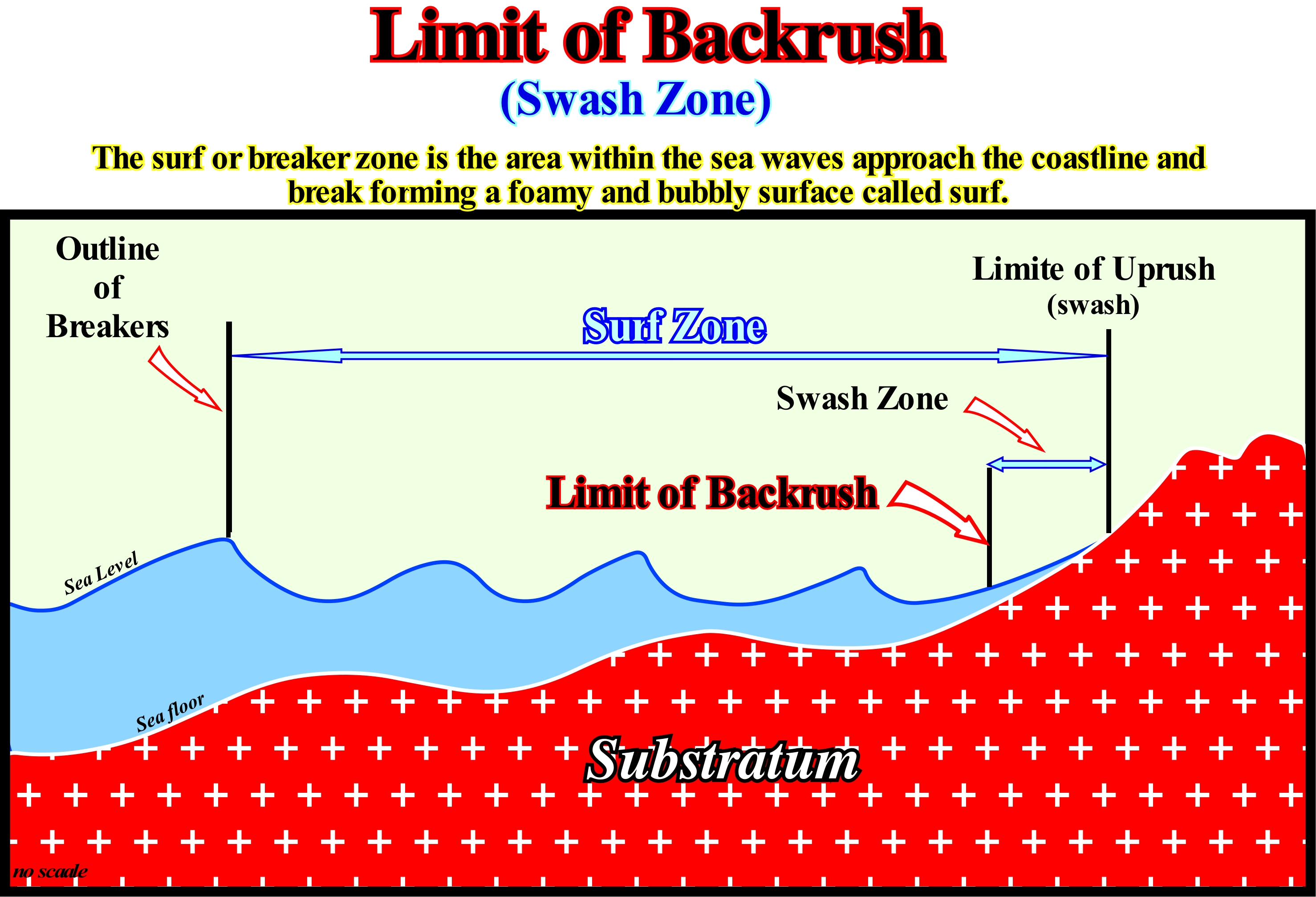
Since a sea-wave breaks near the shoreline, a current is formed, which rises upwards, perpendicularly, to the direction of the sea-wave (usually it is oblique to the coastline), which is called the uprush current. The uprush current when moving upstream loses energy, due to the slope and friction of the substratum (usually constituted, or better covered by a layer, more or less, thick of sand), and reverses the direction. This inversion creates a new current, called backrush or backwash current, which flows seaward along the slope of the substratum. The uprush and backrush currents not only move in opposite directions, but have different flow directions. The uprush current flows, perpendicularly, to the direction of the sea-waves (which is generally oblique to the coastline), while the backrush current flows along the slope (line of greatest inclination) of the substratum. It is only when the direction of the waves is parallel to the coastline that the swash currents (set of the uprush and backrush currents) have parallel flows. In this particular case, there is no formation of beach drifting* (foreshore drift), which, in general, limits downstream the backwash current. Do not confuse beach drifting, which is the realm of the uprush and backrush currents, with littoral current** (longshore drift, offshore drift), which limits downstream the surf zone (area where the waves approach the coastline until the height increase and constraint breaks them). Certain geoscientists consider the swash zone as synonymous with the intra-tidal zone. It may be said that the maximum extent of uprush current is the next wave, since a backrush current moves toward the trough of next wave cell. It is clear that a backrush current has nothing to do with undertow current (assuming this type of current exists), which, for some authors, is the current that moves along the sea floor and flows beyond the backrush current.
(*) Zigzag current with a longitudinal component that forms on the beaches in the surf zone hit by the swash currents (uprush and backrush), as a result of the accumulation of water (and sediments) by the currents of inflow and reflux when the surf is oblique to the coast.
(**) A water-body moving along the coast, outside the surf zone, coming from the accumulation of the backrush and beach drifting waters of, when the wave breaking is oblique to the coast. It has an important morphogenic action, due to its transport capacity.
Limit of Uprush..........................................................................................................................................................................Limite du jet de rive
Limite de irrupção (espraiamento) / Límite de irrupción (espraiamento) / Beschränken Vorfeld / 限制助跑 / Верхняя граница прибоя волны / Limite di uprush /
End of the strand, i.e., the point where the uprush current is inverted and becomes a backrush current, which flows seaward according to the line of greater slope of the sea floor.
See: « Surf Zone »
&
« Breaking »
&
« Limit of Backrush »

The sea-waves travel with a form, i.e., the water always stays, more or less, in the same place. To understand this, simply observe a tree trunk or other object floating on the sea. It moves a little towards the coast, when the crest of the wave passes and then turns backward when the trough between two waves passes. The tree trunk is, always, more or less, in the same place, as the water around it. When these oscillation waves (like the waves in open sea) approach the coast they become higher and higher and the crests sharpen (sea-breaks), until they break near the coast forming swash currents (translation waves). After breaking, in the surf zone, the waves, now less high, continue to move, breaking again near the coastline. Since a wave breaks, the water travels perpendicularly to the direction of the waves on the substrate towards the continent (uprush current), and then descends seaward following the slope substratum (backrush or backwash current). The uprush limit, as shown in this diagram, corresponds to the maximum extension line of the uprush current, being the swash zone, the area limited between the uprush limit (uprush current) and the maximum extension of then backrush current (limit of backrush). The uprush current can transport sand upright and gravel when the waves are high enough. The backrush current transports the sedimentary particles back downstream. The speed (v) at which the waves approach the coast can be determined by dividing the wave-length (L) by the period (T). For instance, when L is 24 m and T 8 seconds, the velocity is 3 m/s. The period of most of the waves within the surf zone varies between 2 and 20 seconds, and L between 6 and 600 m, which gives speeds between 3 and 30 m/s. At a depth of half of L, the orbital motion (movement of an object in an orbit around a fixed point) of the water particles of the oscillation waves disappears, as well as, the erosive action of the waves which, usually, does not exceed 50 m depth.
Limnetic Zone...................................................................................................................................................................................................Zone limnique
Zona límnica / Zona límnica / Limnischen Zone / 湖沼区 / Прибрежная часть озера / Zona Limnetic /
A well-lit, shallow area of a lake, far from the shore, occupied by a wide variety of phyto-plankton (algae and cyanobacteria), as well as zoo-plankton, small crustaceans and fish.
See: « Photic Zone »
&
« Photosynthesis »
&
« Cyanobacteria »

In lacustrine ecosystems, there are three main habitat zones: (1) Surface Zone ; (2) Limnetic zone and (3) Deep zone. The surface zone is the shallow-water zone, with light penetrating to the bottom of the water and supporting rooted plants and animals living in the background. In the he limnetic zone, the water allows an effective penetration of light, which supports plant and animal plankton. The deep zone is the bottom area and deep-water in addition to light penetration, which supports organisms bodies adapted to darkness. Thus, as illustrated in this figure the limnetic zone can be defined as the illuminated surface waters, in the area where the bottom of a lake is too deep to support rooted aquatic plants. This area is occupied by a variety of phyto-plankton, consisting mainly of algae and cyanobacteria, as well as, zoo-plankton formed by small crustaceans and fish. In a lake, most photosynthesis occurs in the limnetic zone. The limnetic zone is, actually, free surface water that is surrounded by the surface zone. As it is well lit, it is propitious to plankton, whether it be phyto-plankton or zoo-plankton. This is important, since without the aquatic plankton, there would be few organisms that could survive and, certainly, no human being. In fact, a wide variety of fish and fresh-water plants also occupy this area. Do not forget that in lakes and ponds, the temperature changes in a seasonal way. During the summer, the temperature can range from 4° C at the bottom to 22° C at the top. During winter, the temperature at the bottom may be 4 ° C, while at the top it is 0° C (ice). Between the two layers, there is a narrow strip called the thermocline where the water temperature changes rapidly. During spring and fall, there is a mixture of the upper and lower layers due to the winds, which results that the temperature is, more or less, uniform and around 4 ° C. This mixture circulates the oxygen throughout the water-body. In lakes and ponds that do not freeze during the winter, it is evident that the upper limnetic layer is slightly warmer.
Limnology.............................................................................................................................................................................................................................Limnologie
Limnologia / Limnología / Limnologie / 湖沼學 / Лимноло́гия / Limnologia /
Part of the hydrology that studies continental waterbodies (stagnant or flowing), sweet or salty, especially, lakes, ponds and rivers (natural or not) including their biological, physical, chemical, geological and hydrological aspects.
See: « River »
&
« Lake »
&
« Hydrology »
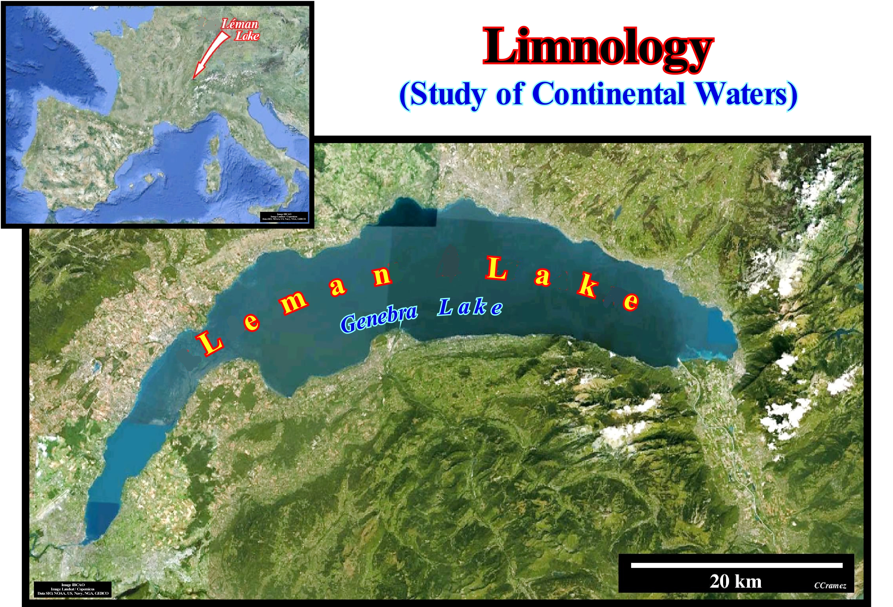
The term limnology was first used by the Austrian François-Alphonso Forel (1841-1912), when he studied Lake Geneva, in Switzerland, and considered it as the oceanography of lakes. Although today (post-glaciation), a large majority of lakes are of glacial origin, such as Lake Geneva (Switzerland) illustrated in this figure, during the geological history there existed a large number of lakes of tectonic origin. These lakes formed in association with the lengthening of the continental crust, which caused the break-up of the supercontinents, that is, in association the rift-type basins. In this type of sedimentary basins, every time, that the enlargement (differential subsidence) is not compensated by a sedimentary charge, necessarily, it forms a water column, i.e., a lake, that over time is filled by lacustrine sediments. It can be said that whenever the internal configuration of a rift-type basin is parallel or sub-parallel, subsidence was not compensated for by the sedimentary charge and a lake is formed. The term compensated means that the lengthening rate (creation of available space for the sediments) is equal to the filling rate and thus all available space is filled. One of the most important aspects of limnology is the study of water eutrophisation*, which contributes significantly to the formation of sediments rich in organic matter, that is to say, of potential source-rocks, such as, for instance, in rift-ype basins. Recall that eutrophication** is the response to excessive enrichment of water in nutrients, especially phosphorus and nitrogen. Eutrophication can be natural or artificial. Anthropogenic eutrophication, in the absence of control measures, is done at a much faster rate than natural eutrophication. The increased fertility of the lakes causes an excessive development of algae and aquatic plants and a de-oxygenation, which allows the preservation of the dead organic matter in the bottom of the lake and, later, the formation of potential source-rocks.
(*) Process by which nutrients accumulate in an environment or habitat (terrestrial or aquatic).
(**) There is eutrophication or hyper-trophication when a water-body becomes excessively enriched with minerals and nutrients which induce an excessive growth of plants and algae.
Line of Propagation (sea-waves)......................................................................................................................Orthogonale (De l'onde)
Ortogonal (ondas) / Ortogonal (de onda) / Orthogonal Welle / 正交波 / Линия распространения / Linea di propagazione /
Line perpendicular to the crest of the wave at a given point. The set of orthogonals of a wave system is the wave plane. When determining a wave plane, it is necessary to take into account the layout of the isobaths due to the deformations that the sea floor induce in the direction of the waves causing them to converge in bays and to diverge in the ground tips and capes.
See: « Isobath »
&
« Crest (wave) »
&
« Wave »

It is important to remember here some theoretical notions about waves, in particular, what characterizes a propagating vibration. A vibration of a particle of water, for example, is characterized by its amplitude, i.e., by the amplitude of its displacement and by the time it takes to return to its initial position (vibration period) or by its inverse, i.e., by the number of back and forth that occurred during one second (frequency). In most environments, amplitude does not depend on frequency and conversely. When, rarely, amplitude depends on frequency, the environment is said to be dispersive. The swell is a dispersive wave. A wave being a moving vibration, it is necessary to take into account the speed of propagation and the initial conditions, i.e., if it starts at its maximum, minimum or intermediate position (this is called the phase). The distance it travels during a single vibration is called the wave-length, but the wave propagation length should be more correctly stated. When we speak of vibrations along a string, we are talking about vibrations in one direction (1D), but when we hit the skin of a bass drum or when we lay a rock on a lake we observe circular ridges that move away from the point of impact, that is, we create 2D waves. Finally, when in a soccer game, the referee whistles, all spectators, whether they are on top or bottom, near or far, hear the sound of the whistle. Sound is a vibration that propagates in space, and in this case the wave has the form of a sphere that expands to propagate (vibration in 3D, three dimensions). The waves represented in this figure are two dimensions (2D), such as those formed when we hit a bass drum or when we drop a rock in a lake. The crests of the two intersecting wave systems are very visible as well as the respective orthogonal ones.
Linnaean System.............................................................................................................................................................Linné (Système de classification)
Linéus (sistema de classificação) / Linéus (sistema de classificación )/ Taxonomy, Linnaean System / 分类学, 林奈系统 / Система Линнея / Tassonomia, Sistema di Linneo /
System of classification of living beings in a hierarchy, whose most familiar ranks are genera and species.
See: « Animalia (kingdom) »
&
« Paleontology »
&
« Life »
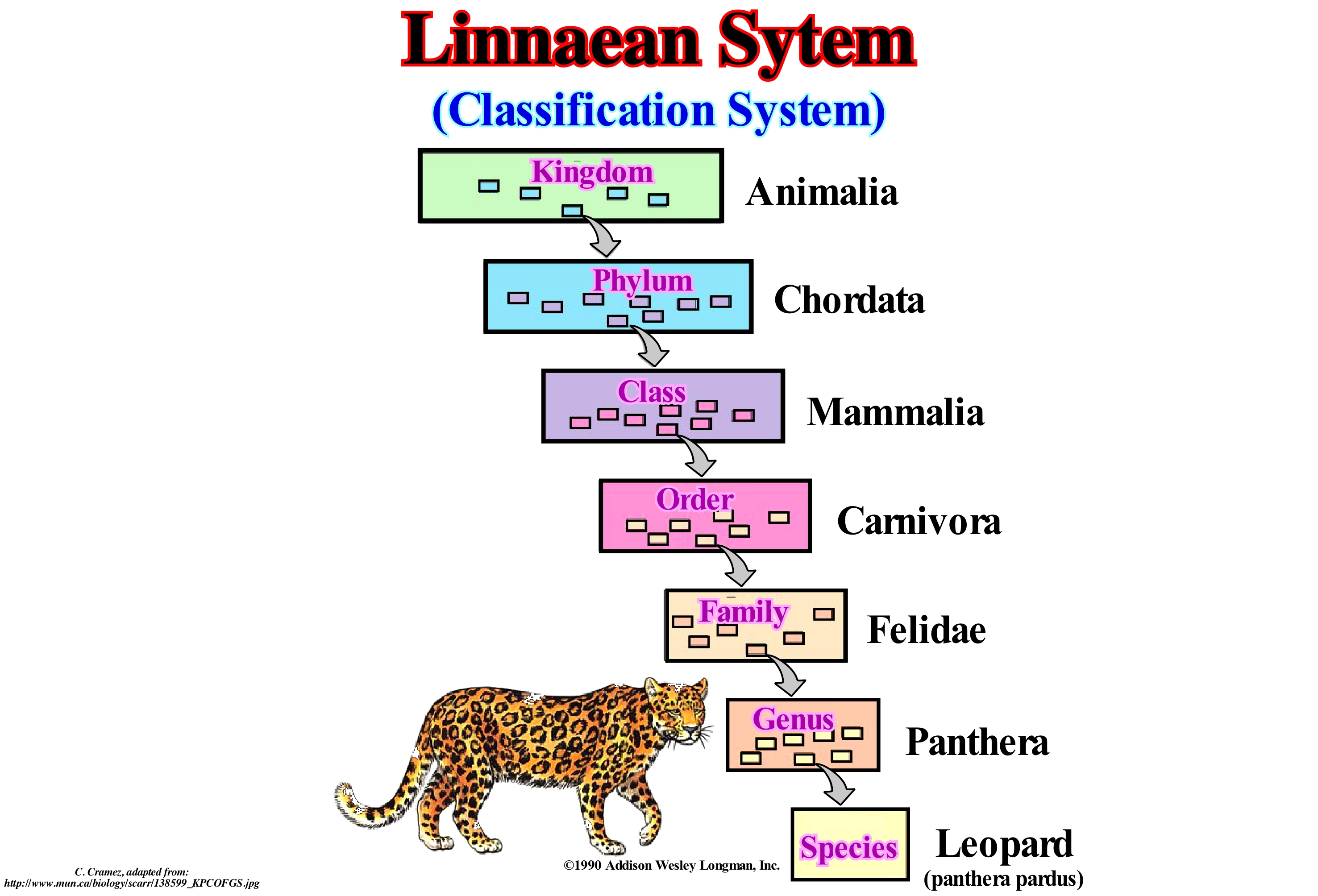
This classification system was developed by Carolus Linnaeus (commonly known as Carl von Linné) in the 18th century during the great expansion of natural history. As illustrated in this figure, Linnaeus taxonomy classifies living things in a hierarchy, beginning with the Kingdoms. Kingdoms are divided into Phylums. Phylums are divided into Classes, and then into Orders, Families, Genera, and Species and, within each of these divisions there are subdivisions. Groups of organisms in any of these classifications are called taxa (singular, taxon) or phyla or taxonomic groups. When a scientist classifies a new insect, it seeks to classify it into an existing category, based on an established logic, and verifies which family it belongs to and finds, eventually, the most appropriate name for that species. One quality of the Linnaeus Taxonomy is that it can be used to develop a simple and practical system for organizing different types of living organisms. The most important aspect is the general use of bi-nominal nomenclature, the combination of a generic name and a specific name (e.g., syriacus), to identify the species. Thus, for instance, the Syrian hibiscus* (Syrian rose, rose-of-sarom or mime) is, uniquely, identified by the name Hibiscus syriacus (Kingdom: Plants ; Phylum: Magnoliophyta ; Class: Magnololiophyta ; Order: Malvales ; Family: Malvaceae ; Genus: Hibiscus ; Species: Hibiscus syrianis). No other plant species can have this binomial. In this way, all species can be given a single and stable name. The nomenclature rules for all types of living organisms under the Linnaeus taxonomic system were adopted by a large majority by professional biologists. The rules governing the nomenclature and classification of plants and fungi are contained in the International Code of Botanical Nomenclature maintained by the International Association for the Taxonomy of Plants. Similar codes exist for animals and bacteria. Scientists follow these codes so that the names of organisms can be as clear and stable as possible. (http://en.wikipedia.org/ wiki/ Taxonomia_de_Lineu).
(*) Woody bush with many fibres, which can reach 3 meters high, origination from China and characterized by the strong aroma exhaled during the warm nights, which South Korea adopted as national flower.
Liquid Natural Gas (Gas condensate).........................................................,....................................................Gaz naturel liquide
Gás natural líquido / Gas natural líquido / Flüssigerdgas / 液化天然气 / Сжиженный природный газ / Gas naturale liquefatto /
Liquid hydrocarbons dissolved in the saturated natural gas and leaving the solution when the pressure is below the dew point*. Mixture of low density liquid hydrocarbons present as gaseous components in many natural gas fields. This mixture condenses when the temperature is reduced below the temperature and pressure of the dew point of the gas. Condensed gases are also called, simply, condensate, or even sometimes gasoline because they contain hydrocarbons within the gasoline boiling range.
See: « Methane »
&
« Conventional Gas »
&
« Petroleum »

Condensates or liquid natural gases are gaseous hydrocarbons, which are, often, found in certain reservoir-rocks and which condense to form liquid hydrocarbons at atmospheric conditions. In general, condensates have a low density and a high grade API (America Petroleum Institute). If the API degree is greater than 10, the condensate floats on the water. As shown in this pressure/temperature diagram, the presence of a condensate, as a liquid phase, depends on the rock-reservoir, temperature and pressure conditions, which allow the condensation of a liquid to vapour. The production of condensates can be complicated by the pressure sensitivity for certain condensates (reaction of minerals with the fluid, which is a function of the structure of the reservoir and the distribution of minerals). Thus, during production, there is always a risk that the condensate will change from gas to liquid if the reservoir pressure drops below the saturation point ("dew point pressure" is the pressure at which the first liquid condensate turns into gas). If the production of gas is preferable to the production of liquids, the pressure of the reservoir can be maintained by injecting fluids. The gas produced in association with a condensate is called wet gas**. The API degree of a typical condensate ranges from 50° to 120°. As illustrated in the above sketch, all this means, that function of temperature and pressure, a single unitary system can behave as a gas, liquid, solid or as a mixture of the three. A condensate is, primarily, composed of propane, butane, pentane and heavier hydrocarbon fractions. A condensate does not form just in a reservoir-rock, it can be formed in an oil pipeline and in surface installations.
(*) Temperature to which air must be cooled to become saturated with water-vapour.
(**) The term "wet gas" has been used to describe a range of conditions varying from a humid gas which is gas saturated with liquid vapour to a multiphase flow with a 90% volume of gas. (https://en.wikipedia.org/wiki/Wet_gas)
Liquified Flow...........................................................................................................................................................................................................Flux liquifié
Fluxo ou escoamento liquidificado / Flujo licuado / Verflüssigte Strömung / 液化流 / Сжиженный поток / Flusso liquefatto /
When the dispersion of the materials and the maintenance of these in suspension is promoted by the collision between the particles.
See: « Turbiitic Current »
Listric Fault.............................................................................................................................................................................................................Faille listrique
Falha lístrica/ Falla lístrica / Listric Fehler / Listric 故障 / Листрический разлом / Fagglie listrica /
Fault, which at the top, is normal and reverse at the bottom. As the plane plane of a listric fault is curved, many geoscientists, in the wrong way, call all faults that have a flat curved fault plane as listric fault. All listric faults have a curved plane, but not all faults with a curved fault plane are litstric.
See: « Footwall »
&
« Fault »
&
« Transform Fault »
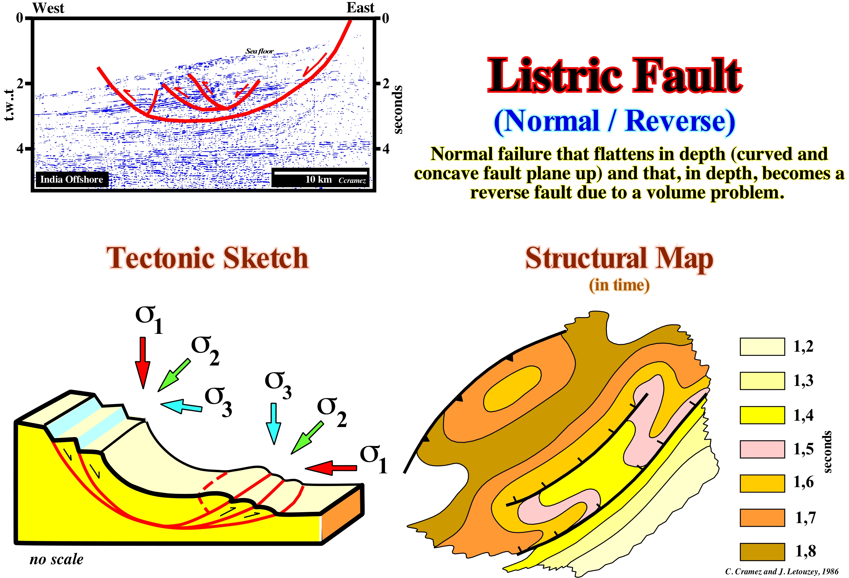
These sketches illustrate the characteristics of a listric fault. The upper part corresponds to a normal fault. The σ1 (the main axis of the effective stresses ellipsoid) is vertical and the σ2 is horizontal and oriented N-S. The σ1, σ2 and σ3 axes are the main axes of the effective stresses ellipsoid, which result from the combined action of the lithostatic pressure (sedimentary column weight), hydrostatic pressure (water column weight) and tectonic vector. In this example, the sediments are lengthened by normal faults that have an N-S oriented fault plane (fault planes of both normal and inverse faults are always parallel to σ2). The lengthening of the sediments in the upper part induces, at the lower part, a local compressional tectonic regime (σ1 horizontal) that shortens the sediments by inverse faults. The lengthening of the upper part is compensated by the shortening of the lower part. This type of fault is characteristic of surface landslides, since it requires relatively small confining pressure. Under a certain sedimentary column, the listric fault are absent. On the contrary, they are very frequent in the upper levels of the continental slope, where the σ3 is, in general, vertical. The fault plane of a listric fault is curved and continuous. Sometimes geoscientists in charge of the tentative geological interpretations of seismic lines tend to consider two faults, a normal fault above and a reverse fault below, which is, totally, wrong, since the plane a fault is continuous. Although the apparent movement of the faulted blocks is different in the upper and lower part. The same is, often, true in reactivated faults, that is, when, for instance, a normal fault formed during the Cretaceous is later, in the Miocene, it is reactivated as reverse fault. If the inversion is not complete, the fault is reverse (from Miocene), but it has a normal fault geometry at the bottom and a reverse fault geometry at the top.
Lithification...................................................................................................................................................................................................................Lithification
Litificação / Litificación / Lithification (Transformation eines Sediments im Festgestein) / Lithification (在综合岩石沉积物的转变) / Окаменение / Lithification (trasformazione di un sedimento in roccia consolidata) /
Conversion of sedimentary particles (loose) into solid rock masses. The process by which the sediments are compacted under the action of pressure, expelling the liquids that saturate the porosity, and which, gradually, becomes an endogenous (sedimentary) solid rock, in which the porosity is partially destroyed by compaction and cementation.
See: « Sedimentation »
&
« Compaction »
&
« Diagenesis »

A sediment whether it is deuterogene (of secondary origin, i.e., clastic or detrital) or proterogene (primary origin, i.e., formed by precipitation) is not a sedimentary rock (endogenous by exogenous contrast) before the grains clump together each other. The material that adheres the grains to one another and which is called cement, is most often a proterogene sediment (mineral that forms when water passes through the free spaces between the sediments). If water (sea-water or underground) contains the necessary chemical elements, crystals form between the grains that adhere to each other. Calcite, quartz, and sometimes hematite form, often, the cement of sedimentary rocks. The photographs, illustrated in this figure, underline the difference between a pile of sedimentary particles (left photograph), and a sedimentary rock made up of the same particles (right photograph). The passage from one to the other is the lithification. A pile of sedimentary particles (clasts), as in the photograph on the left, becomes more rapidly a sedimentary rock, the more buried it is, as geostatic pressure compresses the grains against each other. The process of transformation, that is, lithification can last hundreds of thousands of years. Certain proterogene sedimentary particles are lithified by recrystallization of the minerals that constitute them, rather than by cementation. The typical example is the formation of many limestones and shales, which require a recrystallization of the sedimentary grains at the site. In this process, the minerals recrystallize in response to a change in the chemical environment (an increase in pH), because certain minerals are more stable than others under certain conditions. When the mineral grains recrystallize (whole grains or only the edges of the old ones), they grow together and create new boundaries between the grains, turning the sedimentary particles into a compact rock.
Lithodeme...............................................................................................................................................................................................................................Lithodème
Litodema / Litodema / Lithodeme (geographische Begriff mit einem beschreibenden Begriff lithischen) / Lithodeme(地理与岩屑描述长期长期) / Литодема / Lithodeme (termine geografico con un termine descrittivo litico) /
Term used to express the lithology and conditions of deposit of a rock independent of age and geological context. Certain geoscientists use the term lithodeme to combine a geographical location with a lithology (e.g., "La Luna limestones") . Sometimes synonymous with Formation (geological).
See: « Facies »
&
« Formation (geological) »
&
« Lithostratigraphic Unit »

The rocks of this outcrop constitute the Zumaya lithodeme (a small village on the coast of Guipúzcoa, about 35 km from Donosti - Saint Sébastian and 75 km from Bilbao, Spain). The lithology corresponds to an alternation of sandstones (fining upward) and shales deposited in a deep-water depositional environment. The term lithodeme (more or less, synonymous with a geological formation), which is the basic unit of lithostratigraphy (a set of rocks or minerals that has its own characteristics, in relation to its composition, age, origin or other similar properties), is replaced, often, by the term litho-environment. In modern terms (sequential stratigraphy), this lithodeme corresponds to a stacking of submarine basin floor fans deposited in association with a significant relative sea level fall, which put the sea level lower than the basin edge. Such a fall of the relative sea level* has changed the geological conditions of the basin from highstand to lowstand, i.e., with exhumation of the continental platform, which implies a basinward and downward displacement of the shoreline and depositional coastal break, which are, on seismic data, more or less, coincident due to the seismic resolution. Within a sequence-cycle during the regressive episodes (lowstand prograding wedge and highstand prograding wedge) the shoreline moves seaward and upward, which means that there is aggradation (upbuilding) and progradation (outbuilding), but that the progradation is largely superior. At first, however, EPR scientists (Exxon's "Exploration Production Research") considered that the progradation of the shoreline, necessarily, implies aggradation, i.e., the shoreline is displaced seaward and upward. This seaward displacement destroys the provisional equilibrium profile of water-courses, which forced them to incise their beds to find a new provisional equilibrium profile. Such excavation, greatly, increased the terrigeneous influx and the charge of the rivers. As the rivers flow on the continental slope, the sedimentary particles are carried along the continental slope by turbidity currents that decelerate beyond the lower continental slope break. Since the turbidite currents began to decelerate, in general, in the abyssal plain, they lost competence and deposit the sedimentary particles in the form of submarine basin floor fans. The deposition time of each submarine lobe (usually a sandstone layer) is, geologically, instantaneous (tens of minutes), while the thin layers of pelagic clay deposited after each turbidite lobe took, probably, thousands of years to deposit. It is these pelagic layers that allow to date the turbiditic layers, since all the fauna and flora found in the turbidite layers are transported not only from different environments but also from rocks of different ages. As the submarine basin floor fans (SBFF) emphasize the minimum hiatus with the preceding sequence-cycle, the age of the pelagic shales allows to date, with a reasonable precision, the age of the unconformity limiting the two stratigraphic-cycles, i.e., they allows to date the relative sea level*** fall that induced the unconformity, as well as, its correlative deep-water paraconformity. Later, during the Miocene, the submarine basin floor fans of this area (Zumaya) were deformed and uplifted, at the time of the mountain belt formation (more or less 10 Ma), taking the aspect illustrated in this photograph.
(*) If the relative sea level falls, but not enough to bring the sea level lower than the basin edge (at the level of a sequence-cycle) the associated erosional surface is too small to create an unconformity. It was in this sense that Exxon's geoscientists, at the beginning of the sequential stratigraphy, considered Type I Unconformity (exhumation of the entire continental shelf or relative uplift the coastal plain and continental platform) and Type II Unconformity (partial exhumation of the continental shelf or small uplift of coastal plain and shelf). At present time, geoscientists do not consider Type II Unconformities anymore. They prefer to consider Descending Sedimentary Systems Tracts or Forced Regressions.
(**) Exxon was the brand name of Exxon Corporation for oil and natural resources. However, before 1972, it was known as the Standard Oil Company of New Jersey. In 1999, Exxon Corporation merged with Mobil to form ExxonMobil. The Exxon brand is still used by ExxonMobil's downstream operations as a brand name for some of its gas stations, engines and related products (the largest concentration of which are located in New Jersey, Pennsylvania, Texas and the Mid-Atlantic states and Southeast). Standard Oil Company of New Jersey was one of the seven sisters who dominated the global oil industry from the mid-1940s to the 1970s.
(***) Local sea level, referenced to the base of the sediments (top of the continental crust) or to the sea floor base. The relative sea level is the result of the combined action of tectonics (subsidence or uplift of the sea floor) and the absolute (eustatic) sea level, which is referenced to the Earth's centre by tide-gauge measures or by NOAA (National Oceanic and Atmospheric Administration) measures using satellite altimetry. The satellite data, must be calibrated by corrected tide-gauge results, that is to say, measures taking into account the subsiding and uplifting site areas.
Lithofagy................................................................................................................................................................................................................................Lithophagie
LitofagiaLithophagie / Litofagia / Lithophagie / Lithophagy (摄取的石头来帮助消化的做法) / Литофагия / Litofagia (la pratica di l'ingestione di pietre per aiutare la digestione) /
Intake of stones to aid digestion. Examples of lithosphagy are found in many birds and crocodiles.
See: « Arenite »
&
« Erosion »
&
« Glossifungite »
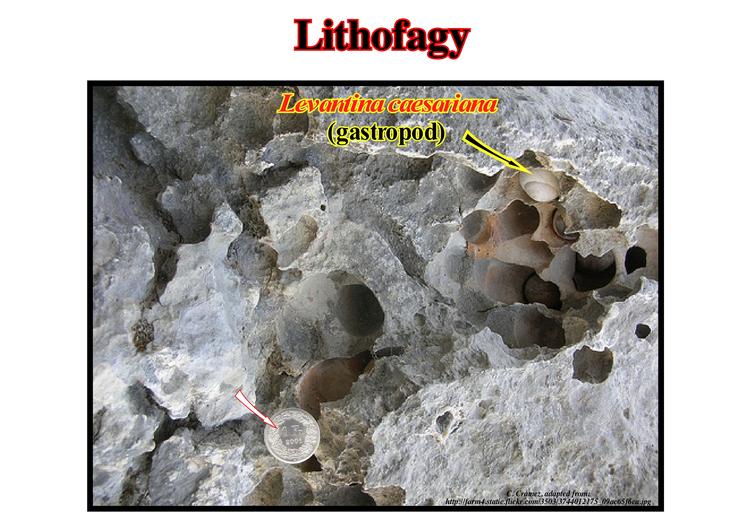
Lithophagy or geophagous is the ingestion of mineral substances, not only from the soil, but also from sand, gravel, and rocks. The term lithophagy includes both intentional, but also accidental intake. Geophagous or lithophagy is a surprising, widespread and normal behaviour that is documented in vertebrates, from rodents to whales, to turtles and birds. As human presence expands into hitherto inhabited areas only by wild animals, the presence of chemicals in the soil is becoming frequent and widespread, which is, extremely, dangerous for lithophagous animals. Certain organic chemicals have a strong tendency to be distributed to soil, such as pesticides and other anthropogenic organic compounds. Lithophagy may supplement poor diet and promote pharmacological treatments. In fact, the ingestion of stones by lizards and crocodiles can help maceration of prey, a function similar to that of the grain ingested by birds. As lizards and crocodiles are without gizzards, this concept of assisted maceration can still be reviewed. The hypothesis that lithophagy in crocodiles is to provide a ballast is not corroborated. Lithophagy is, also, practiced by Adelia penguins (Pygoscelis adeliae), several pinipeds, and some prehistoric lizards. Once they regurgitate the rocks, on land, these rocks in the animals that breathe air can, in fact, be ingested as ballast. The ingestion of sand and gravel by turtles could serve to facilitate maceration in the same manner as lithophagy by lizards and crocodiles, although turtle feeding is composed mainly of vegetables. Tortoises in captivity (Terrepene ornate) and others (Tsunamis recrudescence, Occipital antiquate, Gophers Agassiz, Hermann Testes) intentionally ingest dark soils without sand that passes through the digestive system completely. Any cellulosic micro-organism from a soil can help the cellulose digestion of the vegetative components of the diet and may be the main reason for such behaviour (Hui, C.A.- 2004).
Lithosome................................................................................................................................................................................................................................Lithosome
Litossoma / Litosoma / Lithosome / Lithosome (通过与不同岩性围岩岩侵入) / Литосома / Litosoma /
Litostratigraphic body or litostratigraphic unit with a vertical and lateral boundary, more or less, isolated, but which is interconnected with one or more sedimentary bodies of different composition. A lithosome is a rocky mass of character, essentially, uniform with respect to the adjacent masses of different lithology. Ex: Shale lithosome, limestone lithosome, etc.
See: « Facies »
&
« Systems Tract »
&
« Lithostratigraphic Unit »
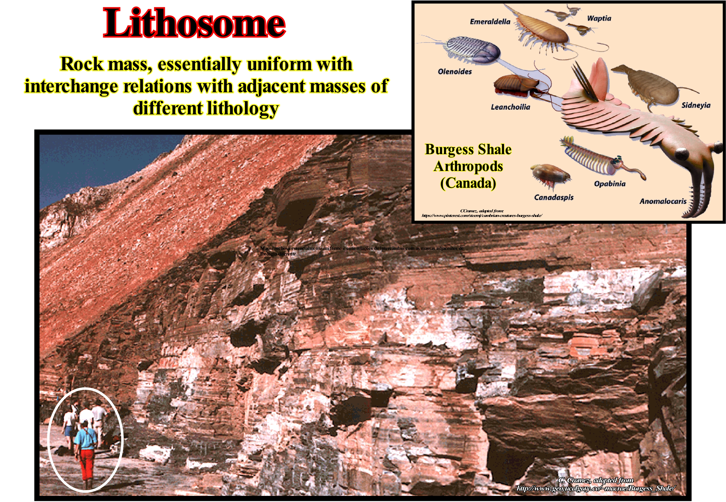
Currently, one of the most well-known lithosomes in the world is the lithosome of the Cathedral Shales (Middle Cambrian) of the Stephen formation, in the Burgess Pass region, between the mountains of Wapta and Field (Rocky Mountains). These rocks formed at about 530 Ma. In them there is a great variety of marine fossils, vastly, superior to the one that is in the present seas. At the time-deposition, it appears that the region of Burgess Pass, which was near the equator, was a the divergent continental margin of North America. On the other hand, it appears that the more or less carbonated shales were deposited under anoxic conditions (low oxygen content), at the base of a significant escarpment, in association with significant submarine failures (slumps). The absence of bioturbation (the process of constructing sedimentary structures of biological origin characteristic of specific environments, disturbing the sedimentary or pedogenic structure to which they overlap) and the presence of a large amount of pyrite do not falsify, but rather corroborate an environment of deep-water deposition, which implies that all organisms were transported to the base of the cliff by small debris streams that have escaped from the edge of the cliff. This hypothesis explains in a satisfactory way the very different orientation of the fossils and their extraordinary preservation. Up to 1994, 125 genera have been described in these shales. Among the main fossils that can be found there are, among others: (i) Anomalocaris or anomalous shrimp, which is an extinct proto-arthropod ; (ii) Marrella splendens, which is a small trilobite-like arthropod ; (iii) Olenoides serratus, which is a trilobite ; (iv) Vauxia gracilenta, which is a sponge (the simple or sessile organism, which may be fresh or salt water, is fed by filtration, pumping water through the walls of the body by holding the food particles in its cells) ; (v) Tuzoia, which is a crustacean bivalve similar to certain shrimps living in modern pickles ; (vi) Ottoia, who was a carnivorous priapulid, probably, living in pits like modern priapulidae ; (vii) Leanchoila, which is a spider-shaped arthropod, etc., etc. In this figure are illustrated several arthropods reconstituted from fossils found were found in the Cathedral shales: (a) Emerald, small, predatory arthropod with a long tail and antennae; (b) Wapiti, had a shell bivalve and superficially resembling a Perspicaris, but must have occupied a different place in the food chain, since the poor composition of its jaw suggests that it probably spent most of the time in the bottom from the sea in search of food ; (c) Olenoids, followed the basic structure of all trilobites - a cephalon, a thorax with seven articulated parts and a semicircular pigment, with long antennae and curved back along its sides ; (d) Leanchoilla, about 5 centimeters in length and long, whip-like probes mounted on front arm appendages ; (e) Sidneyia, with a length between 51 to 127 mm is one of the largest arthropods found in-the Cathedral shales. It is thought to have been a benthic carnivore that walked along the seabed in search of hard shell prey ; (f) Canadaspis had claws at the end of its frontal appendages that could have been used to stir the sediment, or to scrape the top layer which may have been a nutritious layer of microbes ; (g) Modest size Opabinia had a soft, segmented body with lobes along the sides and a fan-shaped tail (the head had five eyes, a mouth under the head and turned back, and a proboscis that probably passed food to the mouth), probably lived on the seabed, using the proboscis to look for small, soft foods ; (h) Anomalocaris, had a large head, a single pair of large, stalk-like eyes comprising approximately 16,000 lenses and a disc-shaped mouth. Stephen Jay Gould in his book "Wonderful Life", published in 1989, contributed to the dissemination of Burgess shale fossils. Gould suggested the extraordinary diversity of fossils indicates that life forms at the time were much more different in body shape than those surviving today, and that many of the original lineages were evolutionary experiences that became extinct. Gould's interpretation of the diversity of the Cambrian fauna was strongly based on the reinterpretation of the original publications of Charles Walcott Simon and Conway Morris. However, Conway Morris strongly disagreed with Gould's conclusions, arguing that almost all the Cambrian fauna can be classified in modern phyla.
Lithosphere....................................................................................................................................................................................................................Lithosphère
Litosfera / Litosfera / Lithosphäre / 岩石圈 / Литосфера / Litosfera /
Set of the crust (continental and oceanic) and upper mantle, which forms a rigid layer of the Earth's outer surface overlying the asthenosphere, which is more elastic (admits extension without breaking) of the Earth's mantle.
See: « Asthenosphere »
&
« Crust »
&
« Sial »
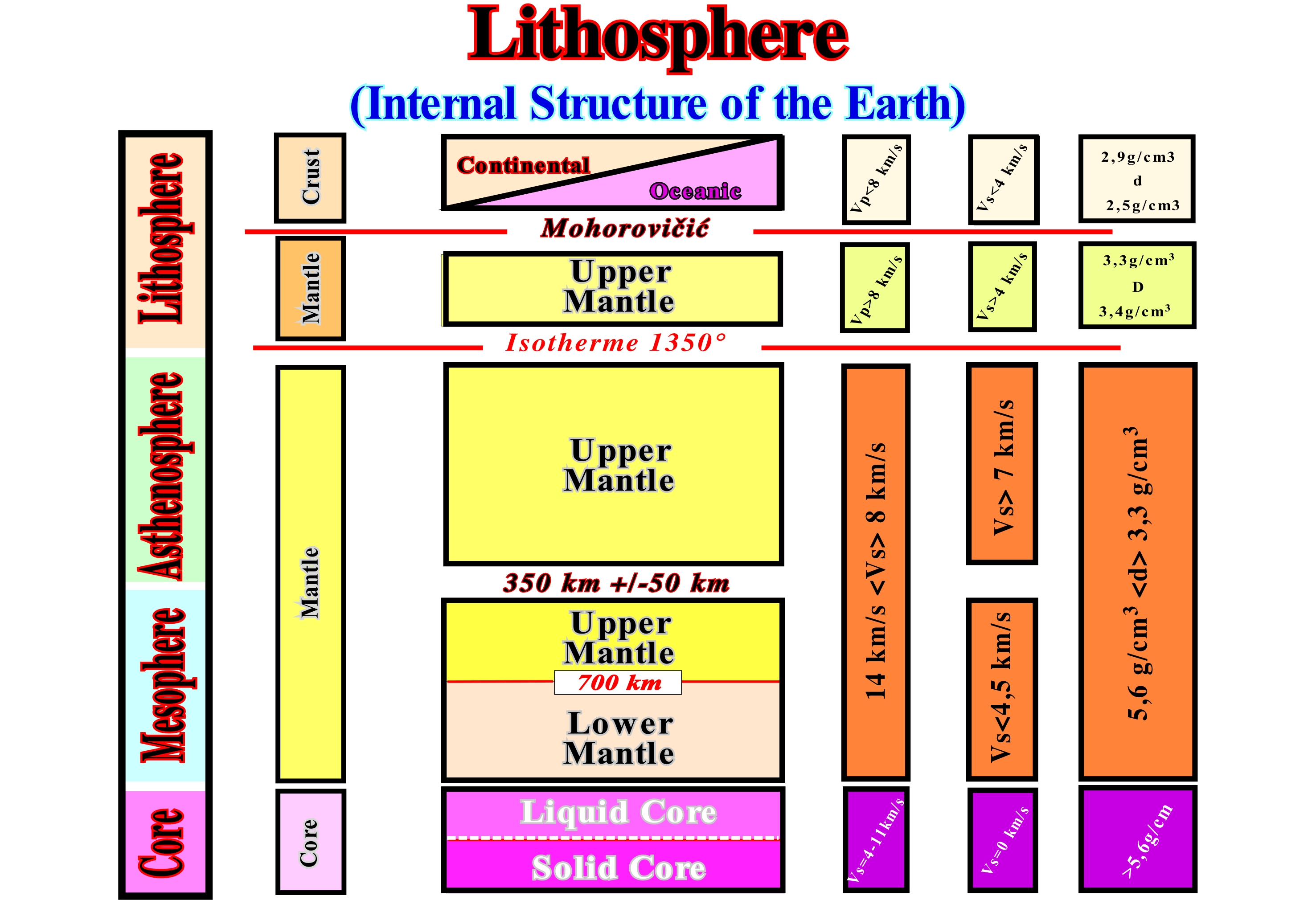
As can be seen in this diagram, the Earth's internal structure can be described from the petrographic and rheological (the way matter flows or deforms) point of view. From a petrographic point of view, the Earth can be divided into three more or less concentric envelopes: (i) Crust ; (ii) Mantle and (iii) Core. The crust can be continental or oceanic. The continental crust consists of exogenous rocks (granite and metamorphic rocks) covered by a film of endogenous sedimentary rocks, whose thickness varies between 30 and 70 km. The density of the continental crust ranges between 2.5 and 2.7 g/cm3. The bottom of the continental crust is, mainly, composed of gabbros. It has a density of about 2.8 g/cm3. The oceanic crust is composed of basaltic rocks and gabbros covered with hemipelagic and pelagic sediments. It has a density around 2.9 g/cm3 and a thickness ranges from 4 to 10 km. The mantle, which is composed of anhydrous peridotites and eclogites, has an average density of 3.3-3.4 g/cm3 and 3.3-5.6 g/cm3 in the lower part. The upper boundary of the mantle is underlined by the Mohorovičić discontinuity (4-70 km). The lower boundary is about 2,900 km deep and it corresponds to a phase change. The core Nucleus, which is composed mainly of iron and nickel, can be divided into a solid internal core and a liquid external core. From a rheological point of view, the Earth is divided into four large zones: (a) Lithosphere ; (b) Asthenosphere ; Mesosphere and (d) Core. The lithosphere, which is the rigid outer layer, has a thickness between 80 and 150 km. Its lower limit corresponds, roughly, to the low-velocity zone of the seismic waves (vp and SVG). The asthenosphere, which is a less rigid layer than the lithosphere, can deformed by flowage. The lower limit of the asthenosphere is poorly marked, but does not appear to exceed 350 km deep. The mesosphere corresponds to the set of the upper and lower mantle, whose base is about 2,900 km deep. The core, which is bounded between about 2,900 km depth and the Earth’s centre (± 6,370 km of depth). The outer part of the core is liquid and the inner part is solid.
Lithostratigraphic Unit..................................................................................................................Unité lithostratigraphique
Unidade Litostratigráfica / Unidad litostratigráfica / Lithostratigraphische Einheit / 岩石地层单位 / Литостратиграфическая единица / Unità litostratigrafica /
Set of rocks or strata characterized by a certain facies (lithology). A combination of lithological types or a set of rocks which has in common another determining lithological characteristic.
See: « Stratigraphy »
&
« Chronostratigraphic Unit »
&
« Biostratigraphic Unit »
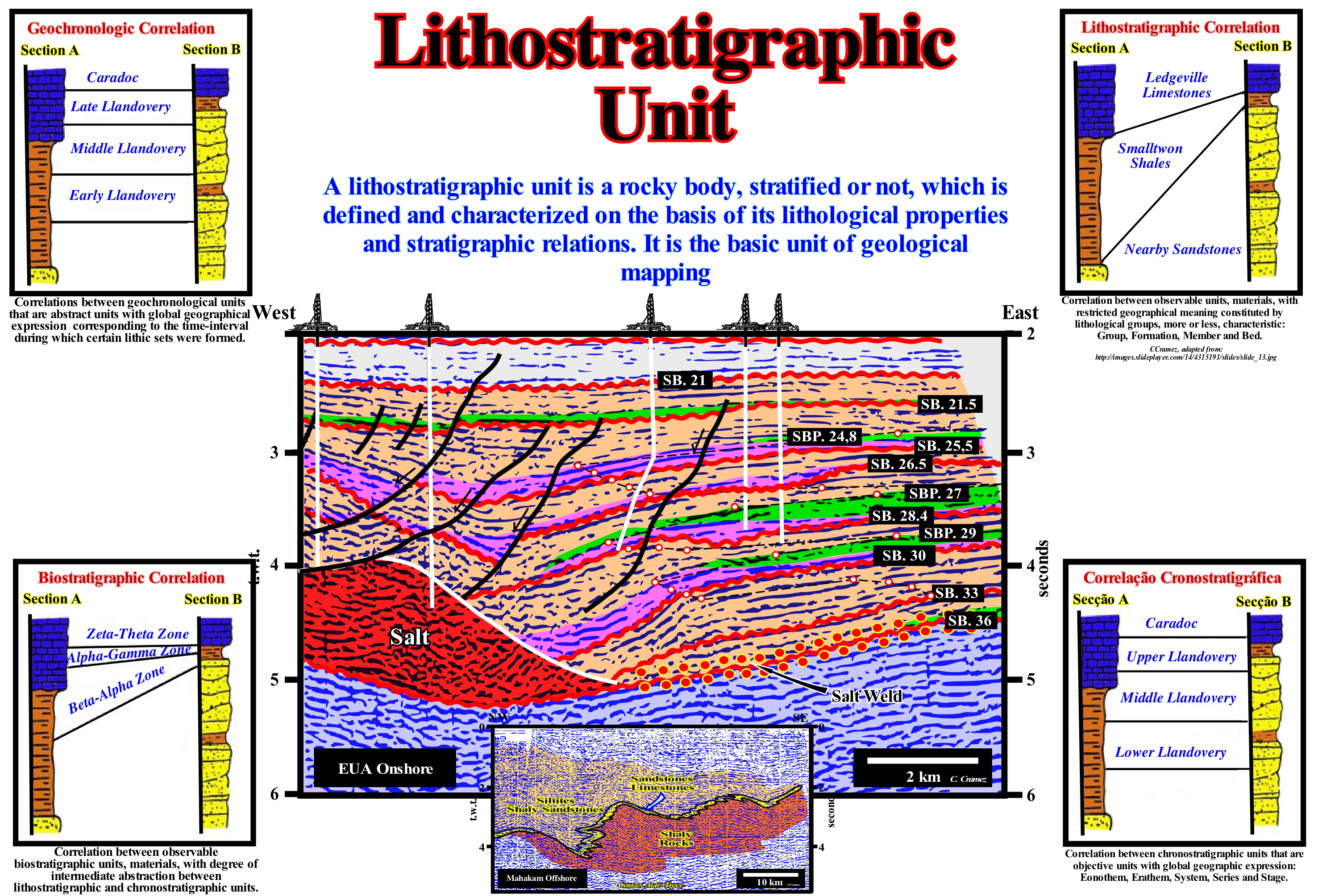
The strata can be sub-divided according to the physical characteristics, fossils that they contain and spatial relations between them. Three types of stratigraphic units are generally considered: (i) Lithological ; (ii) Biostratigraphic and (iii) Chronostratigraphic. A biostratigraphic unit is a set of rocks or strata unified by their fossils or paleontological characteristics, which differentiate them from the adjacent rocks or strata. It can be defined by: (a) The presence of fossils ; (b) The type of fossils it contains or, solely, by the fossils of a certain type ; (c) A taxon, which is a taxonomic unit, essentially associated with a scientific classification system, which may indicate a unit at any level ; (d) A particular association of fossils ; (e) The distribution of taxon or fossil taxa ; (f) the abundance of certain species of fossils ; (g) The morphological characteristics of the fossils ; (h) The way of life and habitat of fossilized organisms ; (i) The stages of evolutionary development of fossils ; (j) The variations of other factors related to the fossils that the strata contains, etc. A chronostratigraphic unit measures the geological time, which scale is based on the timing of major geological events occurring on Earth since its formation about 4.6 Ga. The main chronostratigraphic units are Era, Period, Age and Age, which correspond respectively to the chronostratigraphic units, Group or Erathem, System, Series, and stage or Sub-stage. A lithostratigraphic unit can be formed by sedimentary rocks, igneous, metamorphic and, in some cases, by an alternation of these types of rocks, which means that a lithostratigraphic unit corresponds to a rocky body to three dimensions. The concept of lithostratigraphic unit is applied vertically and laterally. There is no specific geographical extension for lithostratigraphic units, which always depends on the continuity and extension of the characteristics that are verified. In order to facilitate the field localization, geoscientists select the sites that most highlight these particularities. The lithostratigraphic units are divided into: (i) Group ; (ii) Formation ; (iii) Member and (iv) Bed. A group, which consists of two or more formations that do not need to be of the same location (a Super-group refers to the association of several Groups whose characteristics are inter-related, whereas Sub-group corresponds only to the set of some of the formations of a Group). The formation is a rocky-body identified by its lithological characteristics and stratigraphic position, the dimensions of which permit cartography. A member is characterized by the potential peculiarities of an area which differentiates it from the rest of the adjacent formation. A bed is a stratum whose thickness can vary from 1 cm to several meters and whose contact, which may correspond to a stratigraphic discontinuity. The upper and lower limits may be of several types: abrupt, gradual, undulating, etc. On this tentative of geological interpretation of a Canvas auto-trace of a detail of a Texas onshore seismic line, made at the hierarchical level of the sequence-cycles, the different groups of sedimentary systems tracts, individualized within each sequence-cycle, can be considered, in an approximate way, as lithostratigraphic units. Each sedimentary systems tract, which corresponds to a sequence-paracycle consists of two or three depositional systems (each depositional system is characterized by a lithology and associated fauna). A sequence-paracycle is induced by an eustatic paracycle (relative sea level rise), but it is deposited during the stability period of relative sea level that occurs between successive eustatic paracycles (there is any relative sea level fall between the eustatic paracycles). The basic lithostratigraphic unit is the Formation, which has an intermediate position in the hierarchy of lithostratigraphic units. It is the only formal unit that is used to subdivide the entire world stratigraphic column into units on the basis of lithological characteristics. As stated above, geological formations (a set of rocks or minerals that have their own characteristics in relation to their composition, age, origin or other similar properties) are subdivided in members and beds. A member is always a part of a formation, but a formation is not necessarily divided into members. According to the International Guide to Classification Stratigraphy, the formal name of a stratigraphic unit should be the name of the geographical location where it emerges in combination with the appropriate term of its hierarchy (Group, Formation, Member, Layer). The "La Lluna" formation, for example, known for its source-rock characteristics, is the typical lithological unit of Cenomanian-Turonian of Venezuela onshore and offshore.
Lithostratigraphy (Rock stratigraphy)..............................................................................................................Lithostratigraphie
Litostratigrafia / Litoestratigrafia / Lithostratigraphie / 岩石地层 / Литостратиграфия / Litostratigrafia /
Study of the succession and age of stratified rocks (endogenous) or scientific study of the physical characteristics of strata.
See: « Stratigraphy »
« Stratigraphic Cycle »
&
« Sequential Stratigraphy »

In this figure, two tentative interpretation of a Canvas auto-trace of a Mahakam offshore seismic line (Indonesia, West of the island of Borneo), which corresponds to a back-arc basin, practically without oceanization (sea floor spreading), that is, without formation of no-Atlantic divergent margin (mediterranean-type basin). One of the tentatives (left) was made in lithostratigraphic terms, while the other one was made in allostratigraphic terms (mapping of the rocky units based in deposition time). In the first tentative, the geoscientist tried to map the different facies (lithology with an associated fauna) without taking into account the biostratigraphy. He highlighted three areas with characteristic facies: (i) Siltites and Shaly Sandstones, deposited in a vertical succession of deltaic plains ; (ii) Sandstones and Limestones, deposited in a vertical succession of delta fronts of a delta building (not to be confused with a delta) and (iii) Shaly rocks deposited in a progradational succession of prodeltas, which in most cases constituted the upper part of the continental slope (when the basin has no shelf), which means that the delta front coincided with the continental edge, which may or may not coincide with the basin edge (take into account the seismic resolution that prevents the recognition transgressive seismic intervals of thickness equal to or less than the vertical seismic resolution, i.e., of the order of 20/40 meters). In the allostratigraphic interpretation, the geoscientist mapped not only the different facies, but also the main chronostratigraphic lines. These chronostratigraphic lines, which emphasize the most important seismic reflectors, will allow the interpreter to recognize, in a second phase of the interpretation, the main seismic surfaces*, and thus recognizing significant fall of the relative sea level, which is the result of the combined action of tectonic and the absolute or eustatic sea level (supposed global, referenced to the Earth's centre). A comparison between these two interpretations makes it easy to state that the boundaries of the facies are diachronic and thus oblique to the chronostratigraphic lines (seismic reflectors), which roughly represent depositional surfaces. The abrupt variations of the facies indicate not only episodes of progradation (increasingly important sedimentary regressions induced by increasingly smaller marine ingressions), but also of retrogradation (transgressions, i.e., set of increasingly important marine ingressions and increasingly smaller sedimentary regressions deposited during the stability period of relative sea level occurring after each marine ingression), as well as, episodes of negative aggradation, which underline significant relative sea level falls, which mark the location of the unconformities. In fact an unconformity that is induced by a significant the relative sea level can be recognized by a seaward (progradation) and downward (negative aggradation) displacement of the shoreline, which is not the case during sedimentary regressions that can be recognized by the displacement seaward (progradation) and upward (positive aggradation) of the shoreline. In the first case, the relative sea level falls, significantly, while in the second case the relative sea level rises in deceleration (marine ingressions increasingly smaller). In the tentative allostratigraphic interpretation, the unconformities correspond to the seismic surfaces defined by the onlaps, which limit the different stratigraphic cycles. In the allostratigraphic tentative interpretation, the boundaries between the stratigraphic units follow time lines (chronostratigraphic surfaces) and not facies lines (lithological surfaces). Lithological predictions and, in particular, the most probable reservoir-rock predictions can not be made simply by looking at a seismic line, they require a precise methodological approach from the scope of what is termed Seismostratigraphy **.
(*) Surfaces defined by reflector terminations: onlaps, downlaps and toplaps.
(**) Interpretation in stratigraphic data of the seismic data, considering that the primary seismic reflections are generated by physical interfaces between sedimentary intervals (sets of layers of thickness greater than or equal to the vertical resolution of the seismic lines), characterized by different values of seismic velocity and density (acoustic impedance). Such a stratigraphic interpretation involves the identification of stratigraphic cycles induced by eustatic cycles whose time-duration determines the order of magnitude, assuming that the rate of variations of the absolute (eustatic) sea level is faster than that of the tectonic variations, that is, assuming that is the eustasy that determines the cyclicity of the sedimentary deposits.
Lithothamnium (Algae)...................................................................................................................................................................Lithothamnium
Lithothamnium (alga) / Lithothamnium (alga) / Lithothamnium (Algen) / Lithothamnium(藻类) / Обызвествлённая морская водоросль / Lithothamnium (alghe) /
Alga of the red algae family. It presents in the form of small skeletons similar to the one of the corals. Its branches are composed of limestone impregnated with mineral elements and trace elements fixed from sea water. These elements are in an assimilable form since lithothamnium has an excellent porosity.
See: « Algae »
&
« Brown Algae (Phaeophyceae) »
&
« Limestone »

Coral red algae have a deposit of calcium carbonate in their cell walls, which makes them very resistant and without flexibility. They are very abundant and ecologically important because they can form large coral reefs. Some algae have an economic importance, in food or in the secondary production of mainly used products. in the food and pharmaceutical industry (culture medium for micro-organisms, capsules, suppositories, anticoagulants, photographic film, soap, hand cream, replaces gelatin, creams, jellies, mayonnaise, puddings, meringues, among others). Among the pigments that their cells possess may be chlorophylls and phycoerythrin (pigment which gives them a reddish colour). The Lithothamnium Angolense Romance 1916 is a typical Lithothamnium. It is a coralinacea with a thin stalk (50/150 microns) and, probably, not fixed. The stem is a vegetative structure undifferentiated in root, stem and leaf, and without formation of any tissue. The vast majority of macro-algae are composed of stems. The hypotaloid (marginal excretion of hyphae in the algal stalk of fouling) is absent or reduced to short cell lines. The peritoneum consists of cells (15 x 8/9 microns), arranged in rows rather than rows. The conceptacles (250/300 x 115/125 microns), which are seaweed and freshwater cavities containing the reproductive organs, are quite common and may contain at 6 pores. These reproductive organs create a slight protuberance of the stalk, given its thin thickness. This determination corresponds in all points to that described in the Albian of Angola. This is the first time that this form is known outside of its locality type and is also the first time it can be photographed. Stratigraphically it is the first known Lithothamnium. However a slight reservation must be advanced: it concerns the drawings of the original description which do not seem to illustrate the text correctly.

